Maitenbeth
| coat of arms | Germany map | |
|---|---|---|

|
Coordinates: 48 ° 9 ' N , 12 ° 6' E |
|
| Basic data | ||
| State : | Bavaria | |
| Administrative region : | Upper Bavaria | |
| County : | Mühldorf am Inn | |
| Management Community : | Maitenbeth | |
| Height : | 609 m above sea level NHN | |
| Area : | 30.94 km 2 | |
| Residents: | 2037 (Dec. 31, 2019) | |
| Population density : | 66 inhabitants per km 2 | |
| Postal code : | 83558 | |
| Area code : | 08076 | |
| License plate : | MÜ, VIB , WS | |
| Community key : | 09 1 83 126 | |
| LOCODE : | DE MTB | |
| Community structure: | 58 districts | |
| Address of the municipal administration: |
Haager Strasse 5 83558 Maitenbeth |
|
| Website : | ||
| Mayor : | Thomas Stark ( Maitenbeth Citizens List ) | |
| Location of the municipality of Maitenbeth in the Mühldorf am Inn district | ||
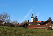
Maitenbeth ( Bavarian : Moabeth ) is a municipality in the Upper Bavarian district of Mühldorf am Inn and a member of the Maitenbeth administrative community .
geography
Geographical location
The source of the Isen , a tributary of the Inn, is located in the area of the municipality of Maitenbeth .
Maitenbeth is 40 km east of Munich and 35 km north of Rosenheim on the B 12 .
Neighboring communities
The municipality of Maitenbeth borders in the east on Haag in Oberbayern (MÜ) , in the south on Rechtmehring (MÜ) , Albaching (RO) and Steinhöring (EBE) , in the west on Hohenlinden (EBE) and in the north on Isen (ED) .
Community structure
The municipality of Maitenbeth has 58 districts:
history
Until the church is planted
The current district of Etschloh is mentioned in 977 AD, Maitenbeth (as Aetenpeth) not until 1315 AD, for the first time in a Freising register . The name Aetenpeth is made up of “Aeten” - a modification of the name Aite, which originated from Agathe - and “beth” - which means resting place. The letter M was probably created by amalgamating an (unknown) preceding word with the root word. The name Maitenbeth means “place where holy Agathe rests”.
In the Middle Ages until 1804, Maitenbeth and the surrounding villages and hamlets belonged to the Free Imperial County of Haag . The county of Haag did not belong to Bavaria, but was an independent empire of its own. The western border of the county still forms the western border of the Maitenbeth community today. At this border the French revolutionary troops clashed with the southern German troops (Austrians, Bavarians, Württemberg, Hesse, Liechtensteiners) in 1800. On December 3, 1800, the decisive battle of the Battle of Hohenlinden was fought around Maitenbeth .
In 1882 the two communities Maitenbeth and Innach merged in a kind of territorial reform.
Administrative affiliation
After the dissolution of the district of Wasserburg am Inn in 1972, Maitenbeth became part of the district of Mühldorf am Inn and, in 1978, of the Haag administrative community, but only for two years. Since 1980 Maitenbeth has formed an administrative community with the neighboring community of Rechtmehring.
timeline
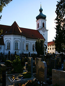
According to the "Chronicle of Maitenbeth" (1858) by the Expositus Franz Haistrachers, there was a church in Maitenbeth as early as 1488. The parish church of St. Agatha got its present form from 1680, in 1707 it was consecrated.
- 1800 - Abused as a field blacksmith and army camp by Austrian troops
- 1840 - Own cemetery
- 1847 - Appointment to the branch
- 1873 - Appointment to the parish
- 1940 - On September 8th, the church tower was struck by lightning and burned out completely
- 1984 - construction of an additional cemetery
- 1991 - Foundation of the parish association Maitenbeth-Rechtmehring
Maitenbeth was part of the Hague County .
Incorporations
On January 1, 1882, the previously independent community of Innach was incorporated.
Population development
Between 1988 and 2018 the municipality grew from 1,655 to 2,029 by 374 inhabitants or by 22.6%.
|
|
|
¹ Including the then still independent part of the municipality Innach
politics
mayor
Mayor is Thomas Stark ( Maitenbeth Citizen List ).
coat of arms
Description : The coat of arms, which is divided diagonally to the right, shows a raven in gold with a bloody wood chip in its beak; below in the blue field a silver white horse for the county of Haag .
Architectural monuments
Public facilities
Maitenbeth has a primary school. The current building was inaugurated in 1964 and expanded in 1991. It forms a joint secondary school with the school in Rechtmehring. A kindergarten has existed since 1974, and in 2004 he moved to a new building.
Transport and infrastructure
Maitenbeth is located on the busy B 12 (Lindau - Munich - Passau) and not far from the north-south running B 15. There are bus connections to Munich and Haag / Gars am Inn. To monitor the airspace, there is a DFS tower with an SRE-M radar system in the Großhaager Forest southwest of Maitenbeth . Each of these six systems nationwide has a detection radius of around 145 NM ( nautical miles , corresponds to 270 km).
Personalities
The painter Peter Casagrande (* 1946) lives and works in Maitenbeth.
Others
In 2007 the soccer player Marek Krejčí died in a car accident near Maitenbeth.
Individual evidence
- ↑ "Data 2" sheet, Statistical Report A1200C 202041 Population of the municipalities, districts and administrative districts 1st quarter 2020 (population based on the 2011 census) ( help ).
- ↑ maitenbeth.de: Mayor's office
- ↑ Entry in the location database
- ↑ Below Stefan von, Stefan Breit: Forest - from God's gift to private property: Judicial conflicts between sovereigns and subjects over the forest in the early modern period , Stuttgart 1998, p. 101, ISBN 978-3-8282-0079-1
- ^ Wilhelm Volkert (ed.): Handbook of Bavarian offices, communities and courts 1799–1980 . CH Beck, Munich 1983, ISBN 3-406-09669-7 , p. 589 .
Web links
- Site of the Maitenbeth community
- Entry on the coat of arms of Maitenbeth in the database of the House of Bavarian History


