
Zangberg
| coat of arms | Germany map | |
|---|---|---|

|
Coordinates: 48 ° 16 ' N , 12 ° 26' E |
|
| Basic data | ||
| State : | Bavaria | |
| Administrative region : | Upper Bavaria | |
| County : | Mühldorf am Inn | |
| Management Community : | Oberbergkirchen | |
| Height : | 430 m above sea level NHN | |
| Area : | 9.84 km 2 | |
| Residents: | 1122 (Dec. 31, 2019) | |
| Population density : | 114 inhabitants per km 2 | |
| Postal code : | 84539 | |
| Primaries : | 08636, 08637 | |
| License plate : | MÜ, VIB , WS | |
| Community key : | 09 1 83 151 | |
| Community structure: | 20 districts | |
| Association administration address: | Hofmark 28 84564 Oberbergkirchen, Germany |
|
| Website : | ||
| Mayor : | Georg Auer ( Zangberg voters' association ) | |
| Location of the municipality of Zangberg in the Mühldorf am Inn district | ||
  |
||

Zangberg is a municipality in the Upper Bavarian district of Mühldorf am Inn and a member of the Oberbergkirchen administrative community .
geography
Geographical location
Zangberg is located in the region of southeast Upper Bavaria on the northern edge of the Isental and forms the entrance to the Tertiary Lower Bavarian hill country.
Community structure
The community of Zangberg has 20 districts:
|
* These districts have the telephone code 08637.
There are the districts of Weilkirchen and Zangberg.
history

Until the church is planted
Zangberg was first mentioned in a document in 1285, while the community part of Weilkirchen is attested as early as 788. The place belonged to the Landshut Rent Office and the Neumarkt Regional Court of the Electorate of Bavaria. The Countess von der Wahl owned the open Hofmark Zangberg here around 1800 . In the course of the administrative reforms in Bavaria, today's municipality was created with the municipal edict of 1818.
The townscape is determined by the construction of today's St. Josef Monastery in the 17th century . The BSH Academy of BSH Hausgeräte GmbH and the training rooms of Capgemini sd & m are now located in the rooms of the former Higher Daughter School of the Salesians in Zangberg , whose most famous student was probably Zita von Bourbon-Parma .
Incorporations
On October 1, 1937, the previously independent community of Weilkirchen was incorporated.
Population development
Between 1988 and 2018 the community grew from 810 to 1,116 by 306 inhabitants or 37.8%.
- 1840: 476 inhabitants
- 1871: 673 inhabitants
- 1900: 689 inhabitants
- 1925: 712 inhabitants
- 1939: 596 inhabitants
- 1950: 909 inhabitants
- 1961: 695 inhabitants
- 1970: 569 inhabitants
- 1987: 800 inhabitants
- 1991: 845 inhabitants
- 1995: 922 inhabitants
- 2000: 947 inhabitants
- 2005: 1015 inhabitants
- 2010: 1082 inhabitants
- 2015: 1106 inhabitants
politics
City council and mayor
In the local elections in Bavaria in 2020 , the Zangberg electoral association received 12 seats in the municipal council, and Bündnis 90 / Die Grünen 2 seats. Mayor is Georg Auer (Zangberg Voting Association). He was elected on March 15, 2020 with 523 out of 630 valid votes.
coat of arms
Official description of the coat of arms: In silver over a green three-hill a slanting red forge tongs.
Attractions
- Catholic parish church Herz Jesu. A large crucifix deserves particular attention from the furnishings, as it is a remnant of the Benno arch of the Munich Frauenkirche , which was broken off in 1858 .
- Zangberg Monastery , the former Zangberg Castle
- Church of St. Peter and Paul in Palmberg (grave of the poet Martin Greif )
- Church of St. Georg in Weilkirchen

town hall

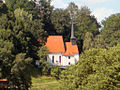
Church of the Sacred Heart

St. Josef Monastery, west view

St. Josef Monastery, south view

Church of St. Peter and Paul in Palmberg
Church of St. Georg in Weilkirchen

Church of the Sacred Heart, front side


Economy and Infrastructure
economy
In 1998 there were no employees subject to social insurance contributions at work in the fields of agriculture and forestry, in the manufacturing sector, or in trade and transport. In other economic areas, 60 people were employed at the place of work subject to social security contributions. There were a total of 272 employees at the place of residence subject to social insurance contributions. There were 5 companies in the manufacturing sector and 3 companies in the main construction sector. The large difference between those who work in the village and those who live in the town shows that Zangberg is a typical commuter community .
In addition, in 1999 there were 27 farms with an agriculturally used area of 767 hectares. Of this, 579 hectares were arable land and 188 hectares were permanent green areas.
education
In Zangberg there is a municipal kindergarten (35 places) and a primary school (status: 2009).
Personalities
- Joseph Ritter von Petzl (1764–1817), Bavarian clergyman, mineralogist and natural scientist.
- Marianne Zollner (* 1956), politician, grew up in Zangberg.
Individual evidence
- ↑ "Data 2" sheet, Statistical Report A1200C 202041 Population of the municipalities, districts and administrative districts 1st quarter 2020 (population based on the 2011 census) ( help ).
- ↑ http://www.bayerische-landesbibliothek-online.de/orte/ortssuche_action.html ? Anzeige=voll&modus=automat&tempus=+20120105/190243&attr=OBJ&val= 423
- ^ Wilhelm Volkert (ed.): Handbook of Bavarian offices, communities and courts 1799–1980 . CH Beck, Munich 1983, ISBN 3-406-09669-7 , p. 525 .
- ↑ Bavarian State Office for Statistics and Data Processing (Hrsg.): The municipalities of Bavaria according to the territorial status May 25, 1987. The population of the municipalities of Bavaria and the changes in the acquisitions and territory from 1840 to 1987 (= contributions to Statistics Bavaria . Issue 451). Munich 1991, p. 49 , urn : nbn: de: bvb: 12-bsb00070717-7 ( digitized version ).
- ↑ Results. Retrieved March 26, 2020 .
- ↑ Results of the mayoral election of Zangberg 2020. Accessed on March 26, 2020 .
Web links
- Entry on the coat of arms of Zangberg in the database of the House of Bavarian History

Ampfing |
Aschau am Inn |
Buchbach |
Egglkofen |
Erharting |
Gars am Inn |
Hague in Upper Bavaria |
Hero's Stone |
Jettenbach |
Kirchdorf |
Kraiburg am Inn |
Lohkirchen |
Maitenbeth |
Mettenheim |
Mühldorf am Inn |
Neumarkt-Sankt Veit |
Niederbergkirchen |
Niedertaufkirchen |
Oberbergkirchen |
Oberneukirchen |
Obertaufkirchen |
Polling |
Rat churches |
Right more |
Reichertsheim |
Schoenberg |
Schwindegg |
Taufkirchen |
Unterreit |
Waldkraiburg |
Zangberg
Unregulated areas in the district of Mühldorf a.Inn
Mühldorfer Hart