
Hero stone
| coat of arms | Germany map | |
|---|---|---|

|
Coordinates: 48 ° 15 ' N , 12 ° 22' E |
|
| Basic data | ||
| State : | Bavaria | |
| Administrative region : | Upper Bavaria | |
| County : | Mühldorf am Inn | |
| Management Community : | Hero stone | |
| Height : | 450 m above sea level NHN | |
| Area : | 19.85 km 2 | |
| Residents: | 2678 (Dec. 31, 2019) | |
| Population density : | 135 inhabitants per km 2 | |
| Postal code : | 84431 | |
| Area code : | 08636 | |
| License plate : | MÜ, VIB , WS | |
| Community key : | 09 1 83 120 | |
| LOCODE : | DE HDS | |
| Community structure: | 23 districts | |
| Address of the municipal administration: |
Schulstrasse 5a 84431 Heldenstein |
|
| Website : | ||
| First Mayor : | Antonia Hansmeier ( CSU ) | |
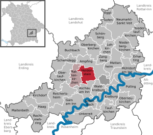
| Location of the municipality of Heldenstein in the Mühldorf am Inn district | ||
  |
||

Heldenstein is a municipality and a town in the Upper Bavarian district of Mühldorf am Inn and the seat of the Heldenstein administrative community .
geography
location
The municipality is located in the region of southeast Upper Bavaria in the Alpine foothills between the Isen and Inn rivers, around 13 km west of the district town of Mühldorf , 20 km east of Dorfen and 67 km from the state capital Munich .
Community structure
There are 23 districts:
|
There are the districts of Heldenstein, Lauterbach and Weidenbach.
Neighboring communities
history
Heldenstein appears for the first time in Salzburg documents around 1050. Heldenstein belonged to the Landshut Rent Office and the Neumarkt Regional Court of the Electorate of Bavaria. Through the Oberamt Ampfing, the Archbishopric of Salzburg exercised lower jurisdiction over its subjects in this area until its abolition in 1803. In the course of the administrative reforms in Bavaria , the municipality of Heldenstein was created with the municipal edict of 1818 .
Assignments
On April 1, 1950, the community ceded parts of the area to the newly formed community of Waldkraiburg .
Incorporations
On January 1, 1970, the previously independent community of Lauterbach was incorporated. Weidenbach was added on May 1, 1978 .
Administrative communities
The Ampfing administrative community, founded in 1978 with the member communities of Ampfing, Heldenstein, Rattenkirchen and Mettenheim, was dissolved again the following year. While Ampfing and Mettenheim received their own administrations as unified municipalities, the two other members formed the Heldenstein administrative community on January 1, 1980 .
Population development
Between 1988 and 2018 the municipality grew from 1,950 to 2,629 by 679 inhabitants or 34.8%.
- 1961: 1161 inhabitants
- 1970: 1170 inhabitants
- 1987: 1812 inhabitants
- 1991: 2175 inhabitants
- 1995: 2277 inhabitants
- 2000: 2369 inhabitants
- 2005: 2391 inhabitants
- 2010: 2402 inhabitants
- 2015: 2518 inhabitants
Attractions

In the Kirchbrunn district, the late Baroque pilgrimage church Maria Schnee is worth seeing, as is the branch church of St. Nikolaus in Niederheldenstein.
politics
The first female mayor is ( CSU ).
coat of arms
|
|
Blazon : “Split between red and gold; in front over two silver wavy bars a stalked silver lily pad, behind a green, red-armored panther. " |
Economy and Infrastructure
Economy including agriculture and forestry
In 1998 there were no employees at the place of work in agriculture and forestry, 178 in manufacturing and no in trade and transport. In other areas of the economy 106 people were employed at the place of work subject to social security contributions. There were a total of 786 employees at the place of residence subject to social security contributions. In the manufacturing sector (as well as mining and quarrying of stones and earth) there were 21 companies, in the construction industry nine companies.
In addition, in 1999 there were 52 farms with an agricultural area of 1412 ha. Of this, 1072 ha were arable land.
traffic

Heldenstein is located directly at the confluence of the B 12 with the A 94 motorway, which was released on October 1, 2019, and is connected to this via junction 17. The district of Weidenbach is on the Munich – Simbach railway line and is served by regional trains of the Südostbayernbahn several times a day.
education
The following institutions exist (as of: 1999):
- Kindergartens: 50 kindergarten places with 67 children
- Elementary schools: one with eleven teachers and 166 students
Personalities
Born in Heldenstein
- Ingrid Heckner (* 1950), Member of the Bavarian State Parliament (CSU)
Died in Heldenstein
- Roy Black (1943-1991)
Web links
Individual evidence
- ↑ "Data 2" sheet, Statistical Report A1200C 202041 Population of the municipalities, districts and administrative districts 1st quarter 2020 (population based on the 2011 census) ( help ).
- ↑ Entry in the location database
- ↑ a b Wilhelm Volkert (Ed.): Handbook of the Bavarian offices, communities and courts 1799–1980 . CH Beck, Munich 1983, ISBN 3-406-09669-7 , p. 525 .
- ^ Federal Statistical Office (ed.): Historical municipality directory for the Federal Republic of Germany. Name, border and key number changes in municipalities, counties and administrative districts from May 27, 1970 to December 31, 1982 . W. Kohlhammer, Stuttgart / Mainz 1983, ISBN 3-17-003263-1 , p. 583 .
- ↑ Mayor. Congregation, accessed August 15, 2020 .
- ^ Entry on the Heldenstein coat of arms in the database of the House of Bavarian History

Ampfing |
Aschau am Inn |
Buchbach |
Egglkofen |
Erharting |
Gars am Inn |
Hague in Upper Bavaria |
Hero's Stone |
Jettenbach |
Kirchdorf |
Kraiburg am Inn |
Lohkirchen |
Maitenbeth |
Mettenheim |
Mühldorf am Inn |
Neumarkt-Sankt Veit |
Niederbergkirchen |
Niedertaufkirchen |
Oberbergkirchen |
Oberneukirchen |
Obertaufkirchen |
Polling |
Rat churches |
Right more |
Reichertsheim |
Schoenberg |
Schwindegg |
Taufkirchen |
Unterreit |
Waldkraiburg |
Zangberg
Unregulated areas in the district of Mühldorf a.Inn
Mühldorfer Hart