
Kirchdorf (near Haag in Upper Bavaria)
| coat of arms | Germany map | |
|---|---|---|

|
Coordinates: 48 ° 11 ' N , 12 ° 12' E |
|
| Basic data | ||
| State : | Bavaria | |
| Administrative region : | Upper Bavaria | |
| County : | Mühldorf am Inn | |
| Management Community : | Reichertsheim | |
| Height : | 551 m above sea level NHN | |
| Area : | 21.03 km 2 | |
| Residents: | 1340 (Dec. 31, 2019) | |
| Population density : | 64 inhabitants per km 2 | |
| Postal code : | 83527 | |
| Area code : | 08072 | |
| License plate : | MÜ, VIB , WS | |
| Community key : | 09 1 83 123 | |
| Community structure: | 50 districts | |
| Association administration address: | Bräustr. 11 84437 Reichertsheim |
|
| Website : | ||
| Mayor : | Alfons Linner (Free Voters Association Berg) | |
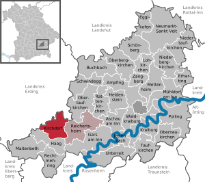
| Location of the municipality of Kirchdorf in the Mühldorf am Inn district | ||
  |
||


Kirchdorf is a municipality in the Upper Bavarian district of Mühldorf am Inn and a member of the Reichertsheim administrative community .
geography
Geographical location
Kirchdorf is located in the region of southeast Upper Bavaria in the foothills of the Alps on a hill with a view of the neighboring town of Haag and the chain of the Bavarian Alps . The Ornaubach , which rises in the north of the municipality, is the southern border of the Gattergebirge . Kirchdorf is located at the intersection of federal highways 15 and 12, around 20 kilometers west of Waldkraiburg , 17 kilometers north of Wasserburg , 51 kilometers east of the state capital Munich , 15 kilometers south of Dorfen and 30 kilometers from the district town of Mühldorf am Inn . The two nearest train stations are in Soyen and Gars am Inn , which are regularly served by the Südostbayernbahn .
Markings
There are the districts Berg, Fürholzen and Kirchdorf.
Parish parts
Kirchdorf has the following 50 districts:
Neighboring communities
history
Until the church is planted
Kirchdorf "Pohchurdorf" was first mentioned in writing in 790. The local noble family of the Gurren von Kirchdorf, resident in Kirchdorf, is mentioned from 1140 to 1245 and founded the Free County of Haag around 1200, to whose rule Kirchdorf belonged until 1804. Kirchdorf was the cultural and religious center of the Free County of Haag , which existed from 1200 to 1804. The parish church of the Assumption of the Virgin Mary of Kirchdorf, which (in 1315) had 14 branch churches, was built around 1200 by the Gurren in Romanesque style, and in 1472 by Count Hans VI. von Haag rebuilt in Gothic style and redesigned in Baroque style around 1690. The crypt of Kirchdorf (lower church) is the hereditary burial place of the imperial counts of Haag. The largest grave monument of these counts, the sarcophagus of Count Ladislaus zu Hag, is today in the Bavarian National Museum in the entrance hall. The church of Kirchdorf houses the remains of the Blessed Kasta from the catacombs of Rome in a glass shrine in the left side altar.
Kirchdorf belonged to the Munich Rent Office and to the Hague Regional Court of the Electorate of Bavaria . In the course of the administrative reforms in Bavaria , today's municipality was created with the municipal edict of 1818 .
Incorporations
On April 1, 1971, the previously independent communities Berg and Fürholzen were incorporated.
Population development
Between 1988 and 2018 the municipality grew from 1,182 to 1,355 by 173 inhabitants or 14.6%.
- 1961: 1196 inhabitants
- 1970: 1216 inhabitants
- 1987: 1162 inhabitants
- 1991: 1217 inhabitants
- 1995: 1248 inhabitants
- 2000: 1260 inhabitants
- 2005: 1291 inhabitants
- 2010: 1326 inhabitants
- 2015: 1339 inhabitants
politics
Mayor is Alfons Linner sen. (Free constituency of Berg).
Architectural monuments
Soil monuments
Economy and Infrastructure
Economy including agriculture and forestry
In 1998 there were 6 employees in the field of agriculture and forestry, 87 in the manufacturing sector and 11 in the trade and transport sector at the place of work. In other economic areas, 16 people were employed at the place of work subject to social security contributions. There were a total of 384 employees at the place of residence subject to social security contributions. There were no companies in the manufacturing sector and 5 companies in the main construction sector. In addition, in 1999 there were 76 farms with an agriculturally used area of 1297 hectares. Of this, 638 hectares were arable land and 658 hectares were permanent green areas.
The largest employer in the municipality is Schletter GmbH .
energy
Three solar power plants, each with a capacity of 100 kW, have been in a nearby area between Öd, Wella and Au since 2003.
education
The following institutions exist (as of: 1999):
- Kindergarten: 50 kindergarten places with 44 children
Personalities
- Christian Grainer , (1964 *) Cooking with a star in the Michelin guide awarded
Individual evidence
- ↑ "Data 2" sheet, Statistical Report A1200C 202041 Population of the municipalities, districts and administrative districts 1st quarter 2020 (population based on the 2011 census) ( help ).
- ↑ http://www.bayerische-landesbibliothek-online.de/orte/ortssuche_action.html ? Anzeige=voll&modus=automat&tempus=+20120104/130243&attr=OBJ&val= 402
- ^ Wilhelm Volkert (ed.): Handbook of Bavarian offices, communities and courts 1799–1980 . CH Beck, Munich 1983, ISBN 3-406-09669-7 , p. 589 .
Web links
- Entry on the coat of arms of Kirchdorf (near Haag in Upper Bavaria) in the database of the House of Bavarian History

Ampfing |
Aschau am Inn |
Buchbach |
Egglkofen |
Erharting |
Gars am Inn |
Hague in Upper Bavaria |
Hero's Stone |
Jettenbach |
Kirchdorf |
Kraiburg am Inn |
Lohkirchen |
Maitenbeth |
Mettenheim |
Mühldorf am Inn |
Neumarkt-Sankt Veit |
Niederbergkirchen |
Niedertaufkirchen |
Oberbergkirchen |
Oberneukirchen |
Obertaufkirchen |
Polling |
Rat churches |
Right more |
Reichertsheim |
Schoenberg |
Schwindegg |
Taufkirchen |
Unterreit |
Waldkraiburg |
Zangberg
Unregulated areas in the district of Mühldorf a.Inn
Mühldorfer Hart