
Oberneukirchen (Upper Bavaria)
| coat of arms | Germany map | |
|---|---|---|

|
Coordinates: 48 ° 10 ' N , 12 ° 31' E |
|
| Basic data | ||
| State : | Bavaria | |
| Administrative region : | Upper Bavaria | |
| County : | Mühldorf am Inn | |
| Management Community : | Polling | |
| Height : | 461 m above sea level NHN | |
| Area : | 19.6 km 2 | |
| Residents: | 851 (Dec. 31, 2019) | |
| Population density : | 43 inhabitants per km 2 | |
| Postal code : | 84565 | |
| Area code : | 08630 | |
| License plate : | MÜ, VIB , WS | |
| Community key : | 09 1 83 134 | |
| Community structure: | 76 districts | |
| Association administration address: | Monhamer Weg 1 84570 Polling |
|
| Website : | ||
| Mayoress : | Anna Meier ( FW / community of voters ) | |
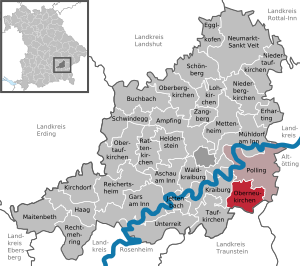
| Location of the municipality of Oberneukirchen in the Mühldorf am Inn district | ||
  |
||

Oberneukirchen is a municipality in the Upper Bavarian district of Mühldorf am Inn and a member of the Polling administrative community .

geography
Geographical location
Oberneukirchen is located in the southeast Upper Bavaria region.
Community structure
The municipality of Oberneukirchen has 76 districts:
There is only the district Oberneukirchen
history
Early settlement history
Oberneukirchen was first mentioned in 1151 as "Nivenchirchen" (Neukirchen). The Catholic parish church of St. Margareta, which is consecrated to Margaret of Antioch , was probably not built in Gothic style until 1430 . There has been evidence of school teaching in Oberneukirchen since 1671. In 1757 the church was redesigned in baroque style .
Oberneukirchen was part of the Burghausen Rent Office and the Mörmoosen Regional Court of the Electorate of Bavaria . The Archbishopric of Salzburg exercised lower jurisdiction over its subjects until it was abolished in 1803 .
Church Planting and Economic Growth
In the course of the administrative reforms in Bavaria , today's municipality was created with the municipal edict of 1818 . When the community was founded, Oberneukirchen consisted of 133 houses and farms.
Around 1840, changes in agriculture and livestock production ensured enormous growth. During this time, many houses are converted to meet the new conditions. From this time on, the economic and social life in Oberneukirchen also consolidated: From 1852 Oberneukirchen belongs to the delivery area of the Post-Expedition in Kraiburg . In 1823 a branch of the parish Flossing was founded in Oberneukirchen , and in 1861 it was raised to a parish. Today Oberneukirchen together with the parish Flossing and Kuratie Polling member Pfarrverband flossing. Between 1876 and 1879 the secondary sources of the Grünbach are fed to the main source and thus ensure sufficient water to operate the moss mill.
In 1879 the size of the population in Oberneukirchen leveled off at 830 to 860 inhabitants. This size is maintained until the beginning of the Second World War.
First World War and Weimar Republic
During the First World War , bread and meat are rationed and monitored by the gendarmerie .
In 1922, the church of St. Margareta was expanded to its present form for the time being, the last.
National Socialism
At the beginning of the Second World War in 1939, many young men from Oberneukirchen were called up for military service. The population of around 850, which has remained largely constant since 1879, is falling significantly. At that time, the community of Oberneukirchen was mainly characterized by the surrounding farms; the place itself had little more than 10 houses. Above all, the surrounding farmers were affected by the draft: there was a short-term shortage of workers.
This situation only changes when prisoners of war and civilian workers from the East are used to work on the farms. From 1942 many evacuated families from Munich were also housed in Oberneukirchen.
Immediately after the war, leaving the prisoners of war and evacuated families Oberneukirchen again, while the Wehrmacht convened soldiers return home only very slowly from the war. In the immediate post-war period, there is again a labor shortage, which affects farmers in particular. This problem is exacerbated by a delivery quota of farmers against the American occupation force .
Post war and consolidation
In 1946, initially displaced persons from the Sudetenland came to Oberneukirchen and replaced the lacking workforce in agriculture. The community grew to 1,350 inhabitants by 1949. At the beginning of the 1950s, there was enormous economic growth in the surrounding towns. Many of the expellees therefore settled permanently in Waldkraiburg , Weiding or Töging am Inn and left Oberneukirchen. Despite the war returnees, the population fell again to 753 in 1962.
Raiffeisenstraße was built at the beginning of the 1970s.
Recent history
The early 1970s were a severe setback for Oberneukirchen. After the elementary and partial secondary school in Taufkirchen was assigned to the Oberneukirchen elementary school in 1969 , the Mühldorf District Office imposed a construction freeze on Oberneukirchen until the community was connected to the water supply from Taufkirchen. The construction of the aqueduct was not completed until 1983; at the same time the sewage treatment plant in Oberneukirchen was built.
Oberneukirchen's growth did not continue until the 1980s when the Lindenstrasse and Ringstrasse were built. In 1986 the community acquired the Wolfl grocery store and converted it into a community center. Today the parish hall is the center of club life in Oberneukirchen.
Population development
Between 1988 and 2018 the municipality grew from 672 to 851 by 179 inhabitants or by 26.6%.
The following inhabitants were counted in the municipality:
| year | Pop. |
|---|---|
| 1939 | 830 |
| 1950 | 1337 |
| 1955 | 1002 |
| 1961 | 770 |
| 1970 | 751 |
| 1983 | 682 |
| 1991 | 695 |
| 1995 | 737 |
| 2000 | 775 |
| 2005 | 818 |
| 2010 | 835 |
| 2015 | 843 |
politics
Mayor is Anna Meier. She was elected to succeed Franz Steiglechner in 2014.
Architectural monuments
Economy and Infrastructure
In 2017 there were a total of 119 employees subject to social insurance contributions at the place of work and 366 at the place of residence (out-commuter surplus: 247). Seven residents were unemployed. In 2016, 56 farms were counted with a utilized area of 1494 ha.
Web links
- Official website of Oberneukirchen
- Entry on the coat of arms of Oberneukirchen (Upper Bavaria) in the database of the House of Bavarian History
Individual evidence
- ↑ "Data 2" sheet, Statistical Report A1200C 202041 Population of the municipalities, districts and administrative districts 1st quarter 2020 (population based on the 2011 census) ( help ).
- ↑ http://www.bayerische-landesbibliothek-online.de/orte/ortssuche_action.html ? Anzeige=voll&modus=automat&tempus=+20120104/224014&attr=OBJ&val= 412

Ampfing |
Aschau am Inn |
Buchbach |
Egglkofen |
Erharting |
Gars am Inn |
Hague in Upper Bavaria |
Hero's Stone |
Jettenbach |
Kirchdorf |
Kraiburg am Inn |
Lohkirchen |
Maitenbeth |
Mettenheim |
Mühldorf am Inn |
Neumarkt-Sankt Veit |
Niederbergkirchen |
Niedertaufkirchen |
Oberbergkirchen |
Oberneukirchen |
Obertaufkirchen |
Polling |
Rat churches |
Right more |
Reichertsheim |
Schoenberg |
Schwindegg |
Taufkirchen |
Unterreit |
Waldkraiburg |
Zangberg
Unregulated areas in the district of Mühldorf a.Inn
Mühldorfer Hart