
Administrative community Heldenstein
| coat of arms | Germany map | |
|---|---|---|
 Help on coat of arms |
Coordinates: 48 ° 15 ' N , 12 ° 22' E |
|
| Basic data | ||
| State : | Bavaria | |
| Administrative region : | Upper Bavaria | |
| County : | Mühldorf am Inn | |
| Area : | 39.72 km 2 | |
| Residents: | 3657 (Dec. 31, 2019) | |
| Population density : | 92 inhabitants per km 2 | |
| License plate : | MÜ, VIB , WS | |
| Association key : | 09 1 83 5145 | |
| Association structure: | 2 municipalities | |
| Association administration address : |
Schulstr. 5a 84431 Heldenstein |
|
| Website : | ||
| Location of the Heldenstein administrative community in the Mühldorf am Inn district | ||
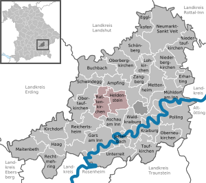  |
||

The administrative community Heldenstein is located in the Upper Bavarian district of Mühldorf am Inn and has been formed by the following communities since January 1st, 1980:
- Heldenstein , 2678 inhabitants, 19.85 km²
- Rattenkirchen , 979 inhabitants, 19.87 km²
The administrative association is based in Heldenstein.
At the beginning (1978) the two communities with Ampfing and Mettenheim formed the administrative community Ampfing , which was dissolved on December 31, 1979. Ampfing and Mettenheim became unitary communities with their own administrations.
Individual evidence
- ↑ "Data 2" sheet, Statistical Report A1200C 202041 Population of the municipalities, districts and administrative districts 1st quarter 2020 (population based on the 2011 census) ( help ).
- ↑ Law of August 10, 1979 (GVBl p. 223)
Administrative communities in the Mühldorf am Inn district
Gars a.Inn | Hero's Stone | Kraiburg a.Inn | Maitenbeth | Neumarkt-Sankt Veit | Oberbergkirchen | Polling | Reichertsheim | Rohrbach
Former: Ampfing | Hague in Upper Bavaria | Schwindegg