
Administrative community Oberbergkirchen
| coat of arms | Germany map | |
|---|---|---|
 Help on coat of arms |
Coordinates: 48 ° 18 ' N , 12 ° 23' E |
|
| Basic data | ||
| State : | Bavaria | |
| Administrative region : | Upper Bavaria | |
| County : | Mühldorf am Inn | |
| Area : | 77.58 km 2 | |
| Residents: | 4714 (Dec 31, 2019) | |
| Population density : | 61 inhabitants per km 2 | |
| License plate : | MÜ, VIB , WS | |
| Association key : | 09 1 83 5150 | |
| Association structure: | 4 municipalities | |
| Association administration address : |
Hofmark 28 84564 Oberbergkirchen, Germany |
|
| Website : | ||
| Community Chairman : | Franz Märkl ( CSU / Free Association of Voters ) | |
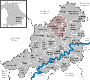
| Location of the Oberbergkirchen administrative community in the Mühldorf am Inn district | ||
  |
||

The Oberbergkirchen administrative community is located in the Upper Bavarian district of Mühldorf am Inn and is formed by the following communities:
- Lohkirchen , population 753, 14.88 km²
- Oberbergkirchen , 1726 inhabitants, 27.53 km²
- Schönberg , 1113 inhabitants, 25.33 km²
- Zangberg , population 1122, 9.84 km²
The administrative association is based in Oberbergkirchen.
Individual evidence
- ↑ "Data 2" sheet, Statistical Report A1200C 202041 Population of the municipalities, districts and administrative districts 1st quarter 2020 (population based on the 2011 census) ( help ).
Administrative communities in the Mühldorf am Inn district
Gars a.Inn | Hero's Stone | Kraiburg a.Inn | Maitenbeth | Neumarkt-Sankt Veit | Oberbergkirchen | Polling | Reichertsheim | Rohrbach
Former: Ampfing | Hague in Upper Bavaria | Schwindegg