
Administrative community Rohrbach
| coat of arms | Germany map | |
|---|---|---|
 Help on coat of arms |
Coordinates: 48 ° 17 ' N , 12 ° 35' E |
|
| Basic data | ||
| State : | Bavaria | |
| Administrative region : | Upper Bavaria | |
| County : | Mühldorf am Inn | |
| Area : | 65.07 km 2 | |
| Residents: | 3567 (Dec. 31, 2019) | |
| Population density : | 55 inhabitants per km 2 | |
| License plate : | MÜ, VIB , WS | |
| Association key : | 09 1 83 5152 | |
| Association structure: | 3 municipalities | |
| Association administration address : |
Rohrbach 20 84513 Erharting, Germany |
|
| Website : | ||
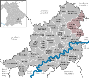
| Location of the Rohrbach administrative community in the Mühldorf am Inn district | ||
  |
||

The Rohrbach administrative community in the Upper Bavarian district of Mühldorf am Inn includes the member communities
- Erharting , population 919, 13.68 km²
- Niederbergkirchen , 1229 inhabitants, 24.7 km²
- Niedertaufkirchen , 1419 inhabitants, 26.69 km²
It was created in the early 1980s in order to preserve the political independence of the rural area between the district town of Mühldorf am Inn in the south and the town of Neumarkt-Sankt Veit in the north. The joint town hall of the administrative community is located in Rohrbach in the municipality of Erharting .

Individual evidence
- ↑ "Data 2" sheet, Statistical Report A1200C 202041 Population of the municipalities, districts and administrative districts 1st quarter 2020 (population based on the 2011 census) ( help ).
Administrative communities in the Mühldorf am Inn district
Gars a.Inn | Hero's Stone | Kraiburg a.Inn | Maitenbeth | Neumarkt-Sankt Veit | Oberbergkirchen | Polling | Reichertsheim | Rohrbach
Former: Ampfing | Hague in Upper Bavaria | Schwindegg