
Forestry
| coat of arms | Germany map | |
|---|---|---|

|
Coordinates: 48 ° 11 ' N , 11 ° 59' E |
|
| Basic data | ||
| State : | Bavaria | |
| Administrative region : | Upper Bavaria | |
| County : | Erding | |
| Height : | 520 m above sea level NHN | |
| Area : | 15.37 km 2 | |
| Residents: | 3695 (Dec. 31, 2019) | |
| Population density : | 240 inhabitants per km 2 | |
| Postal code : | 85659 | |
| Area code : | 08124 | |
| License plate : | ED | |
| Community key : | 09 1 77 119 | |
| LOCODE : | DE FON | |
| Address of the municipal administration: |
Main street 15 85659 Forstern |
|
| Website : | ||
| Mayor : | Rainer Streu (Old Voting Association Forstern) | |
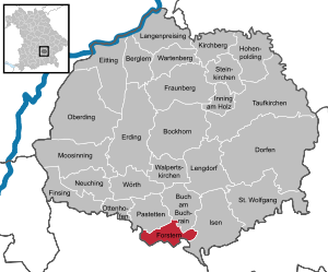
| Location of the municipality of Forstern in the district of Erding | ||
  |
||


Forstern is a municipality in the Upper Bavarian district of Erding .
geography
location
In terms of landscape, the western municipal area lies in the flat Munich gravel plain, which extends to the village of Forstern, while in the east the municipal area merges into a landscaped, wooded and undulating hill country. Forstern is located about 32 km east of the state capital Munich , 15 km south of the district town of Erding , 20 km south-west of Dorfen and 13 km north of Ebersberg . For Munich Airport is 28 km away.
Community structure
The municipality comprises the following parts of the municipality: Forstern, Amplötz, Bocköd, Brand, Hartbrunn, Hub, Karlsdorf, Kipfing, Kreiling, Neuharting, Oberstaudham, Preisendorf, Pullach, Siggenberg, Straßham, Tading, Unterstaudham, Wetting.
history
Until the church is planted
The place name "Forestarin", which has changed over the course of time through some variants such as Vorstarn, Vorstern, Vorstarkn to today's Forstern, appears for the first time in 1065 in the Ebersberger Cartular ( copy book ). The monastery, which was converted into a Jesuit college in 1595, was under two thirds of all properties in Forstern in the 17th century. Forstern belonged to the Munich Rent Office and to the Swabian Regional Court of the Electorate of Bavaria .
The parish Forstern includes not only the districts of the municipality still Reithofen and Harthofen ; the district of Preisendorf belongs to the parish Hohenlinden .
Modern times
In the course of the administrative reforms in Bavaria, today's municipality was created with the municipal edict of 1818. In 1894 the place was hit by a severe cyclone . On May 22, 1962 there was an airplane crash in the district of Amplötz .
Population development
According to the Bavarian State Office for Statistics , the population figures developed as follows on December 31 of each year:
| was standing | Residents |
|---|---|
| 1960 | 1392 |
| 1970 | 1637 |
| 1980 | 1878 |
| 1990 | 2146 |
| 1995 | 2328 |
| 2000 | 2748 |
| was standing | Residents |
|---|---|
| 2005 | 3100 |
| 2006 | 3184 |
| 2007 | 3168 |
| 2008 | 3242 |
| 2009 | 3261 |
| 2010 | 3254 |
| was standing | Residents |
|---|---|
| 2011 | 3213 |
| 2012 | 3345 |
| 2013 | 3415 |
| 2014 | 3491 |
| 2015 | 3592 |
| 2016 | 3662 |
Since 1972, the year of the municipal reform, the population has increased by 1911 until 2015. This corresponds to a growth of 113.68 percent. In the last ten (five) years the population increased by 12.81 (11.80) percent.
Between 1988 and 2018 the municipality grew from 2,071 to 3,717 by 1,646 inhabitants or 79.5%.
politics
mayor
The professional first mayor is Rainer Streu (Old Voting Association Forstern). He has been in office since May 1, 2020. In the mayoral election in 2020 , he prevailed in the runoff election on March 29 with a share of the vote of 66.1 percent.
badges and flags
|
|
Blazon : "In gold a green pole, on both sides a green fir tree with roots, the pole is covered with a growing golden abbot's staff, which is lined with a silver cog in the base."
The coat of arms of the municipality of Forstern was established on May 18, 1953. |
Community finances
The municipal tax revenue in 2016 was 4,135,000 euros, of which 984,000 euros were trade tax revenue (net) and 2,453,000 euros were income tax participation.
Economy and Infrastructure
Industry, trade and commerce
According to official statistics, there were a total of 584 employees subject to social security contributions at the place of work in 2016. Of these, 322 people were employed in the manufacturing sector, 124 in trade, transport and hospitality, 102 in public and private services, 26 in corporate service providers and 10 in agriculture and forestry. 1632 of the inhabitants of the municipality were in employment subject to social insurance contributions. Thus the number of out-commuters outnumbered the in-commuters by 1048. The annual average of 38 people were unemployed.
From 1934 to 1992 the tractor and agricultural machinery manufacturer Eicher was the most important company in Forstern. From 1967 to 1973 Eicher also manufactured trucks for Magirus-Deutz on a contract basis .
Agriculture and Forestry
In 2010 the agricultural area was 998 ha; 785 hectares of which were arable land. 220 hectares of the municipal area are forest, 185 hectares of the municipal area are settlement and traffic areas.
While there were 53 farms in 1999, their number had fallen to 35 by 2010.
| Farm size in ha | Number of establishments | |
|---|---|---|
| 1999 | 2010 | |
| under 5 | 8th | 1 |
| 5 to under 10 | 13 | 9 |
| 10 to under 20 | 11 | 7th |
| 20 to under 50 | 16 | 12 |
| 50 or more | 5 | 6th |
| total | 53 | 35 |
education
In 2017 there were the following institutions:
- Day care centers for children: 5 with 224 places and 200 children, 35 of them under three years of age
- Primary schools: two with 20 teachers and 279 students
Culture and sights
Architectural monuments
Nature reserves
- Erratic block Forstern (geotope number 177R002)
Web links
Individual evidence
- ↑ "Data 2" sheet, Statistical Report A1200C 202041 Population of the municipalities, districts and administrative districts 1st quarter 2020 (population based on the 2011 census) ( help ).
- ↑ a b Mayor / Lord Mayor in municipalities belonging to the district (as of May 1st, 2020). (xlsx) Bavarian State Office for Statistics, accessed on June 20, 2020 .
- ^ Forstern community in the local database of the Bayerische Landesbibliothek Online . Bavarian State Library, accessed on December 29, 2017.
- ↑ 12111-101z census and population update: municipality, population (census and current), reference dates . Bavarian State Office for Statistics; accessed on September 6, 2016.
- ↑ Entry on Forstern's coat of arms in the database of the House of Bavarian History
- ↑ Statistics municipal 2017 - Forstern municipality 09 177 119 - A selection of important statistical data (PDF) Bavarian State Office for Statistics and Data Processing; accessed on April 15, 2018.

Mountain learning | Bockhorn | Buch am Buchrain | Dorfen | Eitting | Erding | Finsing | Forstern | Fraunberg | Hohenpolding | Inning on wood | Isen | Kirchberg | Long price | Lengdorf | Moosinning | Neuching | Oberding | Ottenhofen | Patties | Saint Wolfgang | Stone churches | Taufkirchen (Vils) | Walpert Churches | Wartenberg | Wörth