
District of Kulmbach
| coat of arms | Germany map |
|---|---|

|

Coordinates: 50 ° 5 ' N , 11 ° 24' E |
| Basic data | |
| State : | Bavaria |
| Administrative region : | Upper Franconia |
| Administrative headquarters : | Kulmbach |
| Area : | 658.34 km 2 |
| Residents: | 71,566 (Dec 31, 2019) |
| Population density : | 109 inhabitants per km 2 |
| License plate : | KU, EBS , SAN |
| Circle key : | 09 4 77 |
| NUTS : | DE24B |
| Circle structure: | 22 municipalities |
| Address of the district administration: |
Konrad-Adenauer-Str. 5 95326 Kulmbach |
| Website : | |
| District Administrator : | Klaus Peter Söllner ( FW ) |
| Location of the district of Kulmbach in Bavaria | |
  |
|
The district of Kulmbach is located in the middle of the administrative district of Upper Franconia in Bavaria . The district is a member of the Nuremberg Metropolitan Region .
geography
location
The area of the district of Kulmbach has a share of the Franconian Forest in the northeast, the Fichtelgebirge in the east , the Franconian Switzerland in the southwest and west and the Upper Main Hügelland . The largest rivers in the district are the two source rivers of the Main , the White Main (roughly in the middle of the district) and the Red Main (in the south), which unite to form the Main on the western edge of the city of Kulmbach .
Neighboring areas
The district borders clockwise, beginning in the northwest, on the districts of Kronach , Hof , Bayreuth and Lichtenfels .
history
Regional courts
Before 1800, the area of today's district of Kulmbach belonged mainly to the Principality of Bayreuth (Hohenzollern). In 1810 the area became part of Bavaria. 1804 was the district court Stadtsteinach and 1812, the district court Kulmbach built. Both belonged to the Mainkreis and from 1817 to the Obermainkreis (from 1838 Upper Franconia ). In 1852 the district court of Thurnau was established.
District Offices
The district office of Kulmbach was formed in 1862 through the merger of the district courts of the older order of Kulmbach and Thurnau. At the same time, the Stadtsteinach district office emerged from the regional court of the same name. On the occasion of the reform of the layout of the Bavarian district offices, the Kulmbach district office ceded the municipality of Fesselsdorf to the Lichtenfels district office on January 1, 1880 . On January 1, 1890, the city of Kulmbach left the district office and became a city directly within the district . On January 1, 1902, the community Blaich was assigned to the city of Kulmbach. On October 1, 1929, the communities of Gössenreuth , Himmelkron , Lanzendorf , Marktschorgast , Wasserknoden and Ziegenburg of the disbanded Berneck District Office were incorporated into the Kulmbach District Office.
Counties
On January 1, 1939, as everywhere in the German Reich, the designation district was introduced. The district offices became the districts of Kulmbach and Stadtsteinach. On April 1, 1940, the city of Kulmbach was incorporated into the Kulmbach district, but this was reversed on October 20, 1945.
District of Kulmbach
As part of the regional reform , on July 1, 1972, most of the district of Kulmbach was combined with the urban district of Kulmbach, the district of Stadtsteinach (excluding Markt Seibelsdorf ) and the market Wonsees of the previous district of Ebermannstadt to form the new district of Kulmbach. The city of Kulmbach received the status of a large district town for the loss of district freedom . The communities Neustädtlein am Forst and Wasserknoden moved from the district of Kulmbach to the district of Bayreuth.
On July 1, 1976, the Kulmbach district ceded the Gössersdorf community , which was incorporated into Weißenbrunn, to the Kronach district. On January 1, 1977, the communities of Gösmes and Enchenreuth from the district of Kulmbach were incorporated into the city of Helmbrechts and thus became part of the district of Hof.
Population development

From 1988 to 2008 the district of Kulmbach grew by around 2900 inhabitants (around 4%). However, the trend has been declining again since 2001 after a high of approx. 79,000 inhabitants. In the period from 1988 to 2018, the population decreased from 72,717 to 71,845 by 872 inhabitants or 1.2%. Of the 22 municipalities, 12 had fewer inhabitants in 2018 than 30 years earlier. The following figures refer to the territorial status on May 25, 1987.
| Population development | ||||||||||||||
|---|---|---|---|---|---|---|---|---|---|---|---|---|---|---|
| year | 1840 | 1900 | 1939 | 1950 | 1961 | 1970 | 1987 | 1991 | 1995 | 2000 | 2005 | 2010 | 2015 | |
| Residents | 46,596 | 56,322 | 58,973 | 85,781 | 78,450 | 78,489 | 73.055 | 75,946 | 78,451 | 78,825 | 77.141 | 74,491 | 72,468 | |
politics
District Administrator
- 1947: Adam Sühler ( CSU )
- 1947–1970: Theodor Heublein (community of voters)
- 1970–1984: Kurt Held ( CSU )
- 1984–1996: Herbert Hofmann ( CSU )
- since 1996: Klaus Peter Söllner ( Free Voters )
District council
| CSU | SPD | FW | WG Kulmbach | GREEN / Open List | FDP | AfD | LEFT | total | ||
| 2002 | 22nd | 20th | 10 | 4th | 3 | 1 | 0 | 0 | 60 | |
| 2008 | 23 | 16 | 12 | 3 | 4th | 2 | 0 | 0 | 60 | |
| 2014 | 22nd | 15th | 13 | 4th | 4th | 2 | 0 | 0 | 60 | |
| 2020 | 16 | 9 | 10 | 4th | 5 | 2 | 3 | 1 | 50 |
coat of arms
“By a lowered, curled point, square with black and silver, split by gold and blue; in front a red armored black lion turned to the left, covered with a silver sloping left bar, behind a red armored silver eagle ”.
Economy and Infrastructure
In the Future Atlas 2016, the district of Kulmbach was ranked 268th out of 402 districts, municipal associations and independent cities in Germany and is therefore one of the regions with a "balanced risk-opportunity mix" for the future.
The district of Kulmbach is the third most important food location in Bavaria. 30% of the industrial employees work in this sector (beer, meat / sausage products, baked goods, spices). Kulmbach is a location of the Federal Research Institute for Nutrition and Food, more precisely the Federal Institute for Meat Research. Other important industrial sectors are the textile industry (20% of the industrial employees) and mechanical engineering (12%).
A total of 24,325 employees subject to social security contributions are employed in the district of Kulmbach (as of December 2007).
The most important commercial employers are (as of October 2005):
- IREKS GmbH
- Kulmbach Clinic
- Kulmbacher Brewery AG
- Sparkasse Kulmbach-Kronach
- Raps GmbH & Co. KG
- ait-deutschland GmbH (former Alpha Innotec GmbH)
- Franken Maxit Mauermörtel GmbH & Ko. KG and Kalkwerk Joh. Bergmann KG
- Glen Dimplex Germany GmbH
- MAJA Möbelwerke AG
- Printing company Töpfer Kulmbach GmbH
traffic
In 1846 the Ludwig-Süd-Nord-Bahn came from Lichtenfels via Kulmbach upstream to the Neuenmarkt-Wirsberg station and in 1846, despite the technical difficulties, including the inclined plane , crossed the ridges of the Fichtelgebirge to the end point Hof an der Saale. From Neuenmarkt-Wirsberg, Bayreuth was connected to the rail network in 1853 by the Bayreuth – Neuenmarkt-Wirsberg railway.
This was only slightly enlarged by the Bavarian State Railways at the turn of the century and reached a circumference of 84 kilometers with the following local railways :
- 1896: Neuenmarkt-Wirsberg-Lanzendorf-Bischofsgrün
- 1908: Kulmbach – Thurnau (1909 further to Bayreuth)
- 1913: Untersteinach – Stadtsteinach
It was later reduced by half, i.e. by 42 kilometers:
- 1956: Untersteinach – Stadtsteinach 5 km
- 1973: Thurnau – Aichen – Bayreuth 12 km
- 1974: Neuenmarkt-Wirsberg-Lanzendorf-Bischofsgrün 9 km
- 1993: Kulmbach – Thurnau 16 km
Motorways 9 and 70 as well as federal highways 85 , 289 and 303 run through the district .
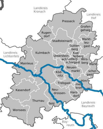
Communities
(Residents on December 31, 2019)
Cities
Markets
Other communities
|
Administrative communities
  |
Municipalities of the district before the territorial reform 1971/1978
Before the regional reform, the district of Kulmbach had 57 municipalities (see list below). (The churches that still exist today are written in bold ):
| former parish | today's parish | today's district |
|---|---|---|
| Alladorf | Thurnau | District of Kulmbach |
| Azendorf | Kasendorf | District of Kulmbach |
| Berndorf | Thurnau | District of Kulmbach |
| Little bridge | Neudrossenfeld | District of Kulmbach |
| Buchau | Mainleus | District of Kulmbach |
| Burghaig | Kulmbach | District of Kulmbach |
| Danndorf | Mainleus | District of Kulmbach |
| Dollnitz | Kasendorf | District of Kulmbach |
| Felkendorf | Thurnau | District of Kulmbach |
| Gössenreuth | Sky crown | District of Kulmbach |
| Harsdorf | Harsdorf | District of Kulmbach |
| Hegnabrunn | Neuenmarkt | District of Kulmbach |
| Lovely | Kasendorf | District of Kulmbach |
| Sky crown | Sky crown | District of Kulmbach |
| Courtier | Kulmbach | District of Kulmbach |
| Hutschdorf | Thurnau | District of Kulmbach |
| Kasendorf | Kasendorf | District of Kulmbach |
| Katschenreuth | Kulmbach | District of Kulmbach |
| Kauernburg 1 | Kulmbach | District of Kulmbach |
| Kauerndorf | Ködnitz | District of Kulmbach |
| Parish church | Kulmbach | District of Kulmbach |
| Ködnitz | Ködnitz | District of Kulmbach |
| Langenstadt | Neudrossenfeld | District of Kulmbach |
| Lanzendorf | Sky crown | District of Kulmbach |
| Lehenthal | Kulmbach | District of Kulmbach |
| Leuchau | Kulmbach | District of Kulmbach |
| Limmersdorf | Thurnau | District of Kulmbach |
| Lindau | Trebgast | District of Kulmbach |
| Losau | Kulmbach | District of Kulmbach |
| Lop | Kasendorf | District of Kulmbach |
| Mainleus | Mainleus | District of Kulmbach |
| Mangersreuth 1 | Kulmbach | District of Kulmbach |
| Marktschorgast | Marktschorgast | District of Kulmbach |
| Melkendorf | Kulmbach | District of Kulmbach |
| Menchau | Thurnau | District of Kulmbach |
| Metzdorf 1 | Kulmbach | District of Kulmbach |
| Muckenreuth | Neudrossenfeld | District of Kulmbach |
| Neudrossenfeld | Neudrossenfeld | District of Kulmbach |
| Neuenmarkt | Neuenmarkt | District of Kulmbach |
| Neuenreuth am Main | Neudrossenfeld | District of Kulmbach |
| New catch | Wirsberg | District of Kulmbach |
| Neustädtlein am Forst | Eckersdorf | Bayreuth district |
| Oberdornlach | Kulmbach | District of Kulmbach |
| Pitch pit | Neudrossenfeld | District of Kulmbach |
| Peesten | Kasendorf | District of Kulmbach |
| Pross | Mainleus | District of Kulmbach |
| Sanspareil | Wonsees | District of Kulmbach |
| Schimmendorf | Mainleus | District of Kulmbach |
| Schirradorf | Wonsees | District of Kulmbach |
| Schmeilsdorf | Mainleus | District of Kulmbach |
| Schwarzach near Kulmbach | Mainleus | District of Kulmbach |
| Tannfeld | Thurnau | District of Kulmbach |
| Thurnau | Thurnau | District of Kulmbach |
| Trebgast | Trebgast | District of Kulmbach |
| Veitlahm | Mainleus | District of Kulmbach |
| Water balls | Bad Berneck in the Fichtel Mountains | Bayreuth district |
| Wernstein | Mainleus | District of Kulmbach |
| Willmersreuth | Mainleus | District of Kulmbach |
| Wirsberg | Wirsberg | District of Kulmbach |
| Goat castle | Marktschorgast | District of Kulmbach |
1 April 1, 1946 to the city of Kulmbach
Protected areas
In the district of Kulmbach there are four nature reserves , 14 landscape protection areas , 21 FFH areas and 49 designated geotopes . (As of August 2016)
See also:
- List of nature reserves in the district of Kulmbach
- List of landscape protection areas in the district of Kulmbach
- List of FFH areas in the district of Kulmbach
- List of geotopes in the district of Kulmbach
License Plate
On July 1, 1956, the district was assigned the distinctive sign KU when the vehicle registration number that is still valid today was introduced. It is still issued today. Since July 10, 2013 SAN (Stadtsteinach) and EBS (Ebermannstadt) have also been available due to the license plate liberalization .
literature
- Rüdiger Barth: Kulmbach: City and Altlandkreis (= Historical Atlas of Bavaria, part of Franconia . I, 38). Commission for Bavarian State History, Munich 2012, ISBN 978-3-7696-6554-3 .
- August Gebeßler : City and district of Kulmbach (= Bavarian art monuments . Volume 3 ). Deutscher Kunstverlag, Munich 1958, DNB 451450973 .
- Erich Freiherr von Guttenberg : Land and city district of Kulmbach (= historical book of place names of Bavaria, Upper Franconia . Volume 1 ). Commission for Bavarian State History, Munich 1952, DNB 451738918 .
Web links
- Entry on the coat of arms of the district of Kulmbach in the database of the House of Bavarian History
- A tour through the archeology of the Kulmbacher Land in the Obermain Landscape Museum
- Literature from and about the district of Kulmbach in the catalog of the German National Library
- District of Kulmbach: Official statistics of the LfStat
- District Office Kulmbach
Individual evidence
- ↑ "Data 2" sheet, Statistical Report A1200C 202041 Population of the municipalities, districts and administrative districts 1st quarter 2020 (population based on the 2011 census) ( help ).
- ^ Wilhelm Volkert (ed.): Handbook of Bavarian offices, communities and courts 1799–1980 . CH Beck, Munich 1983, ISBN 3-406-09669-7 , p. 503 .
- ^ Announcement on the dissolution of the Berneck District Office from September 21, 1929
- ^ Amendment to the notice on the dissolution of the Berneck District Office from October 18, 1929
- ^ Wilhelm Volkert (ed.): Handbook of Bavarian offices, communities and courts 1799–1980 . CH Beck, Munich 1983, ISBN 3-406-09669-7 , p. 97 .
- ^ Ordinance on the reorganization of Bavaria into rural districts and independent cities of December 27, 1971
- ↑ a b Bavarian State Office for Statistics and Data Processing
- ↑ Kulmbach district - overall result
- ↑ Future Atlas 2016. (No longer available online.) Archived from the original on October 2, 2017 ; accessed on March 23, 2018 . Info: The archive link was inserted automatically and has not yet been checked. Please check the original and archive link according to the instructions and then remove this notice.
- ↑ "Data 2" sheet, Statistical Report A1200C 202041 Population of the municipalities, districts and administrative districts 1st quarter 2020 (population based on the 2011 census) ( help ).
- ↑ - ( Memento of the original from June 11, 2011 in the Internet Archive ) Info: The archive link was inserted automatically and has not yet been checked. Please check the original and archive link according to the instructions and then remove this notice.

Independent cities: Amberg | Ansbach | Bamberg | Bayreuth | Coburg | Erlangen | Fürth | Yard | Nuremberg | Schwabach | Willows in the Upper Palatinate
Districts: District of Amberg-Sulzbach | District of Ansbach | Bamberg district | Bayreuth district | District of Coburg | District of Erlangen-Höchstadt | Forchheim district | Fürth district | District of Haßberge | District of Kitzingen | District of Kronach | District of Kulmbach | District of Lichtenfels | District of Neumarkt idOPf. | District Neustadt adAisch-Bad Windsheim | District Neustadt ad Waldnaab | District of Nürnberger Land | District of Roth | District of Sonneberg | District of Tirschenreuth | Weißenburg-Gunzenhausen district | District of Wunsiedel in the Fichtel Mountains
Districts:
Aichach-Friedberg |
Altötting |
Amberg-Sulzbach |
Ansbach |
Aschaffenburg |
Augsburg |
Bad Kissingen |
Bad Toelz-Wolfratshausen |
Bamberg |
Bayreuth |
Berchtesgadener Land |
Cham |
Coburg |
Dachau |
Deggendorf |
Dillingen on the Danube |
Dingolfing-Landau |
Danube Ries |
Ebersberg |
Eichstätt |
Erding |
Erlangen-Höchstadt |
Forchheim |
Freising |
Freyung-Grafenau |
Fürstenfeldbruck |
Fürth |
Garmisch-Partenkirchen |
Gunzburg |
Hatred Mountains |
Yard |
Kelheim |
Kitzingen |
Kronach |
Kulmbach |
Landsberg am Lech |
Landshut |
Lichtenfels |
Lindau (Lake Constance) |
Main-Spessart |
Miesbach |
Miltenberg |
Mühldorf am Inn |
Munich |
Neuburg-Schrobenhausen |
Neumarkt in the Upper Palatinate |
Neustadt an der Aisch-Bad Windsheim |
Neustadt an der Waldnaab |
Neu-Ulm |
Nuremberg Country |
Oberallgäu |
Ostallgäu |
Passau |
Pfaffenhofen an der Ilm |
Rain |
Regensburg |
Rhön-Grabfeld |
Rosenheim |
Roth |
Rottal-Inn |
Schwandorf |
Schweinfurt |
Starnberg |
Straubing Arch |
Tirschenreuth |
Traunstein |
Unterallgäu |
Weilheim-Schongau |
Weißenburg-Gunzenhausen |
Wunsiedel in the Fichtel Mountains |
Wurzburg
Independent cities:
Amberg |
Ansbach |
Aschaffenburg |
Augsburg |
Bamberg |
Bayreuth |
Coburg |
Erlangen |
Fürth |
Hof (Saale) |
Ingolstadt |
Kaufbeuren |
Kempten (Allgäu) |
Landshut |
Memmingen |
Munich |
Nuremberg |
Passau |
Regensburg |
Rosenheim |
Schwabach |
Schweinfurt |
Straubing |
Willows in the Upper Palatinate |
Wurzburg