
Rottal-Inn district
| coat of arms | Germany map |
|---|---|

|

Coordinates: 48 ° 25 ' N , 12 ° 52' E |
| Basic data | |
| State : | Bavaria |
| Administrative region : | Lower Bavaria |
| Administrative headquarters : | Parish churches |
| Area : | 1,281.42 km 2 |
| Residents: | 121,502 (Dec. 31, 2019) |
| Population density : | 95 inhabitants per km 2 |
| License plate : | PAN, EG, GRI, VIB |
| Circle key : | 09 2 77 |
| NUTS : | DE22A |
| Circle structure: | 31 municipalities |
| Address of the district administration: |
Ringstrasse 4-5 84347 Pfarrkirchen |
| Website : | |
| District Administrator : | Michael Fahmüller ( CSU ) |
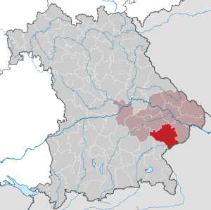
| Location of the Rottal-Inn district in Bavaria | |
  |
|

The district of Rottal-Inn is located in the south of the Bavarian administrative district of Lower Bavaria .
geography
location
According to the natural spatial structure, the district mainly belongs to the Isar-Inn-Hügelland . The river Rott flows through the district in a west-east direction and divides it into two almost equally large parts. The Inn forms the border with Austria.
Neighboring areas
The district borders in a clockwise direction in the southwest on the districts Altötting , Mühldorf am Inn , Landshut , Dingolfing-Landau , Deggendorf and Passau . In the south it borders on the Upper Austrian district of Braunau am Inn .
history
The district area belonged to the former Viztumamt an der Rott, an administrative organization of the Lower Bavarian dukes in the 13th and 14th centuries, whose seat was the parish church market. It included the possessions of the Count Palatine von Spanheim acquired in 1260.
Regional courts
In 1803 the district courts of Pfarrkirchen and Simbach am Inn as well as Eggenfelden were established. They belonged to the Lower Danube District , which was renamed Lower Bavaria in 1838 . Between 1810 and 1816 the Simbach court was united with Braunau .
District Offices
In 1862, the district courts Pfarrkirchen and Simbach am Inn formed the district office Pfarrkirchen and the district courts Eggenfelden and Arnstorf the district office Eggenfelden, whereby the district court Arnstorf was newly established from communities of the district courts Eggenfelden, Landau an der Isar and parish churches.
Counties
On January 1, 1939, the designation district was introduced as everywhere else in the German Reich . So the district offices became the districts of Eggenfelden and parish churches.
With a few exceptions, the end of World War II was comparatively light. On May 1, 1945, the 13th Armored Division (Black Cat Division) , which came from Plattling in a one-day march, occupied almost the entire district. While the occupation in the vast majority of places, including the towns of Eggenfelden and Pfarrkirchen, took place without the use of weapons, especially in Malgersdorf and Falkenberg there were hours of firefights in which heavy weapons were used. There were dead and injured, houses burned, and the churches in both places were badly damaged. In addition, on that day the German Wehrmacht blew up the road and railway bridge over the Inn between Simbach and Braunau in order to slow down the Russian pursuers. A special event took place in Tann : The Hungarian army command , which had fled from the Red Army together with their staff , and which also included the defense minister and the prime minister, capitulated to US Major General Millikin on the market square. The area around Gangkofen and Massing was then occupied on May 2nd. Even during the war, the rural population took in homeless people from the major German cities destroyed by the bombing. In 1945 many more expellees from the former German eastern regions and Sudeten Germans joined them. Many of them stayed here, integrated themselves and made a significant contribution to the reconstruction and recovery in the post-war period.
In 1946 the first provisional county order was enacted by the American military government . Based on this, the district administrator was elected freely by the population for the first time in 1952.
Rottal-Inn district
As part of the regional reform in Bavaria , a new district was formed on July 1, 1972 from the district of Pfarrkirchen and the district of Eggenfelden (with the exception of five communities) as well as two communities each of the former districts of Griesbach and Vilsbiburg , which was initially called the district of Rottal . The seat of the district administration was parish churches. On May 1, 1973, it was renamed "Rottal-Inn District".
Population development
The Rottal-Inn district gained around 14,000 residents between 1988 and 2008, or grew by 13%. From 2004 to 2011 the trend was in decline. Between 1988 and 2018 the district grew from 104,613 to 120,659 by 16,046 inhabitants or by 15.3%.
The following figures refer to the territorial status on May 25, 1987.
| Population development | ||||||||||||||
|---|---|---|---|---|---|---|---|---|---|---|---|---|---|---|
| year | 1840 | 1900 | 1939 | 1950 | 1961 | 1970 | 1987 | 1991 | 1995 | 2000 | 2005 | 2010 | 2015 | |
| Residents | 60,298 | 75,578 | 85,660 | 121,734 | 100,700 | 101,863 | 104.013 | 109,911 | 115.281 | 118.167 | 119,598 | 117,952 | 119.218 | |
Economy and Infrastructure
The district does not have any large industrial structures, but the companies in the southeast Bavarian chemical triangle are not far away. The economy is structured more like a medium-sized company.
Agriculture (especially horse breeding) traditionally played a very important role in the district. The number of farms fell drastically from 1974 to 2006 from around 9,700 to 3,500 and continues to decrease.
Tourism plays a role especially in Bad Birnbach , the "rural bath", which has experienced an upswing since the first thermal water drilling in 1973.
traffic
railroad
Simbach was the first town in the district to be connected to the cross-border main line Munich – Braunau of the Royal Bavarian State Railways in 1871 with the Simbach train station . The Passau – Neumarkt-Sankt Veit line has crossed the district since 1879 , with the most important stations being Pfarrkirchen, Eggenfelden and Bad Birnbach.
The market town of Gangkofen was touched by the Mühldorf – Pilsting railway line opened in 1875 by the AG der Bayerische Ostbahnen .
The Bavarian State Railways added two local railways to the network after the turn of the century : one reached Markt Arnstorf from Landau in 1903, and the Simbach – Pocking line ran from Simbach downwards in 1910 towards Tutting - Pocking.
On more than a third of the 85 km of the network, passenger traffic was suspended as follows:
- 1964: Landau - Ruppertskirchen - Arnstorf (5 km)
- 1969: Tutting - Ering - Simbach (12 km)
- 1969/70: Pilsting - Gangkofen - Neumarkt-St. Veit (12 km)
All public transport in the district is organized in the Rottal-Inn transport association.
Streets
The Rottal-Inn district has several transport links that are important for the region: The A 94 is being planned , which will connect Munich through Rottal-Inn with the A 3 at Pocking . The B 20 and the B 388 will then be used as feeders for the A94 . The current B 12 roughly corresponds to the traffic routing that the A 94 will later adopt.
Airfields
In the Rottal-Inn district, the Eggenfelden airfield (1160 m × 23 m-SL-Bahn), the Pfarrkirchen airfield and the Kirchdorf am Inn special airfield are available for air traffic.
politics

In Bundestag elections , the rural-conservative constituency is one of the regional strongholds of the CSU in Bavaria .
District administrators
| Term of office | Surname | Political party | annotation |
|---|---|---|---|
| July 1, 1972-1983 | Ludwig Mayer | CSU | Husband of Bruni Mayer; 1983 suspended by the district government . |
| 1983 - April 1984 | Oskar Seitz | CSU | acting district administrator |
| May 1984 - November 30, 1987 | Josef Poisl | FWG | Deputy for Ludwig Mayer |
| November 30, 1987 - November 29, 2011 | Bruni Mayer | UWG | |
| since November 30, 2011 | Michael Fahmüller | CSU |
Michael Fahmüller (CSU) won the district election on October 23, 2011.
MPs: The district is represented by Martin Wagle (CSU) in the Bavarian state parliament. Directly elected member of the Bundestag has been Max Straubinger (CSU) since 1994 . On the list of SPD came Florian Pronold 2002 in the Bundestag.
coat of arms
|
|
Blazon : “Divided into silver and gold by a narrow, blue sloping beam pointing to the left; above a fire-breathing red panther trunk, below a rising red horse directed to the left. " |
| Justification of the coat of arms: The two animals symbolize the two predecessor districts Pfarrkirchen and Eggenfelden. The panther also appears in the coat of arms of the city of Eggenfelden and refers to the Counts of Sponheim, whose descendants once ruled the former district of Eggenfelden. The horse was chosen for the coat of arms of the Pfarrkirchen district in 1961 because the area is known for its horse breeding. In 1896, the first horse racing track in southern Germany was opened there. The blue sloping bar refers to the Rott, which divides the district into two almost identical parts. |
Communities


(Residents on December 31, 2019)
|
Other communities
|
Protected areas
There are two nature reserves , nine landscape protection areas , five FFH areas and at least 21 geotopes designated by the Bavarian State Office for the Environment (as of April 2016) in the district.
See also
- List of nature reserves in the Rottal-Inn district
- List of landscape protection areas in the Rottal-Inn district
- List of FFH areas in the Rottal-Inn district
- List of geotopes in the Rottal-Inn district
License Plate
On 5 August 1974 the district was the since July 1, 1956 valid for the county parishes distinguishing sign PAN assigned. It is still issued today. Since July 10, 2013, the license plate liberalization has also made the distinguishing marks EG (Eggenfelden), GRI (Bad Griesbach im Rottal) and VIB (Vilsbiburg) available.
See also
literature
- Martin Ortmeier: The most beautiful farmhouses in the Rottal. Evidence of the rural past. SüdOst-Verlag, Waldkirchen 2002, ISBN 3-89682-073-7 .
- Erich Eder, Adolf Hochholzer: The district of Rottal-Inn. Neue Presse Verlags-GmbH, Passau 1975, DNB 770528805 .
Web links
- Literature from and about the Rottal-Inn district in the catalog of the German National Library
- Entry on the coat of arms of the Rottal-Inn district in the database of the House of Bavarian History
Individual evidence
- ↑ "Data 2" sheet, Statistical Report A1200C 202041 Population of the municipalities, districts and administrative districts 1st quarter 2020 (population based on the 2011 census) ( help ).
- ^ Wilhelm Volkert (ed.): Handbook of Bavarian offices, communities and courts 1799–1980 . CH Beck, Munich 1983, ISBN 3-406-09669-7 , p. 97 .
- ↑ Jaromír Balcar: Politics in the countryside: studies on the Bavarian province 1945 to 1972 , Oldenburgverlag
- ↑ Entry on the coat of arms of the Rottal-Inn district in the database of the House of Bavarian History , accessed on September 5, 2017 .
- ↑ "Data 2" sheet, Statistical Report A1200C 202041 Population of the municipalities, districts and administrative districts 1st quarter 2020 (population based on the 2011 census) ( help ).
Districts:
Aichach-Friedberg |
Altötting |
Amberg-Sulzbach |
Ansbach |
Aschaffenburg |
Augsburg |
Bad Kissingen |
Bad Toelz-Wolfratshausen |
Bamberg |
Bayreuth |
Berchtesgadener Land |
Cham |
Coburg |
Dachau |
Deggendorf |
Dillingen on the Danube |
Dingolfing-Landau |
Danube Ries |
Ebersberg |
Eichstätt |
Erding |
Erlangen-Höchstadt |
Forchheim |
Freising |
Freyung-Grafenau |
Fürstenfeldbruck |
Fürth |
Garmisch-Partenkirchen |
Gunzburg |
Hatred Mountains |
Yard |
Kelheim |
Kitzingen |
Kronach |
Kulmbach |
Landsberg am Lech |
Landshut |
Lichtenfels |
Lindau (Lake Constance) |
Main-Spessart |
Miesbach |
Miltenberg |
Mühldorf am Inn |
Munich |
Neuburg-Schrobenhausen |
Neumarkt in the Upper Palatinate |
Neustadt an der Aisch-Bad Windsheim |
Neustadt an der Waldnaab |
Neu-Ulm |
Nuremberg Country |
Oberallgäu |
Ostallgäu |
Passau |
Pfaffenhofen an der Ilm |
Rain |
Regensburg |
Rhön-Grabfeld |
Rosenheim |
Roth |
Rottal-Inn |
Schwandorf |
Schweinfurt |
Starnberg |
Straubing Arch |
Tirschenreuth |
Traunstein |
Unterallgäu |
Weilheim-Schongau |
Weißenburg-Gunzenhausen |
Wunsiedel in the Fichtel Mountains |
Wurzburg
Independent cities:
Amberg |
Ansbach |
Aschaffenburg |
Augsburg |
Bamberg |
Bayreuth |
Coburg |
Erlangen |
Fürth |
Hof (Saale) |
Ingolstadt |
Kaufbeuren |
Kempten (Allgäu) |
Landshut |
Memmingen |
Munich |
Nuremberg |
Passau |
Regensburg |
Rosenheim |
Schwabach |
Schweinfurt |
Straubing |
Willows in the Upper Palatinate |
Wurzburg