
Mitterskirchen
| coat of arms | Germany map | |
|---|---|---|

|
Coordinates: 48 ° 21 ' N , 12 ° 44' E |
|
| Basic data | ||
| State : | Bavaria | |
| Administrative region : | Lower Bavaria | |
| County : | Rottal Inn | |
| Height : | 433 m above sea level NHN | |
| Area : | 24.67 km 2 | |
| Residents: | 2155 (Dec. 31, 2019) | |
| Population density : | 87 inhabitants per km 2 | |
| Postal code : | 84335 | |
| Area code : | 08725 | |
| License plate : | PAN, EG, GRI, VIB | |
| Community key : | 09 2 77 134 | |
| LOCODE : | DE MTC | |
| Community structure: | 37 districts | |
| Address of the municipal administration: |
Hofmarkstrasse 17 84335 Mitterskirchen |
|
| Website : | ||
| Mayor : | Christian Müllinger ( CSU ) | |
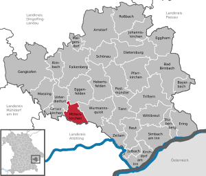
| Location of the municipality of Mitterskirchen in the Rottal-Inn district | ||
  |
||

Mitterskirchen is a municipality in the Rottal-Inn district in Lower Bavaria .

geography
Geographical location
Mitterskirchen is located in the Landshut region in a small, gentle side valley of the Rott on the border with Upper Bavaria . Mitterskirchen is located directly on the B 588 about 7 km southwest of Eggenfelden , 18 km north of Altötting , 23 km northeast of Mühldorf and 22 km southwest of the district town of Pfarrkirchen . The next train station on the Passau - Mühldorf route is in Eggenfelden.
Community structure
Mitterskirchen has 37 districts:
|
There are the districts Hirschhorn, Mitterskirchen and Hammersbach.
history
Until the 19th century
It can be assumed that the name Mitterskirchen resulted from the geographical location between two other church locations. The first settlement activities can be found there as early as the 8th century.
Mitterskirchen was first mentioned in a document in 1156 under the name "Miterenchirchen". Later it received the legal status of an undecided Hofmark.
At the site of today's parish church there was a castle chapel of the noble von Mitterskirchen until the 14th century. The church was renovated in the 16th century. In the entrance area of the church is the grave slab of the last noble von Mitterskirchen, Heimeran von Haunsperg and his wife from the 16th century. In 1849 the church tower was renewed and the nave was later extended. The originally neo-Gothic furnishings of the parish church were replaced by neo-baroque altars.
Mitterskirchen belonged to the Landshut Rent Office and the Eggenfelden Regional Court of the Electorate of Bavaria . The baroness Maria Anna von Ingenheim , née von Closen zu Gern and Arnstorf, owned an open Hofmark here around 1800 . In the course of the administrative reforms in Bavaria , today's municipality was created with the municipal edict of 1818 .
20th century
The community suffered great hardship in both world wars. Between 1914 and 1918 a total of 38 men from the village community died, during the Second World War 59 people from Mitterskirchen were killed. On May 1, 1945, Mitterskirchen was hit by tanks of the US Army. The Allies advanced via Hofau and Eggenfelden to Mitterskirchen and assumed that a group of members of the SS had stayed here. Several buildings were damaged by tank shells, including the church tower of the parish church.

On January 1, 1972, part of the Hirschhorn community was incorporated. On May 1, 1978, the smaller part of the dissolved community Hammersbach was added. Despite vigorous protests, the Mitterskirchen community was incorporated into the Wurmannsquick administrative community in 1978. The mayors Franz Seidl and Martin Eder and the municipal councils made several applications to the Bavarian state government in order to maintain independence. On January 1, 1994, the community finally regained its independence.
In the post-war years there was lively settlement activity, as a result of which the town center developed through the Rothneichnersiedlung towards Atzberg. In 1990 the Geradfeldsiedlung and in 2001 the settlement area "Am Sonnenhang" was developed. With the increasing number of inhabitants, the infrastructure of the community also had to be increased considerably.
Population development
Between 1988 and 2019 the municipality grew from 1,656 to 2,125 by 469 inhabitants or by 28.3%.
| year | Residents | year | Residents |
|---|---|---|---|
| 1961 | 1,394 | 1970 | 1,453 |
| 1987 | 1,612 | 1991 | 1,732 |
| 2000 | 2,087 | 2020 | 2.125 |
In 2019, the proportion of people under the age of 18 was 18.6%, and that of those over 65 was 18.1%.
politics
Christian Müllinger (CSU / Heimatblock) has been mayor since May 2014.
A partnership with the Upper Austrian municipality of Mitterkirchen im Machland has existed since 1978 .
coat of arms
The municipal coat of arms, which has been in use since 1976, integrates with the counter battlements and the notched bars the family coat of arms of the lords of Haunsperg, who were raised to the rank of count in 1660, which is handed down in a plastic representation in the parish church. The silver wavy bar refers to the geographic location of the municipality in the wide valley floor of the Gera.
Blazon : Divided by red and silver; at the top a silver counter pinnacle bar covered with a blue wavy bar, at the bottom slanted and left slanted notched blue bars.


Architectural monuments
Economy and Infrastructure
Economy including agriculture and forestry
According to official statistics, there were six employees at the place of work in the field of agriculture and forestry, 175 in the manufacturing sector and nine in the trade and transport sector. In other economic sectors, 43 people were employed at the place of work subject to social security contributions. There were a total of 661 employees at the place of residence subject to social insurance contributions. There were two companies in the manufacturing sector and six in the construction sector. In addition, in 1999 there were 87 farms with an agriculturally used area of 1574 ha, of which 998 ha were arable land and 576 ha were permanent green space.
The outdoor swimming pool, the Stockschützenhalle, the gymnasium and the sports stadium are available for leisure activities.
education
- Kindergarten: 75 kindergarten places
- Elementary schools: In 1988 a new school building for the elementary and middle schools was built. The school was enlarged by an extension in 2004/2005.
Culture and sights
theatre
The Dorfbühne Mitterskirchen was founded in 1994 and maintains high-quality popular theater.
Club life
- ESV Mitterskirchen
- Horticultural Association Mitterskirchen
- Friends of the Mitterskirchen elementary school
- Dorfbühne Mitterskirchen eV
- Ski club (SC) Mitterskirchen
- Arbinger Hof eV
- Men's Congregation Mitterskirchen
- Mitterskirchen volunteer fire department
- Catholic women's association Mitterskirchen
- Traditional costume club
- Catholic rural youth Mitterskirchen
- FC Bayern Munich fan club Die Rote Lederhosen eV
- Mitterskirchen water rescue service
Individual evidence
- ↑ "Data 2" sheet, Statistical Report A1200C 202041 Population of the municipalities, districts and administrative districts 1st quarter 2020 (population based on the 2011 census) ( help ).
- ^ Community Mitterskirchen in the local database of the Bavarian State Library Online . Bayerische Staatsbibliothek, accessed on January 4, 2018.
- ^ Wilhelm Volkert (ed.): Handbook of Bavarian offices, communities and courts 1799–1980 . CH Beck, Munich 1983, ISBN 3-406-09669-7 , p. 455 .
- ^ Federal Statistical Office (ed.): Historical municipality directory for the Federal Republic of Germany. Name, border and key number changes in municipalities, counties and administrative districts from May 27, 1970 to December 31, 1982 . W. Kohlhammer GmbH, Stuttgart / Mainz 1983, ISBN 3-17-003263-1 , p. 629 .
- ^ House of Bavarian History - Bavaria's municipalities. Retrieved February 14, 2019 .
Web links
- Entry on the coat of arms of Mitterskirchen in the database of the House of Bavarian History
- Mitterskirchen: Official statistics of the LfStat (PDF; 1.24 MB)

Arnstorf | Bad Birnbach | Bayerbach | Dietersburg | Eggenfelden | Egglham | Ering | Falkenberg | Gangkofen | Geratskirchen | Hebertsfelden | Johanniskirchen | Julbach | Kirchdorf am Inn | Malgersdorf | Massing | Mitterskirchen | Parish churches | Postmünster | Reut | Rimbach | Rossbach | Schönau | Simbach am Inn | Stubenberg | Tann | Triftern | Unterdietfurt | Wittibreut | Wurmannsquick | Zeilarn