
Rimbach (Rottal-Inn district)
| coat of arms | Germany map | |
|---|---|---|

|
Coordinates: 48 ° 28 ' N , 12 ° 39' E |
|
| Basic data | ||
| State : | Bavaria | |
| Administrative region : | Lower Bavaria | |
| County : | Rottal Inn | |
| Management Community : | Falkenberg | |
| Height : | 454 m above sea level NHN | |
| Area : | 22.92 km 2 | |
| Residents: | 908 (Dec. 31, 2019) | |
| Population density : | 40 inhabitants per km 2 | |
| Postal code : | 84326 | |
| Area code : | 08727 | |
| License plate : | PAN, EG, GRI, VIB | |
| Community key : | 09 2 77 141 | |
| Community structure: | 36 districts | |
| Address of the municipal administration: |
Kirchplatz 6 (Rattenbach) 84326 Rimbach |
|
| Website : | ||
| Mayor : | Otto Fisch ( CSU / Free Community of Voters ) | |
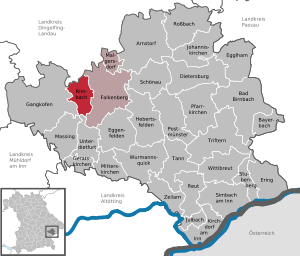
| Location of the municipality of Rimbach in the Rottal-Inn district | ||
  |
||


Rimbach is a municipality in the Lower Bavarian district of Rottal-Inn and a member of the Falkenberg administrative community .
geography
Geographical location
Rimbach is located in the Landshut region in the typical Lower Bavarian hilly landscape about eleven kilometers northwest of Eggenfelden , 26 km east of Vilsbiburg , 29 km south of Dingolfing and 24 km west of the district town of Pfarrkirchen . The federal highways 20 and 388 are only a few kilometers away from Rimbach; the two nearest train stations are in Massing and Eggenfelden (each eleven kilometers away) on the regional railway line Passau – Mühldorf .
Community structure
Rimbach has 36 districts:
There are the districts of Rimbach and Sallach.
history
Until the church is planted
The Rimbach monastery dates back to the Agilolfinger era and was thus one of the original monasteries in Bavaria . It was entered on a map in the 9th century as Rindpah , belonging to the Passau monastery . Rimbach later belonged to the Landshut Rent Office and the Eggenfelden district court of the Electorate of Bavaria . In the course of the administrative reforms in Bavaria , the municipality of Rimbach was created with the municipal edict of 1818 .
Incorporations
On January 1, 1946, the municipality of Sallach was briefly incorporated into Rimbach, but on December 29, 1947 it was independent again. On May 1, 1978 part of this municipality came to Rimbach as part of the regional reform in Bavaria . In 1981 the districts of Oberrohrbach and Wimpersing were added to the dissolved community of Haberskirchen .
Population development
Between 1988 and 2018, the community grew from 835 to 923 by 88 inhabitants or 10.5%.
- 1961: 869 inhabitants
- 1970: 836 inhabitants
- 1987: 837 inhabitants
- 1991: 853 inhabitants
- 1995: 865 inhabitants
- 2000: 866 inhabitants
- 2005: 902 inhabitants
- 2010: 860 inhabitants
- 2015: 897 inhabitants
politics
Otto Fisch (CSU) has been mayor since May 2014.
coat of arms
Blazon : In silver from blue three-mountain, in it a flying silver dove, growing a green fir tree with golden cones.
Culture and sights
- Lanz Museum Mitterrohrbach
- Filial church St. Laurentius in Rimbach. The core of the early Gothic complex was converted to Baroque style in the 18th century .
Economy including agriculture and forestry
Jobs
In 2017, according to official statistics, there were 71 employees subject to social security contributions at the place of work. 327 employees at the place of residence subject to social security contributions were registered. Five residents were unemployed.
Agriculture
The number of farms has decreased from 72 in 2003 to 48 in 2016. 1867 hectares of the communal corridor were used for agriculture in 2016, 1619 hectares of which were arable land and 247 hectares of permanent green space. The forest area was 502 ha.
Personalities
- Leonhard "Leo" Speer, called " Lanz-Leo " (1941–2016), founder and operator of the Lanz Museum Mitterrohrbach
Individual evidence
- ↑ "Data 2" sheet, Statistical Report A1200C 202041 Population of the municipalities, districts and administrative districts 1st quarter 2020 (population based on the 2011 census) ( help ).
- ^ Municipality of Rimbach in the local database of the Bavarian State Library Online . Bayerische Staatsbibliothek, accessed on January 5, 2018.
- ^ Federal Statistical Office (ed.): Historical municipality directory for the Federal Republic of Germany. Name, border and key number changes in municipalities, counties and administrative districts from May 27, 1970 to December 31, 1982 . W. Kohlhammer GmbH, Stuttgart / Mainz 1983, ISBN 3-17-003263-1 , p. 629 .
- ^ House of Bavarian History - Bavaria's municipalities. Retrieved February 14, 2019 .
Web links
- Entry on the coat of arms of Rimbach (Rottal-Inn district) in the database of the House of Bavarian History
- Rimbach (Rottal-Inn district): Official statistics of the LfStat (PDF; 1.24 MB)

Arnstorf | Bad Birnbach | Bayerbach | Dietersburg | Eggenfelden | Egglham | Ering | Falkenberg | Gangkofen | Geratskirchen | Hebertsfelden | Johanniskirchen | Julbach | Kirchdorf am Inn | Malgersdorf | Massing | Mitterskirchen | Parish churches | Postmünster | Reut | Rimbach | Rossbach | Schönau | Simbach am Inn | Stubenberg | Tann | Triftern | Unterdietfurt | Wittibreut | Wurmannsquick | Zeilarn