Unterdietfurt
| coat of arms | Germany map | |
|---|---|---|

|
Coordinates: 48 ° 23 ' N , 12 ° 39' E |
|
| Basic data | ||
| State : | Bavaria | |
| Administrative region : | Lower Bavaria | |
| County : | Rottal Inn | |
| Height : | 420 m above sea level NHN | |
| Area : | 27.53 km 2 | |
| Residents: | 2089 (Dec. 31, 2019) | |
| Population density : | 76 inhabitants per km 2 | |
| Postal code : | 84339 | |
| Primaries : | 08724, 08721 | |
| License plate : | PAN, EG, GRI, VIB | |
| Community key : | 09 2 77 151 | |
| Community structure: | 29 districts | |
| Address of the municipal administration: |
Dorfplatz 10 84339 Unterdietfurt |
|
| Website : | ||
| Mayor : | Bernhard Blümelhuber (Voting Community Huldsessen and Surroundings) | |
| Location of the community of Unterdietfurt in the Rottal-Inn district | ||

Unterdietfurt is a municipality in the Rottal-Inn district in Lower Bavaria .
geography
Geographical location
Unterdietfurt is located in the Landshut region in the Rott valley, not far from the B 388 and on the Passau – Mühldorf regional train line , the nearest train station of which is in Massing, 4 km away . Unterdietfurt is located about 8 km west of Eggenfelden , 22 km north of Altötting , 25 km northeast of Mühldorf , 27 km southeast of Vilsbiburg and 23 km from the district town of Pfarrkirchen .
Community structure
Unterdietfurt has 29 districts:
|
There are districts Unterdietfurt and Huldsessen.
history
Until the church is planted
It was mentioned in a document as early as the 8th century. The Upper and Lower Dietfurt emerged from the original parish of Dietfurt. Today Oberdietfurt is part of the Massing market . Unterdietfurt belonged to the Landshut Rent Office and the Eggenfelden district court of the Electorate of Bavaria. In the course of the administrative reforms in Bavaria, today's municipality was created with the municipal edict of 1818. In the 19th century, grain growing and livestock were the main branches of business. A total of 146 people lost their lives in the two world wars.
21st century
In 2011 a new town hall was built.
Incorporations
With the regional reform in Bavaria on January 1, 1972, Huldsessen came to the municipality of Unterdietfurt. However, it was separated again on May 1, 1978 and partly came to Eggenfelden and Falkenberg. Unterdietfurt entered into an administrative partnership with the communities of Massing and Geratskirchen. In 1983 the separation of Huldsessen was lifted by the Bavarian Administrative Court and Huldsessen came back to Unterdietfurt. Finally, Unterdietfurt stepped out of the administrative community with Massing and Geratskirchen in 1986.
Population development
Between 1988 and 2018 the municipality grew from 1,852 to 2,091 by 239 inhabitants or by 12.9%.
- 1961: 2095 inhabitants
- 1970: 1968 inhabitants
- 1987: 1844 inhabitants
- 1991: 1935 inhabitants
- 1995: 1987 inhabitants
- 2000: 2093 inhabitants
- 2005: 2122 inhabitants
- 2010: 2090 inhabitants
- 2015: 2079 inhabitants
politics
Bernhard Blümelhuber (Voting Community Huldsessen and the surrounding area) has been the honorary first mayor since May 1, 2020. His predecessor Richard Schneider (Free Voting Community) was in office for the three terms of office from 2002 to 2020. Until 2002 Josef Münch (Free Association of Voters) was the first mayor.
coat of arms
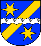
Blazon : In blue a golden oblique left bar, covered by a silver wave bar, above and below a six-pointed golden star.
Culture and sights
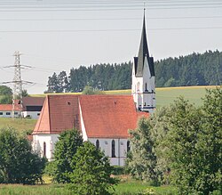
The parish church of the Visitation of Mary , built in 1441, has a late Gothic winged altar around 1500. Some tombstones date from the 15th and 16th centuries.
Economy and Infrastructure
Economy including agriculture and forestry
According to official statistics, there were 15 employees at the place of work in the field of agriculture and forestry, 146 in the manufacturing sector and 48 in trade and transport. In other economic areas, 52 people were employed at the place of work subject to social security contributions. There were a total of 682 employees at the place of residence subject to social security contributions. There were four companies in the manufacturing sector and three in the construction sector. In addition, in 1999 there were 91 farms with an agricultural area of 1854 hectares, of which 1393 hectares were arable land.
education
There are the following facilities:
- Kindergartens: 75 kindergarten places with 66 children (as of 1999)
- Pfarrer Reindl Primary School: 73 children in 3 classes (as of 2017)
- Community library
Individual evidence
- ↑ "Data 2" sheet, Statistical Report A1200C 202041 Population of the municipalities, districts and administrative districts 1st quarter 2020 (population based on the 2011 census) ( help ).
- ^ Community Unterdietfurt in the local database of the Bavarian State Library Online . Bayerische Staatsbibliothek, accessed on January 5, 2018.
- ↑ https://www.unterdietfurt.de/gemeindeinfo/geschichte/geschichte-ab-1850/
- ^ Wilhelm Volkert (ed.): Handbook of Bavarian offices, communities and courts 1799–1980 . CH Beck, Munich 1983, ISBN 3-406-09669-7 , p. 455 .
- ^ Federal Statistical Office (ed.): Historical municipality directory for the Federal Republic of Germany. Name, border and key number changes in municipalities, counties and administrative districts from May 27, 1970 to December 31, 1982 . W. Kohlhammer GmbH, Stuttgart / Mainz 1983, ISBN 3-17-003263-1 , p. 630 .
- ^ House of Bavarian History - Bavaria's municipalities. Retrieved February 14, 2019 .
Web links
- Entry on the coat of arms of Unterdietfurt in the database of the House of Bavarian History
- Unterdietfurt: Official statistics of the LfStat (PDF; 1.24 MB)


