
Rott (Inn, Neuhaus am Inn)
| Red | ||
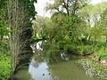
 The Rott - Frimhöring near Ruhstorf |
||
| Data | ||
| Water code | EN : 188 | |
| location |
Lower Bavarian hill country
Lower Bavaria |
|
| River system | Danube | |
| Drain over | Inn → Danube → Black Sea | |
| source | Müllerthann (municipality of Wurmsham ) 48 ° 20 ′ 59 ″ N , 12 ° 21 ′ 0 ″ E |
|
| Source height | approx. 472 m above sea level NN | |
| muzzle | from the left at Neuhaus am Inn and across from the Austrian Schärding in the Inn Coordinates: 48 ° 27 '12 " N , 13 ° 25' 32" E 48 ° 27 '12 " N , 13 ° 25' 32" E |
|
| Mouth height | approx. 301 m above sea level NN | |
| Height difference | approx. 171 m | |
| Bottom slope | approx. 1.5 ‰ | |
| length | 111.4 km | |
| Catchment area | 1,200.01 km² | |
| Discharge at the Ruhstorf A Eo gauge: 1,051.55 km² Location: 11.4 km above the mouth |
NNQ MNQ 1965/2007 MQ 1965/2007 Mq 1965/2007 MHQ 1965/2007 HHQ (08/03/1991) |
1.29 m³ / s 3.33 m³ / s 9.31 m³ / s 8.9 l / (s km²) 124 m³ / s 295 m³ / s |
| Discharge at the mouth of the A Eo : 1,200.01 km² |
MQ Mq |
10.7 m³ / s 8.9 l / (s km²) |
| Left tributaries | Bina , Sulzbach | |
| Right tributaries | Geratskirchner Bach , Grasenseer Bach , Altbach | |
| Reservoirs flowed through | Rottauensee | |
The Rott is a 111 km long river in Lower Bavaria and on an upper section also Upper Bavaria . After a largely eastern course, it flows into the lower Inn at Neuhaus am Inn in the Passau district and opposite the Upper Austrian town of Schärding with an average water flow of 10.7 m³ / s from the left .
etymology
The document forms of the river name, "ad Rota" (769) and "flumen qui dictur Rota" (773), as well as the dialect form Roud refer to an etymon "Rotaha", which means something like "red brook".
geography
course
The Rott is created near Müllerthann in the municipality of Wurmsham in the Landshut district at around 472 m above sea level. NN a small wooded swamp and runs her first half a dozen kilometers approximately southeast, where she soon changes over the municipal boundary into the district of Mühldorf am Inn .
At Oberbergkirchen it then takes up the first, not very small, tributary, the Ritzinger Bach , and then flows more east-northeast in the direction of its inflow. It crosses the town of Neumarkt-Sankt Veit , after which it runs towards the lower district boundary to increasingly east. After crossing into the Rottal-Inn district , the Bina soon flows from the north-west at Markt Massing , and then further east and down in the town of Eggenfelden from the south-west of the Geratskirchner Bach . A little before the district town of Pfarrkirchen , it passes through the Rottauensee near Postmünster . After the settlement area of the city, the Grasenseer Bach runs in turn from the southwest and soon afterwards the Altbach flows into the area around Markt Bad Birnbach in about the same direction .
Further down, the Rott runs into the southern district of Passau and there passes Pocking on your right and then the Markt Ruhstorf an der Rott on the other side. The Sulzbach , the lowest of its larger tributaries, flows on its last three kilometers . Just above the municipality of Neuhaus am Inn on the Bavarian bank and opposite the Upper Austrian town of Schärding, it flows into the Inn from the left, only 16 km above its own confluence with the Danube .
The Rott rises at about 472 m above sea level. NN , has a length of about 111.4 km and flows out at about 301 m above sea level. NN , with which it has a mean gradient of around 1.5 ‰.
From the source to the district border near Massing , the Rott is a body of water III. Order , then a second order water body, from the confluence of the Bina to the confluence with the Inn finally a first order water body.

Catchment area
The Rott drains 1200 km² in Upper and especially Lower Bavaria in an easterly direction towards the Inn. Its catchment area extends eastwards about 83 km from the source of the Ritzinger Bach near Wurmsham to the mouth; across it it is a maximum of 19 km wide. In the north-west and north it borders on the Vils running to the Danube , in the north-east the smaller Wolfach and some streams to the Danube flow beyond its border, and finally to the receiving Inn . From the mouth in the east to the southeast to the middle south, several small to very small streams run towards the Inn, which runs parallel here, the largest of which is the Kößlarner Bach . In the southwest, the Isen competes near and roughly parallel to the Inn.
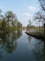
The Rott at Massing

The Bina (right) flows into the Rott
The Rott near Oberdietfurt

_M%C3%BCndung_in_die_Rott.JPG)

Neighborhoods
in the order of first contact.
- Administrative region of Lower Bavaria
-
Landshut district
- Wurmsham parish
-
Landshut district
- Administrative region of Upper Bavaria
-
District of Mühldorf am Inn
- Community Oberbergkirchen
- Community of Schönberg
- community Lohkirchen
- City of Neumarkt-Sankt Veit (main town on the river)
-
District of Mühldorf am Inn
- Administrative region of Lower Bavaria
-
Rottal-Inn district
- Markt Massing (main town on the river)
- Unterdietfurt municipality (main town on the river)
- City of Eggenfelden (main town on the river)
- Hebertsfelden municipality (main town on the river)
- Municipality Postmünster (the main town on the river)
- City of Pfarrkirchen (main town on the river)
- Bad Birnbach market
- Market Triftern
- Bayerbach municipality (main town on the river)
-
District of Passau
- Rotthalmünster market
- City of Bad Griesbach im Rottal
- municipality Tettenweis
- City of Pocking
- Market Ruhstorf an der Rott (main town on the river)
- Municipality Neuhaus am Inn
-
Rottal-Inn district

Flood
In earlier times, the Rott floods caused great damage, around 1954. Therefore, a retention basin was created near Postmünster , in which it is dammed up to the Rottauensee lake, which is over 50 hectares in size, when the flood retention is up to 3 km².
Web links
- Course of the Rott on the BayernAtlas
Individual evidence
- ↑ a b Height according to the contour line image on: BayernAtlas of the Bavarian State Government ( information ) - detail map .
- ↑ a b List of brook and river areas in Bavaria - Inn river area, page 83 of the Bavarian State Office for the Environment, as of 2016 (PDF; 2.8 MB)
- ↑ Ruhstorf gauge ( memento of the original from November 9, 2014 in the Internet Archive ) Info: The archive link was automatically inserted and not yet checked. Please check the original and archive link according to the instructions and then remove this notice. Bayerischer Hochwassernachrichtendienst, on: hnd.bayern.de, accessed on February 21, 2013
- ↑ Level value Ruhstorf increased by the area runoff (9.8 l / s.km²) of the remaining catchment area (150.91 km²). The area runoff corresponds to that of the Ruhstorf gauge . The drainage of the enclosing, 3344.4 km² level intermediate catchment area is 12.8 l / s.km² (level Ruhstorf , Wasserburg (Inn), Altenmarkt (Alz), Stein bei Altenmarkt (Traun), Burghausen (Salzach), Jahrsdorf ( Mattig), Mamling (Ach), Pramerdorf (Pram) and Passau-Ingling (Inn)).