
Hebertsfelden
| coat of arms | Germany map | |
|---|---|---|

|
Coordinates: 48 ° 24 ' N , 12 ° 49' E |
|
| Basic data | ||
| State : | Bavaria | |
| Administrative region : | Lower Bavaria | |
| County : | Rottal Inn | |
| Height : | 405 m above sea level NHN | |
| Area : | 49.89 km 2 | |
| Residents: | 3653 (Dec. 31, 2019) | |
| Population density : | 73 inhabitants per km 2 | |
| Postal code : | 84332 | |
| Area code : | 08721 | |
| License plate : | PAN, EG, GRI, VIB | |
| Community key : | 09 2 77 124 | |
| LOCODE : | DE EXE | |
| Community structure: | 152 districts | |
| Address of the municipal administration: |
Bahnhofstrasse 1 84332 Hebertsfelden |
|
| Website : | ||
| First Mayor : | Karin Kienböck-Stöger | |
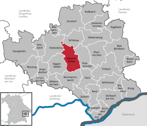
| Location of the municipality of Hebertsfelden in the Rottal-Inn district | ||
  |
||


Hebertsfelden is a municipality in the Rottal-Inn district in Lower Bavaria .
geography
The community is located in southern Lower Bavaria in the tertiary hill country on the upper reaches of the Rott between the towns of Eggenfelden and Pfarrkirchen.
Community structure
There are 152 districts:
There are the districts Hebertsfelden, Langeneck, Linden, Lohbruck, Unterhausbach, Gern and Peterskirchen.
history
Until the church is planted
Hebertsfelden was first notarized around 1073 when an Adalprecht de Heriboldesfelden signed as a benefactor. In the period from 1220 to 1240 the Hochstift Freising attested possessions in the place. In the 17th and 18th centuries, Hebertsfelden consisted of around 20 properties. At the beginning of the 19th century it became a separate municipality.
Incorporations
On January 1, 1946, Hebertsfelden received parts of the communities of Langeneck and Gern II, but the merger was reversed with effect from January 1, 1948. Only through the municipal reform in Bavaria was on 1 January 1972 by connecting the communities Linden, House of Bach and the remnants of the communities Langeneck and gladly II and the inclusion of parts of the dissolved communities Lohbruck and Peter Churches (to 29 January 1952, the community name Peterskirchen I ) formed today's community on May 1, 1978.
Population development
Between 1988 and 2019 the community grew from 3492 to 3820 by 328 inhabitants.
politics
mayor
The honorary first mayor is Karin Kienböck-Stöger (non-party voter community). She has been in office since May 1, 2020. In the mayoral election in 2020, she achieved a share of 70.1 percent of the vote in the second ballot.
coat of arms
|
|
Blazon : “Above a split corrugated shield base in confused colors split by silver and blue; a red lance and a fallen red sword crossed diagonally in front, a silver linden tree in the back. " |
Economy and Infrastructure
According to official statistics, there were 15 employees at the place of work in the field of agriculture and forestry, 384 in the manufacturing sector and 57 in trade and transport. In other economic sectors 144 people were employed at the place of work subject to social security contributions. There were a total of 1242 employees at the place of residence subject to social security contributions. There was 1 company in the manufacturing sector and 11 companies in the construction sector. In addition, in 1999 there were 164 farms with an agricultural area of 3366 ha, of which 2358 ha were arable land and 1008 ha were permanent green space.
traffic
Hebertsfelden has a stop on the Passau – Neumarkt – Sankt Veit railway line .
education
The following institutions exist (as of: 1999):
- Kindergartens: 100 kindergarten places with 111 children
- Primary and secondary school: one with 19 teachers and 260 students
Sports
In the Hebertsfelden community there are extensive opportunities for sporting activities.
- Sports club Hebertsfelden (football, tennis, stick shooting, gymnastics, Nordic walking)
- Gollerbach sports club (women's, girls and men's soccer)
Sights and buildings
- Parish church of St. Emmeram, built 1859–1862 according to plans by Leonhard Schmidtner .
- Side church St. Jakob in Rottenstuben, built in the middle of the 15th century, in 1958 well-preserved frescoes were found in the choir, which were probably created around 1500.
- Parish churches St. Philippus and Jakobus, Niedernkirchen, 15th century, extended in 1911.
- Local history museum next to the town hall, in the building of the former brickworks.
- Ground monuments, such as jumps from the Celtic and Hungarian times.
Personalities
- Ludwig Gruber (1922–2005), poet, called Ponzauner Wigg
Web links
- Herbertsfelden community
- Hebertsfelden: Official statistics of the LfStat (PDF; 1.2 MB)
Individual evidence
- ↑ "Data 2" sheet, Statistical Report A1200C 202041 Population of the municipalities, districts and administrative districts 1st quarter 2020 (population based on the 2011 census) ( help ).
- ^ Municipality of Hebertsfelden in the local database of the Bayerische Landesbibliothek Online . Bayerische Staatsbibliothek, accessed on January 5, 2018.
- ^ Wilhelm Volkert (ed.): Handbook of Bavarian offices, communities and courts 1799–1980 . CH Beck, Munich 1983, ISBN 3-406-09669-7 , p. 455 .
- ^ Federal Statistical Office (ed.): Historical municipality directory for the Federal Republic of Germany. Name, border and key number changes for municipalities, counties and administrative districts from May 27, 1970 to December 31, 1982 . W. Kohlhammer GmbH, Stuttgart / Mainz 1983, ISBN 3-17-003263-1 , p. 629 .
- ↑ Mayor / Lord Mayor in municipalities belonging to the district (as of May 1st, 2020). (xlsx) Bavarian State Office for Statistics, accessed on June 20, 2020 .
- ^ Entry on the coat of arms of Hebertsfelden in the database of the House of Bavarian History

Arnstorf | Bad Birnbach | Bayerbach | Dietersburg | Eggenfelden | Egglham | Ering | Falkenberg | Gangkofen | Geratskirchen | Hebertsfelden | Johanniskirchen | Julbach | Kirchdorf am Inn | Malgersdorf | Massing | Mitterskirchen | Parish churches | Postmünster | Reut | Rimbach | Rossbach | Schönau | Simbach am Inn | Stubenberg | Tann | Triftern | Unterdietfurt | Wittibreut | Wurmannsquick | Zeilarn