Schönau (Rottal)
| coat of arms | Germany map | |
|---|---|---|

|
Coordinates: 48 ° 29 ' N , 12 ° 51' E |
|
| Basic data | ||
| State : | Bavaria | |
| Administrative region : | Lower Bavaria | |
| County : | Rottal Inn | |
| Height : | 428 m above sea level NHN | |
| Area : | 36.12 km 2 | |
| Residents: | 1948 (Dec. 31, 2019) | |
| Population density : | 54 inhabitants per km 2 | |
| Postal code : | 84337 | |
| Area code : | 08726 | |
| License plate : | PAN, EG, GRI, VIB | |
| Community key : | 09 2 77 144 | |
| Community structure: | 53 districts | |
| Address of the municipal administration: |
Bachhamerstr. 22 84337 Schönau |
|
| Website : | ||
| Mayor : | Robert Putz | |
| Location of the community of Schönau in the Rottal-Inn district | ||
Schönau is a community in the Rottal-Inn district in Lower Bavaria .
geography
Geographical location
Schönau is located in the Landshut region in the middle of the typically Lower Bavarian hilly landscape away from major traffic routes. The village of Schönau is located about eleven kilometers northwest of the district town of Pfarrkirchen , twelve kilometers northeast of Eggenfelden , 30 km south of Landau and 35 km southwest of Vilshofen . The nearest train station on the Passau - Mühldorf regional train line is in Hebertsfelden, ten kilometers away .
Community structure
Schönau has 53 districts:
There are the districts Schönau, Unterzeitlarn and Unterhöft .
history
Until the 19th century
Schönau belonged to the Barons Riederer von Paar . The place was part of the Electorate of Bavaria and formed a closed Hofmark , whose seat was Schönau. In the course of the administrative reforms in Bavaria , the municipal edict of 1818 created the municipalities of Schönau I and Schönau II. Schönau I included the locations Schönau, Attenberg and Hastetten, Schönau II the locations Aicha (the municipal seat of Schönau II), Aign, Eggmühl, Fiding, Figling, Haselbach, Hastetten, Haunprechting, Holz, Hurm, Kaltenbrunn, Ortprechting and Schachten. The baronial von Riederer'sche Patrimonialgericht Schönau existed in Germany until the revolution of 1848/1849 .
Incorporations
The community of Schönau was created on January 1, 1972 through the merger of the previously independent communities of Schönau I, Schönau II and Unterzeitlarn (until January 29, 1952 Peterskirchen II ) and parts of the area of Unterhöft.
Population development
Between 1988 and 2018 the municipality grew from 1,564 to 1,935 by 371 inhabitants or 23.7%.
- 1961: 1,661 inhabitants, of which 530 from Schönau I, 176 from Schönau II, 453 from Unterzeitlarn and 502 from Unterhöft
- 1970: 1565 inhabitants, of which 524 from Schönau I, 170 from Schönau II, 425 from Unterzeitlarn and 446 from Unterhöft
- 1987: 1540 inhabitants
- 1991: 1701 inhabitants
- 1995: 1797 inhabitants
- 2000: 1942 inhabitants
- 2005: 2038 inhabitants
- 2010: 1972 inhabitants
- 2015: 1973 inhabitants
politics
Mayor is Robert Putz. In 2014 he succeeded Edigna Keneder (CSU / Party Free).
coat of arms
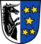
Blazon : split by silver and blue; in front a black unicorn torso turned to the left, in the back five, two to one to two, five-pointed golden stars.
Culture and sights
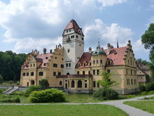
- Moated Castle Schönau : A medieval moated castle that was rebuilt by Gabriel von Seidl from 1899–1900 . The palace park was laid out in 1870 based on a design by Carl von Effner .
- The neo-Gothic single-nave parish church of St. Stephan was built in 1890/1891 according to plans by Johann Baptist Schott . Only the choir, integrated as a side chapel on the east side, remained from the previous late Gothic building. The baroque altar was made around 1680 and shows life-size carved figures of St. Joseph and St. George and on the altar sheet the stoning of St. Stephen.
Economy and Infrastructure
Economy including agriculture and forestry
In 1998, according to official statistics, there were 13 employees in the field of agriculture and forestry, 33 in the manufacturing sector and 17 in the field of trade and transport. In other economic sectors 42 people were employed at the place of work subject to social security contributions. There were a total of 594 employees at the place of residence subject to social insurance contributions. There was one company in the manufacturing sector and two companies in the construction sector. In addition, there were 101 agricultural holdings in 1999 with an agriculturally used area of 2288 ha, of which 1683 ha were arable land and 603 ha were permanent green space.
The old inn "Oberwirt" remains from what were once several bars and inns. A new café has been built next to the church .
Within the municipality - three kilometers from the main town - the Voglsam leisure center was built. A variety of activities are offered there, including a. Mini and swing golf , karting and ballooning , trampoline jumping and tobogganing .
education
In 1999 the following institutions existed:
- Kindergartens: 50 kindergarten places with 71 children
- Elementary schools: one with seven teachers and 177 students
Individual evidence
- ↑ "Data 2" sheet, Statistical Report A1200C 202041 Population of the municipalities, districts and administrative districts 1st quarter 2020 (population based on the 2011 census) ( help ).
- ^ Community Schönau in the local database of the Bayerische Landesbibliothek Online . Bayerische Staatsbibliothek, accessed on March 7, 2018.
- ^ Wilhelm Volkert (ed.): Handbook of Bavarian offices, communities and courts 1799–1980 . CH Beck, Munich 1983, ISBN 3-406-09669-7 , p. 455 .
- ^ House of Bavarian History - Bavaria's municipalities. Retrieved February 14, 2019 .
- ^ Passauer Neue Presse: Hunting scenes in the Rottal: Runaway young cattle captured safely . In: Eggenfelden - News - Newspaper - Rottaler Anzeiger . ( pnp.de [accessed on July 8, 2018]).
Web links
- Entry on the coat of arms of Schönau (Rottal) in the database of the House of Bavarian History
- Schönau (Rottal): Official statistics of the LfStat (PDF; 1.24 MB)


