Johanniskirchen
| coat of arms | Germany map | |
|---|---|---|

|
Coordinates: 48 ° 32 ' N , 12 ° 57' E |
|
| Basic data | ||
| State : | Bavaria | |
| Administrative region : | Lower Bavaria | |
| County : | Rottal Inn | |
| Height : | 367 m above sea level NHN | |
| Area : | 40.59 km 2 | |
| Residents: | 2517 (Dec. 31, 2019) | |
| Population density : | 62 inhabitants per km 2 | |
| Postal code : | 84381 | |
| Area code : | 08564 | |
| License plate : | PAN, EG, GRI, VIB | |
| Community key : | 09 2 77 126 | |
| LOCODE : | DE JON | |
| Community structure: | 45 districts | |
| Address of the municipal administration: |
Obere Hauptstrasse 1 84381 Johanniskirchen |
|
| Website : | ||
| Mayor : | Max Maier ( FWG ) | |
| Location of the community Johanniskirchen in the Rottal-Inn district | ||
Johanniskirchen is a municipality in the Rottal-Inn district in Lower Bavaria . The parish village of the same name is the main town of the community.
geography
Geographical location
Johanniskirchen is located in the Landshut region in the valley of the Sulzbach , a southern tributary of the Vils . The village of Johanniskirchen is located about 13 km north of the district town of Pfarrkirchen , 18 km northwest of Bad Birnbach , 23 km southwest of Vilshofen , 24 km south of Osterhofen and 32 km southeast of Landau . The nearest train station is in Pfarrkirchen.
Community structure
There are 45 common parts:
- Ammersdorf
- Apfelbach
- Railway fence
- Bockenbach
- fire
- Brunndobl
- Then slaughter
- Dummeldorf
- Eggersdorf
- Emmersdorf
- Erlbach
- Fabach
- Gerbersdorf
- Gietzering
- Guteneck
- Habach
- Haibach
- Haidendorf
- Johanniskirchen
- Karlsweiler
- Kraham
- Krohstorf
- Lapperding
- Lengham
- Lousy
- Mödlsbach
- Oberstadl
- Riegeröd
- Sarzen
- Schaföd
- Schornbach
- Schratzmühle
- Schuhöd
- Schwaig
- Schwaigeröd
- Solla
- Stockham
- Stroblöd
- Unterbubach
- Lower Adl
- Pond
- Wieglöd
- Windbaising
- Windfurth
- Wolfstriegl
Markings are Dummeldorf, Emmersdorf and Johanniskirchen.
history
Until the church is planted
Johanniskirchen first appeared in documents in 1130 as a secular parish free episcopal collation (bestowed). Johanniskirchen belonged to the Landshut Rent Office and the Parish Churches Regional Court of the Electorate of Bavaria . In the course of the administrative reforms in Bavaria , today's municipality was created with the municipal edict of 1818 .
Incorporations
The community of Dummeldorf was incorporated in 1946. Oberstadl was added on January 1, 1972 from the former municipality of Mitterhausen . The municipality of Emmersdorf followed on July 1, 1972.
Population development
Between 1988 and 2018 the community grew from 2,321 to 2,521 inhabitants or by 8.6%.
- 1961: 2315 inhabitants
- 1970: 2288 inhabitants
- 1987: 2335 inhabitants
- 1991: 2428 inhabitants
- 1995: 2468 inhabitants
- 2000: 2486 inhabitants
- 2005: 2458 inhabitants
- 2010: 2449 inhabitants
- 2015: 2447 inhabitants
politics
The honorary first mayor is Max Maier (Free Voters). He has been in office since May 1, 2014.
coat of arms
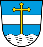
| Blazon : "Above a silver wave shield foot in blue a silver bar, covered by a growing golden cross staff." | |
Economy and Infrastructure
Handicrafts (wood, metal) in particular are widespread in Johanniskirchen. But many services are also offered (hairdressers, insurance). The basic supply is secured by many shops.
There are four volunteer fire brigades (Johanniskirchen, Emmersdorf, Mödlsbach, Unterbubach), two schools (secondary and elementary school), a kindergarten, two general practitioners and a dentist. In Johanniskirchen-Schornbach there is the healing-customer-center of the psychotherapist and esotericist Ruediger Dahlke .
There are bus connections to Eggenfelden, Pfarrkirchen and sometimes to Arnstorf.
Clubs offer a wide range of leisure activities.
Economy including agriculture and forestry
In 1998, according to official statistics, there were no employees at work subject to social security contributions in the manufacturing industry or in trade and transport. In other economic sectors there were 69 people. There were 856 employees at the place of residence subject to social security contributions. There were none in manufacturing and eight in the construction industry. In addition, in 1999 there were 151 agricultural holdings with an agriculturally used area of 2158 ha, of which 1471 ha were arable land.
education
In 1999 the following institutions existed:
- Kindergartens: 75 kindergarten places with 63 children
- Primary schools: two with 21 teachers and 292 students
- Library (as of 2017)
Attractions
- The parish churches in Johanniskirchen and Emmersdorf and the pilgrimage church in Guteneck
- The town hall in Johanniskirchen
- A geotope is located in the old gravel pit in Kraham (coordinates: 48 ° 31 ′ 5 ″ N, 12 ° 56 ′ 41 ″ E).
Web links
- Johanniskirchen parish
- Johanniskirchen: Official statistics of the LfStat (PDF; 1.24 MB)
Individual evidence
- ↑ "Data 2" sheet, Statistical Report A1200C 202041 Population of the municipalities, districts and administrative districts 1st quarter 2020 (population based on the 2011 census) ( help ).
- ^ Community Johanniskirchen in the local database of the Bavarian State Library Online . Bayerische Staatsbibliothek, accessed on January 5, 2018.
- ↑ Bavarian State Office for Statistics and Data Processing (Hrsg.): The municipalities of Bavaria according to the territorial status May 25, 1987. The population of the municipalities of Bavaria and the changes in the acquisitions and territory from 1840 to 1987 (= contributions to Statistics Bavaria . Issue 451). Munich 1991, p. 68–69 , urn : nbn: de: bvb: 12-bsb00070717-7 ( digitized version - Rottal-Inn district; footnotes 1 and 11).
- ^ Wilhelm Volkert (ed.): Handbook of Bavarian offices, communities and courts 1799–1980 . CH Beck, Munich 1983, ISBN 3-406-09669-7 , p. 455 .
- ↑ Greetings from the mayor. Johanniskirchen parish, accessed on August 26, 2020 .
- ^ Entry on the coat of arms of Johanniskirchen in the database of the House of Bavarian History


