Egglham
| coat of arms | Germany map | |
|---|---|---|

|
Coordinates: 48 ° 32 ' N , 13 ° 4' E |
|
| Basic data | ||
| State : | Bavaria | |
| Administrative region : | Lower Bavaria | |
| County : | Rottal Inn | |
| Height : | 353 m above sea level NHN | |
| Area : | 36.83 km 2 | |
| Residents: | 2364 (Dec. 31, 2019) | |
| Population density : | 64 inhabitants per km 2 | |
| Postal code : | 84385 | |
| Area code : | 08543 | |
| License plate : | PAN, EG, GRI, VIB | |
| Community key : | 09 2 77 117 | |
| Community structure: | 58 districts | |
| Address of the municipal administration: |
Main street 33 84385 Egglham |
|
| Website : | ||
| Mayor : | Hermann Etzel ( CSU / FWG) | |
| Location of the municipality of Egglham in the Rottal-Inn district | ||
Egglham is a municipality in the Rottal-Inn district in Lower Bavaria .
geography
Geographical location
The community is located in the Landshut region about 16 km northeast of the district town of Pfarrkirchen , 18 km southwest of Vilshofen , 32 km northwest of Pocking and 40 km west of Passau . Egglham is on the edge of the Bavarian Tuscany (Lower Rottal), the Klosterwinkel and the Holzland in the typical Lower Bavarian hilly landscape.
Community structure
There are 58 districts:
There are the districts of Amsham and Egglham.
Neighboring communities
Neighboring towns are Aidenbach , Beutelsbach, Haarbach , Dietersburg and Bad Birnbach and a little further away Bad Füssing , Bad Griesbach im Rottal , Pfarrkirchen , Eggenfelden , Passau , Schärding ( Upper Austria ) and Vilshofen on the Danube .
history
Until the church is planted
Egglham belonged to the Burghausen Rent Office and the Vilshofen Regional Court of the Electorate of Bavaria . The Counts of Ortenburg , who have been owners of property and bailiwick rights in the Egglham area since 1210, had an open court here . Egglham was first mentioned in a document in 1140. In the course of the administrative reforms in Bavaria , today's municipality was created with the municipal edict of 1818 .
Incorporations
On October 1, 1971, the previously independent community of Amsham was incorporated.
Population development
Between 1988 and 2018 the municipality grew from 2,283 to 2,376 by 93 inhabitants or 4.1%.
- 1961: 2262 inhabitants
- 1970: 2270 inhabitants
- 1987: 2298 inhabitants
- 1991: 2394 inhabitants
- 1995: 2421 inhabitants
- 2000: 2442 inhabitants
- 2005: 2415 inhabitants
- 2010: 2370 inhabitants
- 2015: 2369 inhabitants
politics
Mayor is Hermann Etzel (CSU / FWG). In 2012 he succeeded Michael Fahmüller (CSU), who was elected district administrator in autumn 2011. Fahmüller's predecessor was Adolf Feilmeier ( SPD ) until 2002 .
coat of arms
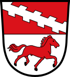
Blazon : Shared by red and silver, above gegenästiger, silver inclined beams, below trotting to the left, black armored, red horse.
Attractions
The parish church of St. Stephen is a late Gothic complex. The nave was extended in 1771. The two aisles were built between 1860 and 1870.
Economy and Infrastructure
Economy including agriculture and forestry
In 1998, according to official statistics, there were five employees in the field of agriculture and forestry, 174 in the manufacturing sector and 18 in the trade and transport sector at the place of work. In other economic sectors 37 people were employed at the place of work subject to social security contributions. There were a total of 768 employees at the place of residence subject to social security contributions. There were none in manufacturing and five in construction. In addition, in 1999 there were 115 farms with an agriculturally used area of 2277 ha, of which 1754 ha were arable land and 519 ha were permanent green space.
education
There are the following educational institutions:
- the Egglham kindergarten with currently 54 children. In 2010/2011 it was completely renovated and expanded to include a day nursery.
- Since September 2010, after 40 years there has been an independent primary school with a single gym, the Egglham primary school. Opened in 2010 as one of the most modern schools in the district.
Personalities
- Peter Griesbacher (1864–1933), church composer, lecturer at the church music school in Regensburg
Web links
- Egglham parish
- Egglham: Official statistics of the LfStat (PDF; 1.24 MB)
Individual evidence
- ↑ "Data 2" sheet, Statistical Report A1200C 202041 Population of the municipalities, districts and administrative districts 1st quarter 2020 (population based on the 2011 census) ( help ).
- ↑ Greetings from the mayor. Egglham parish, accessed June 11, 2020 .
- ^ Community Egglham in the local database of the Bavarian State Library Online . Bayerische Staatsbibliothek, accessed on January 5, 2018.
- ↑ A short chronicle of the Egglham community. Egglham parish, accessed June 11, 2020 .
- ^ Wilhelm Volkert (ed.): Handbook of Bavarian offices, communities and courts 1799–1980 . CH Beck, Munich 1983, ISBN 3-406-09669-7 , p. 552 .
- ^ House of Bavarian History - Bavaria's municipalities. Retrieved February 14, 2019 .
- ^ Homepage of the Egglham Kindergarten
- ^ Homepage of the Egglham primary school


