
District of Griesbach im Rottal
| coat of arms | Germany map | |
|---|---|---|

|
Coordinates: 48 ° 27 ' N , 13 ° 12' E |
|
| Basic data (as of 1972) | ||
| Existing period: | 1862-1972 | |
| State : | Bavaria | |
| Administrative region : | Lower Bavaria | |
| Administrative headquarters : | Griesbach im Rottal | |
| Area : | 493.32 km 2 | |
| Residents: | 42,900 (Dec. 31, 1972) | |
| Population density : | 87 inhabitants per km 2 | |
| License plate : | GRI | |
| Circle key : | 09 2 36 | |
| Circle structure: | 36 municipalities | |
| Address of the district administration: |
8394 Griesbach i. Rottal | |
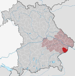
| Location of the district of Griesbach i.Rottal in Bavaria | ||
  |
||

The district of Griesbach im Rottal , officially the district of Griesbach i.Rottal , belonged to the Bavarian administrative district of Niederbayern . Its former area is now largely in the Passau district .
geography
Important places
The largest places were Griesbach , Rotthalmünster , Birnbach and Ruhstorf . The district office was located in Griesbach Castle .
Neighboring areas
In 1972 the district bordered in a clockwise direction to the west on the districts of Pfarrkirchen , Vilshofen and Passau . In the east and south it bordered Upper Austria , Ried im Innkreis district .
history
district Court
In 1803, in the course of the administrative restructuring of Bavaria, the district court of Griesbach im Rottal was established. After the establishment of the Kingdom of Bavaria, this was added to the Lower Danube District, whose capital was Passau.
In 1838 the Lower Danube District was renamed the District of Lower Bavaria , from which the administrative district of the same name emerged . The district capital was moved to Landshut. In the course of this administrative reform, the district court of Griesbach im Rottal had to cede several municipalities to the newly established district court of Rotthalmünster.
District Office
The district office of Griesbach was formed in 1862 through the merger of the regional courts of the older order Griesbach im Rottal and Rotthalmünster.
On January 1, 1914, the district office of Griesbach im Rottal transferred the community of Asenham to the district office of Pfarrkirchen.
district
On January 1, 1939, the designation district was introduced as everywhere else in the German Reich . The district office became the district of Griesbach im Rottal.
On July 1, 1972, the district of Griesbach im Rottal was dissolved as part of the regional reform in Bavaria . The communities of Bayerbach , Birnbach (today Bad Birnbach ) and Kindlbach were added to the Rottal-Inn district. All other communities came to the district of Passau together with the district Wegscheid , many communities from the district Vilshofen and the community Pörndorf from the district Eggenfelden .
Population development
| year | Residents | source |
|---|---|---|
| 1864 | 30.195 | |
| 1885 | 33,447 | |
| 1900 | 33.143 | |
| 1910 | 35,148 | |
| 1925 | 34,519 | |
| 1939 | 32,252 | |
| 1950 | 48,597 | |
| 1960 | 40,600 | |
| 1971 | 42,900 |
Communities
Before the start of the Bavarian regional reform, the Griesbach district comprised 36 communities in the 1960s:
|
|
The municipality of Buchet was incorporated into Weng in 1934.
License Plate
On July 1, 1956, the district was assigned the GRI distinguishing mark when the vehicle license plates that are still valid today were introduced . It was issued until April 28, 1973. In connection with the license plate liberalization , it has been available in the Rottal-Inn district since July 10, 2013, but not in the Passau district.
literature
- Günther U. Müller: Our district of Griesbach i. Rottal. Publishing house Bild + Druck, Munich 1969.
Individual evidence
- ^ Wilhelm Volkert (ed.): Handbook of Bavarian offices, communities and courts 1799–1980 . CH Beck, Munich 1983, ISBN 3-406-09669-7 , p. 474 .
- ^ Wilhelm Volkert (ed.): Handbook of Bavarian offices, communities and courts 1799–1980 . CH Beck, Munich 1983, ISBN 3-406-09669-7 , p. 97 .
- ^ Federal Statistical Office (ed.): Historical municipality directory for the Federal Republic of Germany. Name, border and key number changes in municipalities, counties and administrative districts from May 27, 1970 to December 31, 1982 . W. Kohlhammer, Stuttgart / Mainz 1983, ISBN 3-17-003263-1 , p. 609 .
- ^ Ordinance on the reorganization of Bavaria into rural districts and independent cities of December 27, 1971
- ^ Eugen Hartmann: Statistics of the Kingdom of Bavaria . Ed .: Royal Bavarian Statistical Bureau. Munich 1866, population figures of the district offices 1864 ( digitized version ).
- ↑ Royal Bavarian Statistical Bureau (ed.): Localities directory of the Kingdom of Bavaria . Munich 1888, population figures of the district offices 1885 ( digitized ).
- ↑ a b www.gemeindeververzeichnis.de
- ^ Localities directory for the Free State of Bavaria, based on the census of June 16, 1925
- ↑ Statistical Yearbook for the German Reich 1940
- ↑ Statistical Yearbook for the Federal Republic of Germany 1952
- ↑ Statistical Yearbook for the Federal Republic of Germany 1961
- ↑ Statistical Yearbook for the Federal Republic of Germany 1973
- ^ Official register of places for Bavaria 1964
Aichach | Alzenau i.UFr. | Amberg | Bad Aibling | Bad Neustadt adSaale | Bad Toelz | Beilngries | Berchtesgaden | Bow | Brückenau | Burglengenfeld | Dingolfing | Dinkelsbühl | Donauwörth | Ebermannstadt | Boars | Eggenfelden | Erlangen | Eschenbach idOPf. | Feuchtwangen | Friedberg | Feet | Gemünden a.Main | Gerolzhofen | Grafenau | Griesbach i.Rottal | Gunzenhausen | Hammelburg | Hassfurt | Hersbruck | Hilpoltstein | Höchstadt adAisch | Hofheim i.UFr. | Illertissen | Ingolstadt | Karlstadt | Kaufbeuren | Kemnath | Kempten (Allgäu) | Königshofen i.Grabfeld | Kötzting | Krumbach (Swabia) | Landau adIsar | Lauf adPegnitz | Running | Lohr a.Main | Mainburg | Mallersdorf | Marktheidenfeld | Marktoberdorf | Mellrichstadt | Memmingen | Mindelheim | Münchberg | Nabburg | Naila | Neuburg adDonau | Neunburg vorm Wald | Neustadt adAisch | Nordlingen | Nuremberg | Obernburg am Main | Oberviechtach | Ochsenfurt | Parsberg | Pegnitz | Parish churches | Rehau | Riedenburg | Roding | Rothenburg ob der Tauber | Rottenburg adLaaber | Scheinfeld | Schongau | Schrobenhausen | Schwabach | Schwabmünchen | Sonthofen | Stadtsteinach | Staffelstein | Straubing | Sulzbach-Rosenberg | Uffenheim | Viechtach | Vilsbiburg | Vilshofen | Vohenstrauss | Waldmünchen | Wasserburg a.Inn | Wegscheid | Weilheim i.OB | Weißenburg i.Bay. | Wertingen | Wolfratshausen | Wolfstein
1939–1945 affiliated districts: Bergreichenstein | Eisenstein market | Prachatitz