
Viechtach district
| coat of arms | Germany map | |
|---|---|---|

|
Coordinates: 49 ° 5 ' N , 12 ° 53' E |
|
| Basic data (as of 1972) | ||
| State : | Bavaria | |
| Administrative region : | Lower Bavaria | |
| Administrative headquarters : | Viechtach | |
| Area : | 412.68 km 2 | |
| Residents: | 30,096 (May 27, 1970) | |
| Population density : | 73 inhabitants per km 2 | |
| License plate : | VIT | |
| Circle key : | 09 2 48 | |
| Circle structure: | 23 municipalities | |
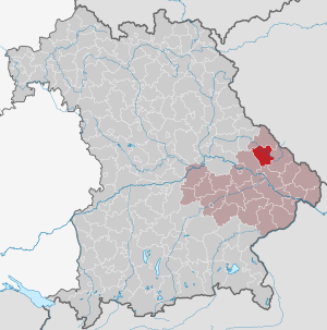
| Location of the district of Viechtach in Bavaria | ||
  |
||

The district of Viechtach belonged to the Bavarian administrative district of Lower Bavaria . His former area is now in the Regen district .
geography
Important places
The largest places were Viechtach , Teisnach , Prackenbach and Ruhmannsfelden .
Neighboring areas
In 1972 the district bordered in a clockwise direction to the north on the districts of Kötzting , Regen , Deggendorf and Bogen .
history
district Court
In 1803 the district court Viechtach was established in the course of the administrative restructuring of Bavaria . After the founding of the Kingdom of Bavaria, this was added to the Regenkreis , whose capital was Straubing until 1810.
In 1810 the district court Viechtach came to the Unterdonaukreis with the capital Passau.
In 1838 the Lower Danube District was renamed the District of Lower Bavaria , from which the administrative district of the same name emerged .
District Office
The district office Viechtach followed the same-area district court of the older order Viechtach in 1862.
district
On January 1, 1939, the designation district was introduced as everywhere else in the German Reich . The district office became the Viechtach district.
On July 1, 1972, the district of Viechtach became part of the district of Regen as part of the regional reform in Bavaria .
Population development
| year | Residents | source |
|---|---|---|
| 1864 | 18,835 | |
| 1885 | 20,828 | |
| 1900 | 22.092 | |
| 1910 | 23,471 | |
| 1925 | 25,318 | |
| 1939 | 26,803 | |
| 1950 | 34,139 | |
| 1960 | 29,700 | |
| 1971 | 30,700 |
Communities
Before the beginning of the Bavarian regional reform, the district of Viechtach comprised 23 communities in the 1960s:
|
|
The municipality of Sackenried was incorporated into Wettzell on January 1, 1946 and is now part of Bad Kötzting in the Cham district.
License Plate
On July 1, 1956, the district was assigned the distinguishing mark VIT when the vehicle registration number that is still valid today was introduced . It was issued until August 3, 1974. It has been available again in the Regen district since March 1, 2018 .
Individual evidence
- ^ Wilhelm Volkert (ed.): Handbook of Bavarian offices, communities and courts 1799–1980 . CH Beck, Munich 1983, ISBN 3-406-09669-7 , p. 584 .
- ^ Wilhelm Volkert (ed.): Handbook of Bavarian offices, communities and courts 1799–1980 . CH Beck, Munich 1983, ISBN 3-406-09669-7 , p. 97 .
- ^ Federal Statistical Office (ed.): Historical municipality directory for the Federal Republic of Germany. Name, border and key number changes in municipalities, counties and administrative districts from May 27, 1970 to December 31, 1982 . W. Kohlhammer, Stuttgart / Mainz 1983, ISBN 3-17-003263-1 , p. 624 .
- ^ Eugen Hartmann: Statistics of the Kingdom of Bavaria . Ed .: Royal Bavarian Statistical Bureau. Munich 1866, population figures of the district offices 1864 ( digitized version ).
- ↑ Royal Bavarian Statistical Bureau (ed.): Localities directory of the Kingdom of Bavaria . Munich 1888, population figures of the district offices 1885 ( digitized ).
- ↑ a b www.gemeindeververzeichnis.de
- ^ Localities directory for the Free State of Bavaria, based on the census of June 16, 1925
- ↑ Statistical Yearbook for the German Reich 1940
- ↑ Statistical Yearbook for the Federal Republic of Germany 1952
- ↑ Statistical Yearbook for the Federal Republic of Germany 1961
- ↑ Statistical Yearbook for the Federal Republic of Germany 1973
- ^ Official register of places for Bavaria 1964
Aichach | Alzenau i.UFr. | Amberg | Bad Aibling | Bad Neustadt adSaale | Bad Toelz | Beilngries | Berchtesgaden | Bow | Brückenau | Burglengenfeld | Dingolfing | Dinkelsbühl | Donauwörth | Ebermannstadt | Boars | Eggenfelden | Erlangen | Eschenbach idOPf. | Feuchtwangen | Friedberg | Feet | Gemünden a.Main | Gerolzhofen | Grafenau | Griesbach i.Rottal | Gunzenhausen | Hammelburg | Hassfurt | Hersbruck | Hilpoltstein | Höchstadt adAisch | Hofheim i.UFr. | Illertissen | Ingolstadt | Karlstadt | Kaufbeuren | Kemnath | Kempten (Allgäu) | Königshofen i.Grabfeld | Kötzting | Krumbach (Swabia) | Landau adIsar | Lauf adPegnitz | Running | Lohr a.Main | Mainburg | Mallersdorf | Marktheidenfeld | Marktoberdorf | Mellrichstadt | Memmingen | Mindelheim | Münchberg | Nabburg | Naila | Neuburg adDonau | Neunburg vorm Wald | Neustadt adAisch | Nordlingen | Nuremberg | Obernburg am Main | Oberviechtach | Ochsenfurt | Parsberg | Pegnitz | Parish churches | Rehau | Riedenburg | Roding | Rothenburg ob der Tauber | Rottenburg adLaaber | Scheinfeld | Schongau | Schrobenhausen | Schwabach | Schwabmünchen | Sonthofen | Stadtsteinach | Staffelstein | Straubing | Sulzbach-Rosenberg | Uffenheim | Viechtach | Vilsbiburg | Vilshofen | Vohenstrauss | Waldmünchen | Wasserburg a.Inn | Wegscheid | Weilheim i.OB | Weißenburg i.Bay. | Wertingen | Wolfratshausen | Wolfstein
1939–1945 affiliated districts: Bergreichenstein | Eisenstein market | Prachatitz