
Boebrach
| coat of arms | Germany map | |
|---|---|---|

|
Coordinates: 49 ° 3 ' N , 13 ° 2' E |
|
| Basic data | ||
| State : | Bavaria | |
| Administrative region : | Lower Bavaria | |
| County : | rain | |
| Height : | 576 m above sea level NHN | |
| Area : | 27.56 km 2 | |
| Residents: | 1629 (Dec. 31, 2019) | |
| Population density : | 59 inhabitants per km 2 | |
| Postal code : | 94255 | |
| Area code : | 09923 | |
| License plate : | REG, VIT | |
| Community key : | 09 2 76 118 | |
| Community structure: | 29 districts | |
| Address of the municipal administration: |
Rathausplatz 1 94255 Böbrach |
|
| Website : | ||
| Mayor : | Gerd Schönberger ( CSU ) | |
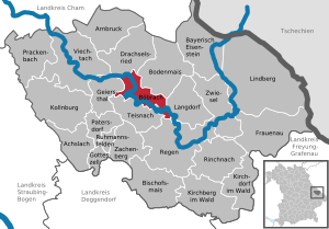
| Location of the municipality of Böbrach in the Regen district | ||
  |
||


Böbrach is a municipality in the Lower Bavarian district of Regen .
geography
Geographical location
Böbrach is located in the Danube Forest region in the middle of the Bavarian Forest about 17 km east of Viechtach , 14 km northwest of the district town of Regen and only six kilometers from Bodenmais , where the nearest Waldbahn station is also located.
Community structure
There are 29 officially named municipal parts:
There is only the district Böbrach.
history
Until the church is planted
Böbrach belonged to the Straubing Rent Office and the Viechtach Regional Court in the Electorate of Bavaria . The judicial responsibilities were divided between the Viechtach Regional Court and the Linden Regional Court. In the course of the administrative reforms in Bavaria , today's municipality was created with the municipal edict of 1818 .
Population development
Between 1988 and 2018, the community grew from 1,611 to 1,648 by 37 inhabitants or 2.3%.
- 1970: 1400 inhabitants
- 1987: 1518 inhabitants
- 1991: 1673 inhabitants
- 1995: 1656 inhabitants
- 2000: 1668 inhabitants
- 2005: 1637 inhabitants
- 2010: 1627 inhabitants
- 2015: 1646 inhabitants
politics
Municipal council
The municipal council consists of the first mayor and the members. Based on the results of the municipal council election on March 15, 2020 , the 12 municipal council members have been made up of the following four groups since May 1, 2020:
- CSU : 5 seats (40.05% of the vote)
- Citizen list Böbrach : 2 seats (19.86% of the vote)
- FW : 3 seats (25.43% of the vote)
- Green / New Paths: 2 seats (14.66% of the vote)
mayor
Gerd Schönberger (CSU) has been the first mayor since May 1, 2020. In 2020 he was elected with 57.67% of the vote. The second mayor is Erich Süß (CSU), the third mayor is Gabriele Weikl (FW).
coat of arms
Description : In blue over a lowered silver wave bar a jumping silver beaver; in the left upper corner a golden apple.
Architectural monuments
statistics
In 1998, according to official statistics, there were no employees at the place of work in the manufacturing industry 41 and in the trade and transport sector. In other economic areas, 50 people were employed at the place of work subject to social security contributions. There were a total of 549 employees at the place of residence subject to social security contributions. There were seven companies in the manufacturing sector and two in the construction sector. In addition, in 1999 there were 51 farms with an agriculturally used area of 590 ha, of which 49 ha were arable land and 541 ha were permanent green space.
traffic
Thanks to the Gotteszell – Viechtach line of the Regentalbahn , which was opened in 1890 , the place could be reached by passenger trains via the Böbrach stop on the left side of the Black Rain until 1991 . The place was connected by a ferry until the 1980s. After the shutdown of passenger traffic, the route was only used by excursion trains on weekends. On September 13, 2016, daily passenger traffic was resumed, initially for two years. However, the trains do not stop in Böbrach, since the Teisnach train station, three kilometers west of the town, has been faster to reach since the ferry was shut down .
About five kilometers east of Böbrach is the Bodenmais stop on the Bodenmais – Zwiesel line .
Böbrach is on the state road 2136 from Patersdorf via Teisnach to Bodenmais and about seven kilometers northeast of the federal highways B 85 and B 11 .
education
The following institutions exist (as of: 1999):
- a kindergarten with 50 kindergarten places and 59 children
- an elementary school with four teachers and 71 students
Web links
Individual evidence
- ↑ "Data 2" sheet, Statistical Report A1200C 202041 Population of the municipalities, districts and administrative districts 1st quarter 2020 (population based on the 2011 census) ( help ).
- ↑ a b c wahl.info - candidates & results
- ^ Municipality of Böbrach in the local database of the Bavarian State Library Online . Bayerische Staatsbibliothek, accessed on January 5, 2018.
- ↑ Entry on the Böbrach coat of arms in the database of the House of Bavarian History
Bamming | Bärnerau | Böbrach | Böbrachmühle | Dirnberg | Corner | Etzendorf | Gstaudach | Haidsberg | Hammermühl | Höhmannsbühl | Hunter's House | Katzenbach | Crown hammer | Maisried | Meindlgrub | Oberauerkiel | Obersteinhaus | Wasteland | Pfefferhaus | Raschau | Rettenberg | Roppendorf | Schmalzgrub | Schrollhof | Stone | Lower keel | Weghof | Wieshof

Achslach | Arnbruck | Bayerisch Eisenstein | Bishop corn | Böbrach | Ground corn | Drachselsried | Frauenau | Geiersthal | Gotteszell | Kirchberg in the forest | Kirchdorf im Wald | Kollnburg | Langdorf | Lindberg | Patersdorf | Prackenbach | Rain | Rinchnach | Ruhmannsfelden | Teisnach | Viechtach | Zachenberg | Zwiesel