
Langdorf
| coat of arms | Germany map | |
|---|---|---|

|
Coordinates: 49 ° 1 ' N , 13 ° 9' E |
|
| Basic data | ||
| State : | Bavaria | |
| Administrative region : | Lower Bavaria | |
| County : | rain | |
| Height : | 645 m above sea level NHN | |
| Area : | 34.37 km 2 | |
| Residents: | 1800 (Dec. 31, 2019) | |
| Population density : | 52 inhabitants per km 2 | |
| Postal code : | 94264 | |
| Primaries : | 09921, 09922 | |
| License plate : | REG, VIT | |
| Community key : | 09 2 76 129 | |
| Community structure: | 15 districts | |
| Address of the municipal administration: |
Main street 8 94264 Langdorf |
|
| Website : | ||
| Mayor : | Michael Englram ( CSU ) | |
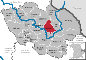
| Location of the municipality of Langdorf in the Regen district | ||
  |
||


Langdorf is a municipality in the Lower Bavarian district of Regen and a state-approved resort .
geography
Geographical location
The street village of Langdorf is located both in the Arber region and in the Zwieseler Winkel in the middle of the Bavarian Forest at the intersection of the streets between Bodenmais (seven kilometers), Zwiesel (seven kilometers) and Regen (six kilometers). The highest point in Langdorf is the 984 m high Kronberg . The community also has a railway station on the Zwiesel – Bodenmais railway line , which is used every hour by trains from the forest railway on the Zwiesel – Bodenmais route.
Community structure
Langdorf has 15 districts:
|
There are the districts of Langdorf, Brandten and Schöneck.
history
Until the church is planted
The place originated around the year 1300. In 1324 it was pledged with the villages of Schöneck, Klaffermühle and Schwarzach by the Wittelsbachers to the Lords of Degenberg . They resided at Weissenstein Castle and were represented in Langdorf by a bailiff. On August 5, 1468, Duke Albrecht IV demanded the four places back after previous tensions with the Degenbergs. The refusal of the Degenberger formed the occasion for the outbreak of the Böckler war . After the castle was destroyed, the old conditions were not restored until 1478.
Langdorf belonged to the Straubing Rent Office and the Weißenstein Regional Court of the Electorate of Bavaria. The church was built between 1674 and 1677. In 1806 the parish of Langdorf was created by separating it from the parish of Regen. This year the existing school was raised to a normal school . In the course of the administrative reforms in the Kingdom of Bavaria , today's municipality was created with the municipal edict of 1818 .
20th century
The parish church of St. Maria Magdalena was enlarged in 1922 as part of a renovation.
Incorporations
On January 1, 1976, the previously independent community of Brandten was incorporated.
Population development
Between 1988 and 2018, the population fell from 1,903 to 1,821 by 82 people or 4.3%.
- 1961: 1636 inhabitants
- 1970: 1719 inhabitants
- 1987: 1779 inhabitants
- 1991: 1910 inhabitants
- 1995: 1979 inhabitants
- 2000: 2015 inhabitants
- 2005: 2034 inhabitants
- 2010: 2007 inhabitants
- 2015: 1847 inhabitants
politics
Municipal council
Since the local elections on March 15, 2020, the municipal council has been composed as follows:
- CSU : 5 seats (40.22% of the vote)
- SPD : 3 seats (28.59% of the vote)
- FWL : 3 seats (21.74% of the vote)
- Junge Union : 1 seat (9.45% of the vote)
mayor
Michael Englram (CSU) has been mayor since March 2020. He prevailed in 2020 with 51.12% in the first ballot. His predecessor was Otto Probst (CSU).
coat of arms
Description : Split by silver and blue, in front a sloping five-leaf red linden branch, behind an upright, outward-swept silver clearing ax.
Community partnerships
Langdorf maintains partnerships with the French Saint-Crépin-Ibouvillers and the Austrian Nebelberg .
Buildings
On the 833 m high Oberberg to the west of Langdorf there is a 28 m high observation tower .
Soil monuments
See: List of ground monuments in Langdorf
statistics
In 1998, according to official statistics, there were no employees at the place of work in the manufacturing industry 67 or in the trade and transport sector. In other economic sectors, 43 people were employed at the place of work subject to social security contributions. There were a total of 634 employees at the place of residence subject to social security contributions. There were none in the manufacturing sector and three in the construction sector. In addition, in 1999 there were 63 farms with an agriculturally used area of 705 ha, of which 19 ha were arable land and 686 ha were permanent green space.
education
The following institutions exist (as of: 1999):
- Kindergarten with 50 kindergarten places and 56 children
- Elementary school with six teachers and 110 students
Individual evidence
- ↑ "Data 2" sheet, Statistical Report A1200C 202041 Population of the municipalities, districts and administrative districts 1st quarter 2020 (population based on the 2011 census) ( help ).
- ↑ a b Mayor / Lord Mayor in municipalities belonging to the district (as of May 1st, 2020). (xlsx) Bavarian State Office for Statistics, accessed on May 31, 2020 .
- ^ Community Langdorf in the local database of the Bavarian State Library Online . Bayerische Staatsbibliothek, accessed on January 14, 2018.
- ^ Federal Statistical Office (ed.): Historical municipality directory for the Federal Republic of Germany. Name, border and key number changes in municipalities, counties and administrative districts from May 27, 1970 to December 31, 1982 . W. Kohlhammer GmbH, Stuttgart / Mainz 1983, ISBN 3-17-003263-1 , p. 622 .
- ↑ Map services of the Federal Agency for Nature Conservation ( information )
- ↑ Lookout tower in Langdorf on bayerischer-wald.de
Web links
- Entry on the coat of arms of Langdorf in the database of the House of Bavarian History

Achslach | Arnbruck | Bayerisch Eisenstein | Bishop corn | Böbrach | Ground corn | Drachselsried | Frauenau | Geiersthal | Gotteszell | Kirchberg in the forest | Kirchdorf im Wald | Kollnburg | Langdorf | Lindberg | Patersdorf | Prackenbach | Rain | Rinchnach | Ruhmannsfelden | Teisnach | Viechtach | Zachenberg | Zwiesel