
Ruhmannsfelden
| coat of arms | Germany map | |
|---|---|---|

|
Coordinates: 48 ° 59 ' N , 12 ° 59' E |
|
| Basic data | ||
| State : | Bavaria | |
| Administrative region : | Lower Bavaria | |
| County : | rain | |
| Management Community : | Ruhmannsfelden | |
| Height : | 536 m above sea level NHN | |
| Area : | 5.81 km 2 | |
| Residents: | 2047 (Dec. 31, 2019) | |
| Population density : | 353 inhabitants per km 2 | |
| Postal code : | 94239 | |
| Area code : | 09929 | |
| License plate : | REG, VIT | |
| Community key : | 09 2 76 142 | |
| Market structure: | 14 districts | |
Market administration address : |
Am Rathaus 1 94239 Ruhmannsfelden |
|
| Website : | ||
| Mayor : | Werner Troiber ( CSU ) | |
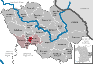
| Location of the Ruhmannsfelden market in the Regen district | ||
  |
||


Ruhmannsfelden is a market in the Lower Bavarian district of Regen and the seat of the Ruhmannsfelden administrative association .
geography
Geographical location
The state-approved resort of Ruhmannsfelden is located in the Danube Forest region in the Bavarian Forest Nature Park , more precisely in the Teisnachtal . The old market town is about 18 km north of Deggendorf , 15 km southeast of Viechtach and 13 km west of the district town of Regen .
Community structure
Ruhmannsfelden has 14 districts:
|
There is only the district Ruhmannsfelden.
history
Until the church is planted
Around 1100 there was a permanent castle here , which was inhabited by the servants of the Counts of Bogen . Arnold von Ruhmannsfelden fought in a tournament in Zurich in 1165 , and Gebo von Ruhmannsfelden appeared as a witness between 1184 and 1194 in a tradition from Oberalteich Abbey .
Around the middle of the 12th century a settlement was established around the castle. After the nobles von Ruhmannsfelden died out, the Pfellinger family took over the castle after 1250. After the death of the last Pfellinger, his possessions fell to the sovereign. Duke Heinrich XIII. allowed the demolition of the castle on the condition that the stones should be used after Gotteszell to expand the local monastery.
The manor with the place Ruhmannsfelden was in 1295 by the Bavarian dukes Otto III. , Ludwig III. and Stephan I. sold to the Aldersbach monastery . Around 1400, when Jakob von Degenberg was appointed Vogt over the place, it had already been raised to the market .
In 1496 the Aldersbach monastery sold the Ruhmannsfelden market to the Degenbergers, subject to redemption. This happened a few years later, and in 1503 the place was exchanged for the Gotteszell monastery . Only the church in Ruhmannsfelden, which was a branch of the Geiersthal parish until 1652 , remained in the possession of Aldersbach Monastery.
There were disputes with Gotteszell Monastery, which was much closer than Aldersbach, because Ruhmannsfelden wanted to enforce its market rights. In 1522 the market went up in flames.
The place was part of the Electorate of Bavaria , but belonged to the closed Hofmark Gotteszell . In 1658 Ruhmannsfelden also came to the Gotteszell Monastery in church terms. After the Thirty Years' War there was a dispute with Viechtach about the debts incurred during wartime. In 1673 the government restored peace and expressly forbade the Viechtachers from contemptuously calling the Ruhmannsfeldeners "Hofmärkler".
Until the secularization of 1803 Ruhmannsfelden belonged to the Gotteszell Monastery with land, lower jurisdiction and pastoral care. Ruhmannsfelden had a market court, which, however, could only enforce a small part of its rights. Around 1723 it became a parish with the right of occupation by the Gotteszell Monastery. From 1806, many places from the Geiersthal parish were re-parish to Ruhmannsfelden. After the dissolution of the Hofmark, the current municipality was created in the course of administrative reforms in the Kingdom of Bavaria with the municipal edict of 1818 .
19th to 21st century
In the years 1820, 1889 and 1894 fires raged in Ruhmannsfelden and largely destroyed the old building fabric. In 1890, with the opening of the Gotteszell – Viechtach railway line , the market was connected to the railway. The more than 300-year tradition of hand-printed woven goods production continues to this day.
Population development
Between 1988 and 2018 the market grew from 1,966 to 2,048 by 82 inhabitants or 4.2%.
- 1961: 2119 inhabitants
- 1970: 2095 inhabitants
- 1987: 1972 inhabitants
- 1991: 2026 inhabitants
- 1995: 2164 inhabitants
- 2000: 2155 inhabitants
- 2005: 2133 inhabitants
- 2010: 2019 inhabitants
- 2015: 2100 inhabitants
politics
Market council
The local elections of March 15, 2020 and earlier resulted in the following allocation of seats:
| CSU |
New list Ruhmannsfelden |
GREEN |
Ruhmannsfeldener voter community |
total | |
| 2020 | 8th | 6th | - | - | 14th |
| 2014 | 8th | 5 | 1 | - | 14th |
| 2008 | 6th | 6th | - | 2 | 14th |
mayor
The mayor is Werner Troiber (CSU), who replaced his predecessor Josef Brunner (CSU) in the 2014 local elections. After 30 years in office, he did not stand for election.
Troiber was re-elected on March 15, 2020 with 88.1% unopposed candidate.
Culture and sights
In the southeast of Ruhmannsfelden there is the Osterbrünnl Chapel , a pilgrimage chapel.
The classical parish church of Sankt Laurentius was built after the market fire of 1820, which only the late medieval tower survived, from 1826 to 1828 according to plans by Erasmus Hofstetter from Passau.
West of Ruhmannsfelden near the B 11 is the Protestant Gnadenkirche, which was built in 1957/58 according to plans by the architect Eberhard Ritz from Viechtach .
Economy and Infrastructure
Economy including agriculture and forestry
In 1998, according to official statistics, there were no employees at the place of work in the manufacturing industry or in trade and transport who were subject to social insurance contributions. In other economic sectors, 133 people were employed at the place of work subject to social security contributions. There were a total of 722 employees at the place of residence subject to social insurance contributions. There were three companies in the manufacturing sector and three in the construction sector. In addition, in 1999 there were 29 farms with an agricultural area of 213 hectares, of which 171 hectares were permanent green space.
traffic
Ruhmannsfelden is located directly on the federal road 11 (Europastraße 53) from Deggendorf to Bayerisch Eisenstein .
The closest train station of the Bavarian Forest Railway with hourly connections to Plattling and Bayerisch Eisenstein is in Gotteszell, three kilometers away . The Ruhmannsfelden train station is on the Regentalbahn AG route to Viechtach . The two-year trial operation was extended by a further three years until 2021 and should continue to demonstrate the need to reactivate this railway line.
education
There are the following institutions (as of 2018):
- Day care center with 92 kindergarten places and 87 children, including nine children under three years of age
- Elementary and secondary school with 18 classes, 28 teachers and 360 students
Personalities
- August Högn (1878–1961), school principal, local researcher and composer
- Joseph Lukas (1834–1878), pastor, member of the Bavarian state parliament and in the customs parliament
- Franz Seraph Reicheneder (1905–1976), pastor and local history researcher
Individual evidence
- ↑ "Data 2" sheet, Statistical Report A1200C 202041 Population of the municipalities, districts and administrative districts 1st quarter 2020 (population based on the 2011 census) ( help ).
- ↑ Markt Ruhmannsfelden in the local database of the Bayerische Landesbibliothek Online . Bayerische Staatsbibliothek, accessed on August 20, 2018.
- ↑ a b Municipal council election & mayoral election in Ruhmannsfelden 2020 - candidates & results. In: Wahl.info. March 15, 2020, accessed May 4, 2020 .
- ↑ Renate Roßberger: Rail test operation Viechtach-Gotteszell is extended. br.de, May 24, 2018, accessed on September 5, 2019 .
Web links
- Entry on the coat of arms of Ruhmannsfelden in the database of the House of Bavarian History
Bergerhäusl | Bergerweid | Bruckmühle | Hahnburg | Elevated road | Huberweid | Leuthenmühle | Multernhäusl | Powder mill | Rabenstein | Ruhmannsfelden | Stegmühle | Stone widths | Stick wood

Achslach | Arnbruck | Bayerisch Eisenstein | Bishop corn | Böbrach | Ground corn | Drachselsried | Frauenau | Geiersthal | Gotteszell | Kirchberg in the forest | Kirchdorf im Wald | Kollnburg | Langdorf | Lindberg | Patersdorf | Prackenbach | Rain | Rinchnach | Ruhmannsfelden | Teisnach | Viechtach | Zachenberg | Zwiesel