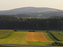
Church village in the forest
| coat of arms | Germany map | |
|---|---|---|

|
Coordinates: 48 ° 55 ' N , 13 ° 16' E |
|
| Basic data | ||
| State : | Bavaria | |
| Administrative region : | Lower Bavaria | |
| County : | rain | |
| Height : | 685 m above sea level NHN | |
| Area : | 30.57 km 2 | |
| Residents: | 2100 (Dec. 31, 2019) | |
| Population density : | 69 inhabitants per km 2 | |
| Postal code : | 94261 | |
| Area code : | 09928 | |
| License plate : | REG, VIT | |
| Community key : | 09 2 76 127 | |
| Community structure: | 13 districts | |
| Address of the municipal administration: |
Marienbergstrasse 3 94261 Kirchdorf i.Wald |
|
| Website : | ||
| Mayor : | Alois Wildfeuer jun. ( FW ) | |
| Location of the municipality of Kirchdorf i.Wald in the Regen district | ||
Kirchdorf im Wald (officially: Kirchdorf i.Wald ) is a municipality in the Lower Bavarian district of Regen .
geography
Geographical location
Kirchdorf im Wald is located in the Danube Forest region in the middle of the Bavarian Forest, directly on the federal highway 85 at the foot of the 1,000 meter high Eschenberg . The village is located about 13 km southeast of the district town of Regen , 16 km south of Zwiesel, 30 km northeast of Deggendorf , 17 km west of Grafenau and 26 km from the A 3 , exit Hengersberg . The nearest railway station of the Bavarian Forest Railway with regular connections is 9 km away in Spiegelau , where the Bavarian Forest National Park begins. Kirchdorf, on the other hand, is located in the Bavarian Forest Nature Park .
Community structure
Kirchdorf i.Wald has 13 districts:
history
Until the church is planted
Around the year 1040 the monk Wilhelm lived here as a hermit. Kirchdorf was founded in 1144 under the names Maria-Berg and Maria im Wald as a subsidiary of Kirchberg . Kirchdorf has been Kirchort for the surrounding area since 1149, initially as a subsidiary of Kirchberg, which was incorporated into the Rinchnach provost in 1204 .
In the description of taxes / goods by Abbot Hermann in 1254, the place comprising 14 fiefs was first referred to as Chirchdorf . Until 1289 it was part of the church of the Rinchnach provost, and from 1289 to 1570 it was again a branch of Kirchberg. Own parish in 1570, it was reassigned to Rinchnach in 1576. In 1649 Kirchdorf had 70 deaths from the plague. The church was rebuilt in 1755. In 1806 Kirchdorf was finally established its own parish in the course of secularization and in 1808 the parsonage was built from scratch. In 1818 the political municipality was established.
name suffix
To distinguish it from other places of the same name, Kirchdorf received the addition in the forest in 1955 . At that time the village had 53 houses with 335 inhabitants.
Incorporations
On January 1, 1972, the previously independent communities Abtschlag and Schlag were incorporated.
Population development
Between 1988 and 2018 the community grew from 2,032 to 2,121 by 89 inhabitants or 4.4%.
politics
Municipal council
The council of the community consists of 14 councilors:
- CSU : 5 seats with 38.2% of the vote
- FW : 5 seats with 36.0% of the vote
- SPD 4 seats with 25.8% of the vote
(Status: local elections of March 16, 2014 )
mayor
Alois Wildfeuer (FWG) was elected mayor on March 2, 2008 with 71.17% of the vote. When he was re-elected in 2014, he received 91.5% of the vote.
coat of arms
Description : In gold on a green three-mountain, covered with a silver heraldic lily, a green fir tree, in front of an upright red abbot's staff, in the back by an upright red reed hoe .
Architectural monuments
- Parish Church Maria Immaculate Conception , a baroque church with a high altar by Benjamin Schreiter .
Soil monuments
See: List of ground monuments in Kirchdorf im Wald
traffic
The community is located directly on federal highway 85 .
Individual evidence
- ↑ "Data 2" sheet, Statistical Report A1200C 202041 Population of the municipalities, districts and administrative districts 1st quarter 2020 (population based on the 2011 census) ( help ).
- ↑ Bavarian State Library Online (BLO)
- ^ Wilhelm Volkert (ed.): Handbook of Bavarian offices, communities and courts 1799–1980 . CH Beck, Munich 1983, ISBN 3-406-09669-7 , p. 553 .
- ↑ a b wahl.info - candidates & results
Web links
- Entry on the coat of arms of Kirchdorf im Wald in the database of the House of Bavarian History


