Discount
|
Discount
Municipality Kirchdorf im Wald
Coordinates: 48 ° 53 ′ 8 ″ N , 13 ° 15 ′ 27 ″ E
|
|
|---|---|
| Height : | 620 m |
| Area : | 7.43 km² |
| Residents : | 275 (May 25 1987) |
| Population density : | 37 inhabitants / km² |
| Incorporation : | January 1, 1972 |
| Postal code : | 94261 |
| Area code : | 09928 |
|
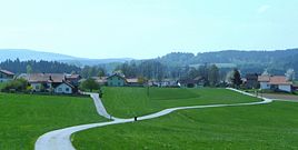
View of Abtschlag from the north-east
|
|
Abtschlag is a former municipality about two kilometers south of Kirchdorf in the Regen district in Lower Bavaria , which was incorporated into Kirchdorf im Wald in 1972 . In addition to the actual district ( village ) Abtschlag (173 inhabitants at the 1987 census), the village of Grünbach (102 inhabitants) and the wasteland of Zellermühle (1925 still with 13 inhabitants in two buildings, 1987 already uninhabited) belonged to the municipality. The villages of Abtschlag and Grünbach are Angerdörfer . The area of the former municipality forms one of three districts of the municipality Kirchdorf im Wald.
history
Abtschlag is mentioned for the first time in 1254 in the list of goods of Abbot Hermann von Niederaltaich . The place was a foundation of the monastery at the beginning of the 13th century and was assigned to its provost Rinchnach , but was subject to taxes for the maintenance of the church and parish of Kirchdorf. The grouping of courtyards around the triangular village green , which is still recognizable today, shows the planned layout of the village.
With 22 charities and two mills, Abtschlag was the largest settlement in the manorial area of the Rinchnach provost at the time. In 1649 Abtschlag had 113 deaths from the plague . The name is mentioned again in 1742 when a small group of the Pandur lieutenant Bärenhaut invaded Abtschlag and burned three farms down. In 1752 there were still 17 properties in the village. Until 1803, Abtschlag belonged to the Kirchberg basic judge office in Niederalteich . With the secularization in Bavaria in 1803, the monastery property became the property of the farmers. In 1809 Abtschlag had 157 inhabitants, 74 of them male and 83 female.
In 1840 the number of inhabitants was 180, 90 of them male and 90 female. Of the 18 properties, 16 were farms. Irregular four-sided courtyards dominated , and there was also a three-sided courtyard and a hooked courtyard . In addition to the 16 farms, there was only one farmer with rights as a weaver and 2.5 hectares of property on the outskirts, as well as the community-owned keeper's house on the Anger. This keeper house was the considerable commons the district associated with Abtschlag 113.3 hectare. In total, the demarcation comprised 502.6 hectares.
The ownership size of the individual farms ranged between 36.7 hectares and 19.6 hectares for the ten farms around the Anger and 18.5 to 16.8 hectares for the farms at the south-eastern exit of the village. This indicates that the settlement had been expanded by dividing some of the original farms on the southeastern edge. The historical map leaves the former corridor course to Abtschlag each with a Won perpendicular to recognize Anger. In 1845 the village chapel was built on the Anger von Abtschlag, and in 1860 the village chapel of Grünbach. The field chapel is 700 meters northeast of Abtschlag (early 19th century). These three sacred buildings as well as a total of five houses in the two villages are listed.
Later construction activity was largely limited to filling in existing vacant lots at the south-eastern exit of the town. The municipality of Abtschlag had 293 inhabitants in 1895 and 275 inhabitants at the last census in 1987.
The municipality Abtschlag came to Kirchdorf im Wald on January 1, 1972 as part of the municipal reform . In 2008 the Abtschlag volunteer fire brigade celebrated its 100th anniversary.
societies
- Abtschlag volunteer fire department
- Abtschlag village association
Individual evidence
- ↑ Local registers of the Bavarian State Statistical Office 1928 and the Bavarian State Office for Statistics and Data Processing 1990
- ↑ Monuments in Niederbayern, Oldenbourg: Munich 1983, page 301 ISBN 3-486-52393-7
- ^ Wilhelm Volkert (ed.): Handbook of Bavarian offices, communities and courts 1799–1980 . CH Beck, Munich 1983, ISBN 3-406-09669-7 , p. 553 .
literature
- Manfred Burkhardt: Regen: District Courts Zwiesel and Regen, Care Court Weissenstein (Historical Atlas of Bavaria, Altbayern Series I Issue 34) Munich 1975, pp. 42, 86, 272, 275, 281, 287, 290, 294, 295, 328, 329 , 377. ( digital version of the MDZ)
- Ulrich Pietrusky, Donatus Moosauer: The Bavarian Forest - rediscovered in flight , Morsak Verlag, Grafenau, 1985, ISBN 3-87553-228-7


