
Kirchberg in the forest
| coat of arms | Germany map | |
|---|---|---|

|
Coordinates: 48 ° 54 ' N , 13 ° 11' E |
|
| Basic data | ||
| State : | Bavaria | |
| Administrative region : | Lower Bavaria | |
| County : | rain | |
| Height : | 880 m above sea level NHN | |
| Area : | 48.8 km 2 | |
| Residents: | 4362 (Dec. 31, 2019) | |
| Population density : | 89 inhabitants per km 2 | |
| Postal code : | 94259 | |
| Area code : | 09927 | |
| License plate : | REG, VIT | |
| Community key : | 09 2 76 126 | |
| Community structure: | 29 districts | |
| Address of the municipal administration: |
Rathausplatz 1 94259 Kirchberg i. Forest |
|
| Website : | ||
| Mayor : | Robert Muhr ( SPD ) | |
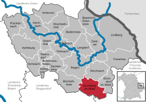
| Location of the municipality of Kirchberg i.Wald in the Regen district | ||
  |
||


Kirchberg im Wald (officially: Kirchberg i.Wald ) is a municipality in the Lower Bavarian district of Regen .
geography
Geographical location
The community is located in the Danube Forest region in the middle of the Bavarian Forest . The highest elevation of the community is the Fürberg near Raindorf at 880 m, the village of Kirchberg is at an altitude of 736 m.
The village of Kirchberg im Wald is located about eleven kilometers south of the district town of Regen , 23 km northeast of Deggendorf , 26 km west of Grafenau and 21 km from the A3 , exit Hengersberg . The closest train station of the Bavarian Forest Railway with regular connections (every hour) is in Regen .
At the Furthmühle, the Kühbach (also called Höllmannsrieder Bach in the upper reaches) and the Hackenbach merge to form the Rinchnacher Ohe , a tributary of the Black Rain .
Community structure

Kirchberg i.Wald has 29 districts:
|
There are also the desert areas of Büchelmann, Dalken, Danzersäge, Fischermühle, Hammermühle and Steinfurthmühle, none of which are official districts.
The municipality of Kirchberg im Wald is divided into the districts of Kirchberg (corresponds to the old municipality of Kirchberg), Raindorf (corresponds to the old municipality of Raindorf) and Reichertsried and Zell (corresponds to the old municipality of Zell).
history
Until the 19th century
Already around the year 1000 there was a castle on the mountain, which a nobleman named Konrad Salikus donated to the Niederaltaich monastery in 1040 with the surrounding goods . In 1066, Emperor Heinrich IV confirmed this donation. In 1144, with the help of a pious man named Wilhelm, a church in honor of St. Godehard built. A parish church in Kirchberg was mentioned for the first time in a document dated July 12, 1146, and monastery property with the Gotthardsberg was transferred to a community of brothers.
Pope Eugene III. confirmed in 1148 the Niederaltaich monastery its ownership of the Gotthardsberg. Around 1200 the name Chirchperch was used instead of Gotthardperch. In 1204 the parish and the Marienberg branch ( Kirchdorf im Wald ) were incorporated into the Rinchnach Provostry. Around 1250 the Niederaltaich monastery had an amthof built in Kirchberg, to which the settlers had to pay their taxes in kind. In 1254 Abbot Hermann von Niederaltaich already counted 13 estates and three mills.
In 1304 the incorporation of the Kirchberg parish was abolished, while Marienberg (Kirchdorf) remained assigned to the Rinchnach monastery. In 1525 it was raised to the Hofmark . In 1622 the Niederaltaich monastery received the brewing license in Kirchberg. During the Thirty Years' War there was an invasion of Sweden in 1634 , later the plague raged in Kirchberg.
In 1703 the Amthof was rebuilt. During the Austrian War of Succession , the place was plundered on January 7, 1743 by a Hungarian free company. On Christmas Day 1744 the church burned down except for the tower. The service was moved to the Amthof's house chapel, built in 1744. In 1745 construction began on the parish church, the interior of which was redesigned in 1747.
After secularization in 1803, the Amthof was sold to Wolfgang Leopold von Kiesling (or Kißling). When the house chapel fell into disrepair, the altar was moved to the vicarage chapel around 1830, which was built after the court yard had been sold. In 1848 the rectory burned down due to arson. In 1855 Kirchberg consisted of 19 houses, of which the Amthof and the rectory were the most important. In 1855/1856 the church was extended to the west. On May 29, 1863, twelve houses and the newly built institute of the English Misses were destroyed in a major fire.
Religions
- Catholic parish Kirchberg i. Forest - Diocese of Passau
Incorporations
On January 1, 1976, the previously independent municipality of Zell with approx. 900 inhabitants was incorporated in the course of the municipal reform. On May 1, 1978 Raindorf was added with about 1150 inhabitants.
Population development
Between 1988 and 2018 the municipality grew from 4,020 to 4,338 by 318 inhabitants or 7.9%.
politics
Municipal council
The municipal council has 16 members:
- CSU : 6 seats with 39.09% of the vote
- SPD : 5 seats with 28.06% of the vote
- Free list : 2 seats with 14.58% of the vote
- Junge Union: 2 seats with 9.77% of the vote
- Kirchberg and the surrounding area : 1 seat with 8.56% of the vote
(Status: local elections on March 15, 2020 )
mayor
The professional first mayor is Robert Muhr from the SPD. He has been in office since May 1, 2020. In the mayoral election in 2020 , he received 56.4 percent of the vote in the first ballot. He was the candidate of the joint election proposal SPD / Free Voting Community.
Referendums
On August 17, 2003 and March 28, 2004, a referendum took place on the question of whether a new school should be built on the outskirts or the old school in the village should be renovated. In both referendums, a slim majority of voters decided in favor of the renovation and against the new building. Nonetheless, on June 30, 2005, after the one-year binding period for referendums had expired, the local council decided to build the new school with 9: 8 votes. The new building was completed in 2007.
coat of arms
Description : In gold over a green three-mountain, a sloping, mutilated red branch and the red bend of an abbot's staff, placed diagonally to the left.
Local partnerships
A partnership with the Italian municipality of Bagnolo di Po has existed since 1994 . The reason for the decision was the common local patron , Saint Gotthard .
Culture and sights

Buildings
- The St. Gotthard Church: built as a castle in 1008, changed to a church with Gothic vaults by Abbot Konrad I in 1144, burned down in 1744 and then rebuilt, expanded to today's size in 1856. The frescoes by K. A. Perlinger from 1790 were uncovered by the Munich painter Josef Wittmann - painter of the neo-baroque - in 1931 and eight new frescos were painted: Fall of Man, Solomon and the Queen of Sheba, expulsion from paradise, Cain's sacrifice, brazen serpent, Moses receives the tablet of the law , Albertus Magnus and Petrus Canisius. A comprehensive renovation took place in 2006.

- Amthof: built in 1250 by order of the Niederaltaich monastery, demolished and rebuilt between 1170 and 1739, the parts still standing today still dominate the appearance of the village center, today it is used as a guesthouse and inn
- Craftsman column: placed on Amthofplatz in 2008 to commemorate the crafts that have died out in the village
- Hangenleither Taferl: The Chapel of Our Lady of Sorrows was built in 1822. The builder of this chapel was Andreas Kapfenberger, who was born in Hangenleithen and is remembered by a stone tablet in the chapel. The chapel was built on a place where a Marterl or a Taferl (a plaque with a picture and an inscription to commemorate or a picture of a saint) once stood. This is why the chapel is still called the Taferlkapelle or Hangenleither Taferl today. Not far from this chapel, the path laid out by Gunther in 1009, from Niederalteich to Bohemia, also passed.
- St. Gotthard Chapel: built in 1820, extensively renovated in 2008 by the Bavarian Forest Association , accessible via a footpath from the church
- Summit cross of the Plattenstein near Raindorf
Natural monuments
- The Todtenau , a protected high moor area near Dösingerried.
Regular events
- Gotthard Festival: 1st weekend in July from Friday to Monday (Sunday parish fair with market stalls)
- Fisherman's Festival: 1st Sunday in August near Sommersberg
- Hall festival of the fire brigade Kirchberg i. Forest: 1st Sunday in September in the fire station Kirchberg i. Forest
- Wolfauslassen : November 10, the ministry courtyard
- Megaball: since 1989 one of the largest carnival balls in the southern district of Regen - original name "Youth dances for Africa"
Special
- House of bees with nature and bee educational trail: the information center with real bees and 14 information boards on the hiking trail with a walking time of around 30 minutes explain the world of bees
Soil monuments
See: List of ground monuments in Kirchberg im Wald
Economy and Infrastructure
Kirchberg im Wald is the fifth largest industrial location in the Regen district .
Established businesses
Mesutronic Gerätebau GmbH, a manufacturer of metal detectors with around 220 employees (as of 2020), and also the company Jander GmbH & Co. KG, active in the field of plastics processing and toolmaking with around 140 employees (as of 2009), are in the Hackenfeld industrial park resident.
education
- St. Gotthard elementary and middle school
- St. Gotthard Kindergarten
- Forest kindergarten
Care facilities
- St. Gotthard retirement and nursing home
traffic
bus
The following lines are served at the Kirchberg im Wald bus station :
- 8211 Kirchberg i. Forest - Bischofsmais - Rain
- 8213 Kirchberg i. Forest - Kirchdorf i. Forest - Rinchnach - Zwiesel
- 4116 Deggendorf - Bischofsmais - Habischried / Zell - Kirchberg i. Forest
Road traffic
The village of Kirchberg im Wald is connected to the regional road network via the state road 2134 , the district road REG 12 and the district road REG 5.
In June 2016, the first construction phase of the Kirchberg i. Forest opened to traffic. The second construction phase is scheduled to begin in 2021. The completed bypass is intended to significantly relieve traffic in the village of Kirchberg i. Contribute forest, as well as serve as the main connection axis of the place to federal highway 533 and the federal highway 3 .
Personalities
- Ferdinand Neumaier (composer) (1890–1969): composer of many famous folk songs from the Bavarian Forest (e.g. Mir san vom Woid dahoam ) and the Waidlermesse
- Max Binder (1911–2010), 1945–1960 mayor, 1948–1960 member of the district assembly, 1954–1970 member of the state assembly, 1960–1972 district administrator, 1963–1990 chairman of the Bavarian Forest water supply association (in this role responsible for the construction of the drinking water dam Frauenau )
- Susanne Kiermayer (* 1968): Successful marksman in trap shooting , winner of a silver medal at the 1996 Olympic Games in Atlanta
literature
- Walther Zeitler : I am at home from Woid. Verlag Attenkofer: Straubing 1997, biography of Max Binder with a good insight into the local history
- Village association Ebertsried e. V. (Ed.): Ebertsried history (s). Can be obtained from Günther Drexler (phone 09927/8228), history of the village of Ebertsried
Individual evidence
- ↑ "Data 2" sheet, Statistical Report A1200C 202041 Population of the municipalities, districts and administrative districts 1st quarter 2020 (population based on the 2011 census) ( help ).
- ^ Community Kirchberg im Wald in the local database of the Bavarian State Library Online . Bayerische Staatsbibliothek, accessed on January 5, 2018.
- ^ Federal Statistical Office (ed.): Historical municipality directory for the Federal Republic of Germany. Name, border and key number changes in municipalities, counties and administrative districts from May 27, 1970 to December 31, 1982 . W. Kohlhammer GmbH, Stuttgart / Mainz 1983, ISBN 3-17-003263-1 , p. 622 and 623 .
- ↑ wahl.info - candidates & results
- ↑ SPD Kirchberg
- ↑ Mayor / Lord Mayor in municipalities belonging to the district (as of May 1st, 2020). (xlsx) Bavarian State Office for Statistics, accessed on June 20, 2020 .
- ↑ Passauer Neue Presse: Negerball: A huge boom for a good cause +++ photos . In: Bayerwald-Bote Regen . ( pnp.de [accessed on February 14, 2017]).
Web links
- Internet presence kirchbergimwald.de
- Entry on the coat of arms of Kirchberg im Wald in the database of the House of Bavarian History

Achslach | Arnbruck | Bayerisch Eisenstein | Bishop corn | Böbrach | Ground corn | Drachselsried | Frauenau | Geiersthal | Gotteszell | Kirchberg in the forest | Kirchdorf im Wald | Kollnburg | Langdorf | Lindberg | Patersdorf | Prackenbach | Rain | Rinchnach | Ruhmannsfelden | Teisnach | Viechtach | Zachenberg | Zwiesel