
Frauenau drinking water reservoir
| Frauenau drinking water reservoir | |||||
|---|---|---|---|---|---|
 |
|||||
|
|||||
|
|||||
| Coordinates | 49 ° 0 ′ 50 ″ N , 13 ° 20 ′ 0 ″ E | ||||
| Data on the structure | |||||
| Construction time: | 1976-1983 | ||||
| Height above valley floor: | 70.5 m | ||||
| Height above foundation level : | 84.7 or 86 m | ||||
| Height of the structure crown: | 770.8 m | ||||
| Building volume: | 2.5 million m³ | ||||
| Crown length: | 640 m | ||||
| Crown width: | 9 m | ||||
| Slope slope on the air side : | 1: 1.75-1: 1.5 | ||||
| Slope slope on the water side : | 1: 1.75-1: 1.5 | ||||
| Power plant output: | 617 kW | ||||
| Data on the reservoir | |||||
| Altitude (at congestion destination ) | 767 m | ||||
| Water surface | 94 ha | ||||
| Storage space | 20.8 million m³ | ||||
| Total storage space : | 21.7 million m³ | ||||
| Catchment area | 30.4 km² | ||||

The Frauenau drinking water reservoir in the Bavarian Forest , also known as the Frauenau drinking water reservoir , was completed in 1983 to secure the drinking water supply for large parts of Lower Bavaria .
description
Since there is a lack of groundwater due to the geological situation in the Bavarian Forest, a water reservoir was built at Frauenau and Zwiesel between 1976 and 1983 , which is fed by the rivers Kleiner Regen and Hirschbach, which are in the unpopulated area on the Czech border between Falkenstein and Rachel arise from. Every year, up to 15 million m³ of water are made available via the water extraction tower to the Bavarian Forest long-distance water supply association , to which the districts of Cham , Deggendorf , Dingolfing-Landau , Freyung-Grafenau , Passau , Regen and Straubing-Bogen belong.
If the water level is too high, an overflow funnel prevents the lake from crossing the dam.
The dam, which is 70.5 meters above the valley floor, consists of a sealing core made of stony loam with a central clay concrete wall , which is flanked on the air and water sides by debris from rock. At the time of completion, it was up to 86 m above the foundation, the highest dam in Germany, and it is still the highest dam. Higher dams (but dams ) are only the Rappbode dam and the Leibis-Lichte dam .
The target is at 767 m above sea level. NN , the flood target one meter higher. The lowering target is 735 m above sea level. NN , the lowest lowering target at 720 m above sea level. NN .

Frauenau drinking water reservoir
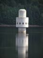
Extraction tower
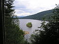
View from a higher point on the circular hiking trail
Lake from the back


See also
literature
- Frauenau drinking water reservoir (= water management in Bavaria. 17, ISSN 0721-6416 ). Supreme building authority in the Bavarian State Ministry of the Interior, Munich 1984.
- Peter Franke, Wolfgang Frey: Dams in the Federal Republic of Germany. Systemdruck, Berlin 1987, ISBN 3-926520-00-0 .
Web links
- Construction and operation of the Frauenau drinking water reservoir in the Bavarian Forest ( Memento from September 28, 2007 in the Internet Archive )
- Frauenau drinking water reservoir - master and quality data (PDF file; 334 kB)