
Great Rachel
| Great Rachel | ||
|---|---|---|
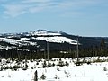
 Big Rachel in autumn |
||
| height | 1452 m above sea level NHN | |
| location | District of Regen , Freyung-Grafenau , Lower Bavaria | |
| Mountains | Bavarian forest | |
| Dominance | 23.8 km → Großer Arber | |
| Notch height | 496 m ↓ S of Nový Brunst | |
| Coordinates | 48 ° 58 '42 " N , 13 ° 23' 22" E | |
|
||
| rock | Gneiss | |

The Great Rachel is 1452 m above sea level. NHN is the second highest elevation in the Bavarian Forest or Bohemian Forest after the Great Arber and the highest mountain in the Bavarian Forest National Park . Together with Little Rachel , 900 m north-west, it forms Mount Rachel ( Roklan in Czech ).
description
On its rocky summit there is a stately wooden cross and a mountain guard hut . The panorama extends from the Osser and Arber in the north-west to the Dreisesselberg in the south-east; in the case of foehn influence or inversion weather conditions , the Alpine chain from the Dead Mountains to the Zugspitze can also be seen. In the meantime, this panoramic view is obstructed by growing spruce trees in the summit area . The Big Rachel is a popular destination. Hikers can rest and stop at or in the Waldschmidthaus below ; Since 2011, due to changed fire protection regulations, overnight stays are no longer possible.
As on neighboring Lusen , large parts of the forest on Rachel fell victim to the bark beetle from 1995 onwards . In line with the national park concept , no defensive measures were taken, and the dead trees were not removed. Instead, nature was left to its own devices and instead of the former, monotonous spruce forest , mixed forest is now growing back.
To the southeast of the summit is the Rachelsee around 400 meters below . The Rachel Chapel is also located on the slopes of the mountain. North-east of the mountain in the Rachel Forest ( Roklanský les ) in the Czech Republic are the source areas of the Kleiner Regen and the Großer Müllerbach ( Roklanský potok ).
The Rachel is the local mountain of Frauenau and Spiegelau . Its summit can only be reached on foot. Driving on the approaches with a mountain bike is not permitted. The shortest way to get to the summit is from the Gfung car park in 1½ hours. Other starting points are Oberfrauenau , the Klingenbrunn train station and the Racheldiensthütte car park. The access to the two parking spaces mentioned is closed from May 15 to November 2 between 8 a.m. and 6 p.m. and they can then only be reached with the Igelbusses of the Regionalbus Ostbayern . In winter, the mountain can often only be climbed with touring skis or snowshoes due to the meter-high snow . A direct ascent from the Czech side is no longer possible, as the traditional starting point, the Rachelhütte (Roklanská chata), is in the core zone of the Šumava National Park ( Maderer Filze nature reserve ) and is therefore prohibited from entering.
Geotope
The summit cliffs of the Großer Rachel are designated by the Bavarian State Office for the Environment as an important geotope (geotope number: 276R029).
Panoramas


Individual evidence
- ↑ Dominances and celebrities according to Highrisepages.de ( Memento from October 19, 2014 in the Internet Archive )
- ↑ Bavaria Atlas of the Bavarian State Government ( notes )
- ↑ Bavarian State Office for the Environment, Geotop summit cliffs of the Großer Rachel (accessed on October 18, 2017).
Web links

Look at the big Rachel
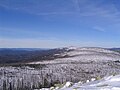
View from the Černá hora to Rachel

Great Rachel's summit cross
View from Lusen to Big Rachel


