
Rachelsee
| Rachelsee | ||
|---|---|---|

|
||
| Geographical location | in the Bavarian Forest | |
| Drain | Seebach → Ilz | |
| Data | ||
| Coordinates | 48 ° 58 ′ 31 ″ N , 13 ° 24 ′ 7 ″ E | |
|
||
| Altitude above sea level | 1070.5 m | |
| surface | 5.7 ha | |
| length | 350 m | |
| width | 205 m | |
| volume | 180,000 m³ | |
| Maximum depth | 13.2 m | |
| Middle deep | 3.2 m | |
| PH value | 5.0 | |
| Catchment area | 58 ha | |
|
particularities |
no fish or amphibians |
|

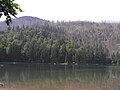
The Rachelsee is one of three Kar lakes of the Bavarian Forest . It is located in the far north of the municipality of Sankt Oswald-Riedlhütte . On the Czech side of this extensive forest area there are another five cirque lakes in the Bohemian Forest . The lakes and the surrounding area were declared a nature reserve in 1918 .
description
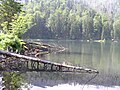
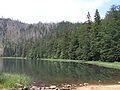
The Rachelsee at the foot and a good 800 meters southeast of the Großer Rachel is the quietest lake in the Bavarian Forest and can only be reached on footpaths. Like the Great Arbersee, it is dominated by a steep sea wall. Under the dark brown colored water surface there is a depth of 13.5 m. The 5.7 hectare lake is poor in aquatic animals due to its lack of calcium salts and soil acidification. Since no tree has been felled here since the establishment of the nature reserve, a primeval forest has formed around the lake that can only be crossed on a primeval forest nature trail .
The lake was created in the Würm as glacial cirque lake after the melting waters of the melted glacier Rachel through a wall of moraines were dammed. The geological subsoil consists mainly of gneiss . The sea wall rises in the north, and there is also a ten-meter-wide silting zone on the northern edge. The northern basin reaches a water depth of up to three meters, the southern one, separated by a rock barrier below the water level, up to 13 meters. The entire lake floor is lined with up to 6.5 meters thick, clayey-silty loose sediment, which is rich in wooden parts in its upper layers.
The front basin is dammed by a steeply sloping terminal moraine . The inflow and outflow is the Seebach, which has its source at about 1300 meters above sea level and is one of the source streams of the Große Ohe . Due to the protected location of the lake, the wind has little access, so that there is hardly any mixing of the uppermost water layers.
Because of its catchment area in the mountain spruce forest, the Rachelsee is naturally an acidic body of water due to the washed out humic acids . The pH value , normally around 5, fell to an average of 3.8 by 1987, but rose again to 5. In the lake, larvae of caddis flies , mud flies and dragonflies as well as various algae and microorganisms were found. The sparse aquatic plants mainly collect in the silting zone of the north bay. Problems have been identified Carex rostrata , deergrass and several species of moss.
The Rachelsee refuge is on the south bank. In the north, on a ledge a good 140 meters above Lake Rachel, is the Rachel Chapel , which can be reached via the Kapellensteig.
Development
The lake is already entered on the map of Philipp Apian from 1568. In 1835 it was raised about a meter to use it as a Triftklause. At that time, a drift canal was built between the Rachelsee and the moored Old Lake.
Probably the oldest drawing comes from Bernhard Grueber in the basic work The Bavarian Forest (Böhmerwald) by Bernhard Grueber and Adalbert Müller from the year 1846. There the Rachelsee is described as follows:
- “The greatest peculiarity of this mountain is the over 3000 'high lying lake, which is probably similar to that of the Dreisesselberg, but is still much more remote and gruesome. In a cauldron, to the bottom of which daylight can only penetrate with difficulty, even in midsummer, it spreads its deep black, melancholy water level, surrounded by untouched virgin forest. Thousands of dead trees stare up on the bank with dry, bleached branches, like skeletons of gigantic bodies, but thousands, thrown down by the storms, lie half-trunks buried in the Stygian floods. There is a legend that fish without eyes lived in the depths of Lake Rachel; the truth is that no living being is found in him. "
The reason for the large number of dead trees was the damming of the lake. As a result, the trees on the eastern bank were in the floodplain. After they died, they fell into the lake. There are many trees on the lake bottom today.
Gümbel 1868 and Thiem 1905 also mentioned the lack of fish. Gümbel, however, pointed out the presence of numerous small organisms in the lake, which was later confirmed repeatedly.
The 106.5 hectare nature reserve Rachel with Rachelsee was announced by the State Ministry of the Interior on June 20, 1950, StAnz. No. 25 created. It included Rachelsee, Seewand and Summit of Rachel. In 1970 it opened up in the Bavarian Forest National Park. He built an ice age educational trail on the lake.
A considerable number of legends entwine around the lake, which Reinhard Haller wrote down in 1983 in his book Nature and Landscape, Legends from the Bavarian Forest . All of these stories portray the lake as a home for enchanted souls who reappear when their peace and quiet are disturbed.
In 1989, Cletus Weilner and his crew undertook six diving descents into the lake, and another followed in 1995.
Photo gallery

Rachelsee
Rachelsee 2
Rachelsee
Rachelsee 2

.JPG)
.JPG)
.JPG)

See also
literature
- Cletus Weilner: The Ice Age Lakes of the Bavarian Forest , Regen 1997, ISBN 3-924943-04-4
- Bernhard Grueber , Adalbert Müller : Der Bavarian Forest (Böhmerwald) , Regensburg 1846, reprint 1993, Grafenau, Morsak Verlag, ISBN 3-87553-415-8
Web links
Bavarian Forest : Großer Arbersee | Little Arbersee | Rachelsee
Bohemian Forest : Černé jezero (Black Lake) | Čertovo jezero (Devil's Lake) | Jezero Laka (Lackensee) | Prášilské jezero (Stubenbacher Lake) | Plešné jezero (Plöckensteinsee)
Five other former Karseen, some on the German and some on the Czech side, are already completely silted up and mossed.