
Achslach
| coat of arms | Germany map | |
|---|---|---|

|
Coordinates: 48 ° 58 ' N , 12 ° 56' E |
|
| Basic data | ||
| State : | Bavaria | |
| Administrative region : | Lower Bavaria | |
| County : | rain | |
| Management Community : | Ruhmannsfelden | |
| Height : | 600 m above sea level NHN | |
| Area : | 30.06 km 2 | |
| Residents: | 939 (Dec. 31, 2019) | |
| Population density : | 31 inhabitants per km 2 | |
| Postal code : | 94250 | |
| Primaries : | 09929, 09905 | |
| License plate : | REG, VIT | |
| Community key : | 09 2 76 111 | |
| LOCODE : | DE ACL | |
| Community structure: | 27 districts | |
| Association administration address: | Schulstr. 25 94239 Ruhmannsfelden |
|
| Website : | ||
| Mayoress : | Gabriele Wittenzellner, 1st Mayor (Independent Christian Democrats) | |
| Location of the municipality of Achslach in the Regen district | ||
  |
||

Achslach ( Bavarian : Oxla ) is a municipality in the Lower Bavarian district of Regen . The community is a member of the Ruhmannsfelden administrative association .
geography
Geographical location
Achslach is located in the Danube Forest region in the middle of the Bavarian Forest at the foot of the Hirschenstein in the Teisnach valley, about 18 kilometers north of Deggendorf , 14 kilometers south of Viechtach and 19 kilometers west of the district town of Regen .

Community structure
There are 27 districts
Neighboring communities
The following municipalities border the municipality of Achslach:
|
To the north and east of the Regen district : |
South of the Deggendorf district : |
To the west of the Straubing-Bogen district : |
history

Until the church is planted
The Achslacher valley is located in the so-called Karolinger Wald (northern forest) which was settled from the Metten monastery from the 9th century . In the 11th century this activity was taken over by the Counts of Bogen .
Achslach was mentioned for the first time in 1115 under the name Drasloha . At that time, the Ministeriale Eppo de Drasloha appeared in the entourage of Count Adalbert I. von Bogen on a deed of foundation of the Oberalteich monastery . Subsequently, in agreement with the Metten Monastery, a count's chamber property was created here, administered by Eppo . On December 11th, 1126, Eppo de Drahsala was again named as a witness on a deed of foundation for the Oberalteich monastery issued by Pope Honorius II in the Lateran in Rome .
After the Counts of Bogen died out in 1242, the area became the property of the Wittelsbach family .
In 1409, a letter of inheritance, sealed by the knight Eberhard the Nussberger, reported that the chamber property had a tolerable tavern (beer tavern ) attached to it.
In a document from the year 1431 the knight Hans von left Degen mountain the monastery Gotteszell the hunting ground (hunting law) in the Oxla.
In 1464 Achslach became the seat of a main team . It was also the seat of an official of the five offices of the district court Viechtach (Oberamt Viechtach , Amt Riedern, Mitteramt Böbrach , Amt Achslach and Amt Prackenbach ). The main teams Achslach, Allersdorf, Kogl, Haidenberg, Zachenberg , Tafertsried, Grün, Frath, Randsburg (formerly Wildenrandtsperg) and the Hofmark Lindenau belonged to the Achslach office . The bailiff had his seat in the electoral office. As one of the few places in the district, Achslach still had a patrimonial court in the 17th century with a bailiff as judge and an executioner. The field name Galgenwiesel at the exit to Gotteszell still testifies to this time.
Achslach belonged to the Straubing Rent Office and the Viechtach Regional Court of the Electorate of Bavaria . In the course of the administrative reforms in Bavaria , today's municipality was created with the municipal edict of 1818 . Achslachs was raised to parish in 1818.
Administrative community
In the course of the Bavarian regional reform , Achslach became a member of the Ruhmannsfelden administrative association on May 1, 1978 .
Naming
The place name changed from Drasloha in 1115 via Drahsala (1126), Drahsla (1310) and Achszlach (1431) to the current version Achslach , which was first mentioned in 1527.
The vernacular usage shows that Achslach is an old field name that describes the entire Au through which the Teisnach flows: in the Oxla means in the Achslach . At that time the Gotteszeller area was also counted as part of the Oxla . The dialect ( Oxla ) gives the forms with the palate ( x ) of 1126 and 1310 the predominance. The basic word is Ach (shortened to –a ) which means water, big brook . The qualifying expression must obviously at that font ahsal (1126), in the vernacular Oxl and today armpit loud. Achslach means the high Ache or the Hochau , as a valley through which water flows was usually referred to as Au. The reason for the beginning of the older name forms up to 1310 with Dr- is the drafting of the documents and other documents in the Latin language. The German in der Achslach in Latin, which doesn't know a gender word , became in drahsala , from Achslach to de drahsala .
Population development
Between 1988 and 2018 the population decreased from 1,112 to 921 by 191 inhabitants or 17.2%.
|
|
politics
Municipal council
Composition of the municipal council in the 2014–2020 legislative period:
- CSU / Free Voters Achslach: 7 seats (55.2% of the vote)
- Independent Christian Democrats (UCD): 5 seats (44.8% of the vote)
mayor
Mayor is Gabriele Wittenzellner (Independent Christian Democrats).
coat of arms
Description : A silver wave bar in blue, two golden pilgrim sticks crossed at an angle at the top, covered with a silver pilgrim shell, and below a gold-reinforced silver ibex trunk.
The municipality was under the sovereignty of the Counts of Bogen until 1242 and then came with their inheritance to the House of Wittelsbach (court and caste office Viechtach). The colors silver and blue are reminiscent of this connection. The silver wave arch stands for the Achslach valley of the Teisnach . Shell and pilgrim sticks refer to the Achslach church patron St. Jakobus . The gold-reinforced silver ibex trunk represents the reduced coat of arms of the Ramsbergers, who were resident in the district of Randsburg as former ministerials of the Counts of Bogen .
Buildings
- Catholic parish church St. Jakobus (1833, tower basement medieval, high altar around 1720, baroque full-body relic of the catacomb saint Hilarius on the side altar, historical Edenhofer organ from 1854)
- Lourdes grotto on the Kirchberg (around 1900)
- Chapel in Lindenau , second half of the 18th century, with baroque reliquary pyramids (around 1720) on the altar
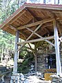
- Wooden chapel (around 1848) on the Oedwies (1030 m above sea level) with former forester's house (around 1848)
- On the local mountain of Achslach, the 1095 meter high Hirschenstein , there is an observation tower from which one has a view of the Bavarian Forest, the Danube Valley and the Alps.
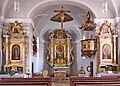
Interior view of the parish church of St. Jakobus Achslach
Lourdes grotto on the Kirchberg

Interior view of the chapel in Lindenau

Chapel on the Oedwies
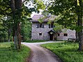
Forsthaus Oedwies

Lookout tower on the Hirschenstein


Soil monuments
statistics
In 1998 there were 85 employed in agriculture and forestry, in manufacturing and in trade and transport. 51 people were employed at the place of work in other economic sectors. There were a total of 371 employees at the place of residence. There was one company in manufacturing (as well as mining and quarrying of stones and earth) and three companies in the main construction trade. In addition, in 1999 there were 69 farms with an agricultural area of 729 hectares. Of this, 60 hectares were arable land and 669 hectares were permanent green space. The municipal tax receipts amounted to the equivalent of 264,000 euros in 1999, of which the trade tax receipts (net) amounted to the equivalent of 17,000 euros.
traffic
Achslach is accessible through the district roads REG 11 (Achslach - Kalteck - Metten / Deggendorf ) and REG 14 ( Viechtach - B 85 - Achslach - Gotteszell - B 11 ). The A 3 motorway is 17 km away (Metten exit) and the A 92 is 18 km ( Deggendorf A 3 / A 92 motorway junction ). The next stop of the forest railway (Plattling-Bayerisch Eisenstein line) is in Gotteszell train station, five kilometers away .
education
The following facilities exist (as of 2018):
- Kindergarten St. Jakob with 29 kindergarten places and integrated crèche group
Personalities
- Emmanuela Aichinger (1917–2005), Abbess of the Tettenweis Monastery
- Paul Johannes Baumgartner (* 1969), German radio presenter and communication trainer
Web links
- Homepage
- Entry on the coat of arms of Achslach in the database of the House of Bavarian History
Individual evidence
- ↑ "Data 2" sheet, Statistical Report A1200C 202041 Population of the municipalities, districts and administrative districts 1st quarter 2020 (population based on the 2011 census) ( help ).
- ^ Achslach community: administration. Mayoress. Retrieved May 9, 2020 .
- ↑ place database. Achslach. In: Bayerische Landesbibliothek Online. Bavarian State Library, accessed on April 27, 2014 .
- ↑ Monumenta Boica, Volume 12, 1775, p. 31
- ↑ Monumenta Boica, Volume 12, 1775, p. 327
- ^ Historical Atlas of Bavaria, Volume Altbayern Series I, Issue 18, 1968, p. 201
- ^ District Regen (Ed.): The District Regen - Home in the Bavarian Forest , ISBN 3-87553-194-9
- ^ Anne-Rose Baumgartner: Achslach und seine Gemeinwesen 1892-1992 , March 1996
- ^ Anton Trellinger (Hrsg.): Contributions to the history of the individual places in the municipality of Achslach , Buchdruckerei Nothaft Deggendorf
- ↑ Alois Zimmermann (Ed.): Local history Achslach 1115–1972
- ^ The Bavarian Forest - Willibald Schmidt: Drachselsried or Achslach? - A contribution to the history of place names , 23rd year, June 1925, issue 6

Achslach | Arnbruck | Bayerisch Eisenstein | Bishop corn | Böbrach | Ground corn | Drachselsried | Frauenau | Geiersthal | Gotteszell | Kirchberg in the forest | Kirchdorf im Wald | Kollnburg | Langdorf | Lindberg | Patersdorf | Prackenbach | Rain | Rinchnach | Ruhmannsfelden | Teisnach | Viechtach | Zachenberg | Zwiesel