
Patersdorf
| coat of arms | Germany map | |
|---|---|---|

|
Coordinates: 49 ° 1 ′ N , 12 ° 59 ′ E |
|
| Basic data | ||
| State : | Bavaria | |
| Administrative region : | Lower Bavaria | |
| County : | rain | |
| Height : | 503 m above sea level NHN | |
| Area : | 17.04 km 2 | |
| Residents: | 1751 (Dec. 31, 2019) | |
| Population density : | 103 inhabitants per km 2 | |
| Postal code : | 94265 | |
| Area code : | 09923 | |
| License plate : | REG, VIT | |
| Community key : | 09 2 76 134 | |
| Community structure: | 28 districts | |
| Address of the municipal administration: |
Martinsplatz 10 94265 Patersdorf |
|
| Website : | ||
| Mayor : | Günther Strenz ( FW "Bürgerblock" ") | |
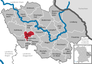
| Location of the municipality of Patersdorf in the Regen district | ||
  |
||


Patersdorf is a municipality in the Lower Bavarian district of Regen in the middle of the Bavarian Forest .
geography
Geographical location
Patersdorf is located in the Danube Forest region in Teisnachtal in the middle of the Bavarian Forest nature park, right at the intersection of federal roads 11 and 85, around eleven kilometers southeast of Viechtach , 22 km north of Deggendorf , 13 km northwest of the district town of Regen and 23 km from Zwiesel . Patersdorf does have a Regentalbahn AG stop on the Gotteszell – Blaibach railway line , but this line , which only leads to Viechtach, is only used for tourist excursions in summer. The nearest Waldbahn train station with hourly connections to Plattling and Bayerisch Eisenstein is in Gotteszell, six kilometers away .
Community structure
Patersdorf has 28 districts:
There is only the Patersdorf district .
history
Until the first documentary mention
Patersdorf belonged to the Rentamt Straubing and the district court Viechtach .
Today's municipality is likely to have been settled around the 8th and 9th centuries. The main evidence is the place names on -dorf, which are typical for this clearing time .
The first references to a church in Patersdorf with St. Martin as patron date back to the 9th century.
The place is first mentioned in a document in the so-called "Herzogsurbar" from the years 1301 and 1307.
Population development
Between 1988 and 2018 the municipality grew from 1,674 to 1,718 by 44 inhabitants or 2.6%.
- 1961: 1519 inhabitants
- 1970: 1654 inhabitants
- 1987: 1699 inhabitants
- 1991: 1788 inhabitants
- 1995: 1812 inhabitants
- 2000: 1782 inhabitants
- 2005: 1830 inhabitants
- 2010: 1774 inhabitants
- 2015: 1672 inhabitants
politics
Municipal council
Since the local elections on March 16, 2014, the municipal council has been composed as follows:
- CSU : 5 seats (39.90% of the vote)
- Independent electoral association : 3 seats (21.76% of the vote)
- FWG Bürgerblock : 2 seats (19.29% of the vote)
- SPD : 2 seats (19.05% of the vote)
mayor
Günther Strenz (FW "Bürgerblock") has been mayor since 2020. In the runoff election for the local elections in Bavaria 2020 , he prevailed on March 29, 2020 with 60.1 percent against Richard Krauer (FW).
Willi Dietl (CSU) was mayor of Patersdorf from 208 to 2020, re-elected in 2014 with 90.52% of the vote. Before that, Franz Plötz was mayor for 18 years.
Finances
The municipal tax income in 2007 amounted to EUR 1,838 thousand , of which the trade tax income (net) amounted to EUR 160 thousand.
coat of arms
Description : A golden arrow and a golden sword crossed diagonally in blue under a raised silver cap and above stacked granite blocks. The old heraldic symbol of the "Göpel" symbolizes in the coat of arms of Patersdorf the meeting of two important federal highways that make Patersdorf a local traffic junction. The sword and arrow refer to the parish church. She is the St. Martin consecrated (attribute: sword) and has an old pilgrimage to St. Sebastian (attribute: arrow). The granite blocks in the lower part of the shield refer to the quarries in the municipality (granite industry) and to the natural monument of the stake.
The silver-blue tinging reminds us that Patersdorf was always part of the Duchy and Electorate of Bavaria (Viechtach Regional Court).
Culture and sights
- "Panoramablick" nature experience trail
- Parish Church of St. Martin. It was built in 1723 and has a late Gothic choir and a tower from 1893. The furnishings are uniform in the Rococo style .
statistics
According to official statistics, there were six in the field of agriculture and forestry in 1998, 175 in the manufacturing sector and 40 in the trade and transport sector at the place of work. In other economic areas, 26 people were employed at the place of work subject to social security contributions. There were a total of 574 employees at the place of residence subject to social security contributions. There were three companies in the manufacturing sector and three in the construction sector. In addition, in 1999 there were 57 farms with an agriculturally used area of 749 hectares, of which 119 hectares were arable land and 629 hectares were permanent green areas.
Infrastructure
traffic
Patersdorf is on the federal highways 11 (Europastraße 53) from Bayerisch Eisenstein to Deggendorf and 85 from Cham to Passau .
education
There are the following facilities
- Kindergarten with two morning and one afternoon groups
- Primary school with grades 1 to 4
Sports
The soccer team SpVgg Patersdorf, which celebrated its 50th anniversary in 2009, became champions of the A-class in Viechtach / Kötzting in 2011 and is promoted to the district class. The winter sports club WSV Patersdorf provides the opportunity for sportive leisure activities in summer with the running club and in winter with ski gymnastics and the preparation of the cross-country ski trails in Schön and in the Grünbach area in the municipality. In addition, alpine racing training is actively carried out in the junior area.
Individual evidence
- ↑ "Data 2" sheet, Statistical Report A1200C 202041 Population of the municipalities, districts and administrative districts 1st quarter 2020 (population based on the 2011 census) ( help ).
- ^ Community Patersdorf in the local database of the Bavarian State Library Online . Bayerische Staatsbibliothek, accessed on January 5, 2018.
- ↑ a b wahl.info - candidates & results
- ↑ The run-off elections on Sunday, 29 March 2020. In: Wahl.info. March 30, 2020, accessed March 30, 2020 .
Web links
- Entry on the Patersdorf coat of arms in the database of the House of Bavarian History

Achslach | Arnbruck | Bayerisch Eisenstein | Bishop corn | Böbrach | Ground corn | Drachselsried | Frauenau | Geiersthal | Gotteszell | Kirchberg in the forest | Kirchdorf im Wald | Kollnburg | Langdorf | Lindberg | Patersdorf | Prackenbach | Rain | Rinchnach | Ruhmannsfelden | Teisnach | Viechtach | Zachenberg | Zwiesel