
District of Ochsenfurt
| coat of arms | Germany map | |
|---|---|---|

|
Coordinates: 49 ° 40 ' N , 10 ° 5' E |
|
| Basic data (as of 1972) | ||
| Existing period: | 1939-1972 | |
| State : | Bavaria | |
| Administrative region : | Lower Franconia | |
| Administrative headquarters : | Ochsenfurt | |
| Area : | 372.05 km 2 | |
| Residents: | 35,623 (May 27, 1970) | |
| Population density : | 96 inhabitants per km 2 | |
| License plate : | OCH | |
| Circle key : | 09 6 50 | |
| Circle structure: | 53 municipalities | |
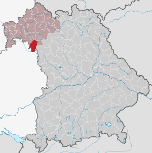
| Location of the district of Ochsenfurt in Bavaria | ||
  |
||


The district of Ochsenfurt was a district in the Bavarian administrative district of Lower Franconia . It was dissolved in the territorial reform in 1972 .
geography
location
The district of Ochsenfurt mainly comprised the Ochsenfurter Gau and thus the southern part of today's district of Würzburg .
Area and population
Before its dissolution, the district of Ochsenfurt had approx. 35,500 inhabitants and thus remained far below the 80,000 inhabitants determined by the regional reform for the formation of a separate district.
Most important places
The most populous communities in the district were Ochsenfurt , Giebelstadt , Eibelstadt and Gaukönigshofen .
Neighboring areas
In 1972 the district bordered clockwise in the north, beginning with the district and the independent city of Würzburg , the district and the independent city of Kitzingen and the district of Uffenheim (all in Bavaria) and the districts of Bad Mergentheim and Tauberbischofsheim (both in Baden-Württemberg ).
history
District Office
The district office of Ochsenfurt was formed in 1862 through the merger of the regional courts of the older order of Aub and Ochsenfurt .
On the occasion of the reform of the layout of the Bavarian district offices, the Ochsenfurt district office ceded the Geroldshausen community to the Würzburg district office on January 1, 1880 .
From 1935 to 1941, Hermann Kraus was district administrator or district administrator.
During the National Socialist era , the administrative district was renamed Mainfranken on July 1, 1937 .
district
On January 1, 1939, the uniform designation Landkreis was introduced in the German Reich . This is how the district office became the district of Ochsenfurt.
On July 1, 1972, the district was dissolved in the course of the regional reform in Bavaria and incorporated into the district of Würzburg .
Population development
| year | Residents | source |
|---|---|---|
| 1864 | 25,624 | |
| 1885 | 26,190 | |
| 1900 | 26,062 | |
| 1910 | 27,136 | |
| 1925 | 26,875 | |
| 1939 | 29,422 | |
| 1950 | 40,806 | |
| 1960 | 35,200 | |
| 1971 | 35,500 |
Communities
53 communities belonged to the district:
|
License Plate
On July 1, 1956, the district was assigned the distinctive sign OCH when the vehicle registration number that is still valid today was introduced . It was issued until April 30, 1973. Since July 10, 2013, it has been available again in the Würzburg district due to the license plate liberalization .
Individual evidence
- ^ Wilhelm Volkert (ed.): Handbook of Bavarian offices, communities and courts 1799–1980 . CH Beck, Munich 1983, ISBN 3-406-09669-7 , p. 545 .
- ^ Wilhelm Volkert (ed.): Handbook of Bavarian offices, communities and courts 1799–1980 . CH Beck, Munich 1983, ISBN 3-406-09669-7 , p. 97 .
- ^ Federal Statistical Office (ed.): Historical municipality directory for the Federal Republic of Germany. Name, border and key number changes in municipalities, counties and administrative districts from May 27, 1970 to December 31, 1982 . W. Kohlhammer, Stuttgart / Mainz 1983, ISBN 3-17-003263-1 , p. 752 .
- ^ Eugen Hartmann: Statistics of the Kingdom of Bavaria . Ed .: Royal Bavarian Statistical Bureau. Munich 1866, population of the district offices 1864, p. 106 ( digitized version ).
- ↑ Royal Bavarian Statistical Bureau (ed.): Localities directory of the Kingdom of Bavaria . Munich 1888, population figures of the district offices 1885 ( digitized ).
- ↑ a b www.gemeindeververzeichnis.de: Lower Franconia
- ↑ for the Free State of Bavaria, according to the census of June 16, 1925
- ↑ Statistical Yearbook for the German Reich 1940
- ↑ Statistical Yearbook for the Federal Republic of Germany 1952
- ↑ Statistical Yearbook for the Federal Republic of Germany 1961
- ↑ Statistical Yearbook for the Federal Republic of Germany 1973
Aichach | Alzenau i.UFr. | Amberg | Bad Aibling | Bad Neustadt adSaale | Bad Toelz | Beilngries | Berchtesgaden | Bow | Brückenau | Burglengenfeld | Dingolfing | Dinkelsbühl | Donauwörth | Ebermannstadt | Boars | Eggenfelden | Erlangen | Eschenbach idOPf. | Feuchtwangen | Friedberg | Feet | Gemünden a.Main | Gerolzhofen | Grafenau | Griesbach i.Rottal | Gunzenhausen | Hammelburg | Hassfurt | Hersbruck | Hilpoltstein | Höchstadt adAisch | Hofheim i.UFr. | Illertissen | Ingolstadt | Karlstadt | Kaufbeuren | Kemnath | Kempten (Allgäu) | Königshofen i.Grabfeld | Kötzting | Krumbach (Swabia) | Landau adIsar | Lauf adPegnitz | Running | Lohr a.Main | Mainburg | Mallersdorf | Marktheidenfeld | Marktoberdorf | Mellrichstadt | Memmingen | Mindelheim | Münchberg | Nabburg | Naila | Neuburg adDonau | Neunburg vorm Wald | Neustadt adAisch | Nordlingen | Nuremberg | Obernburg am Main | Oberviechtach | Ochsenfurt | Parsberg | Pegnitz | Parish churches | Rehau | Riedenburg | Roding | Rothenburg ob der Tauber | Rottenburg adLaaber | Scheinfeld | Schongau | Schrobenhausen | Schwabach | Schwabmünchen | Sonthofen | Stadtsteinach | Staffelstein | Straubing | Sulzbach-Rosenberg | Uffenheim | Viechtach | Vilsbiburg | Vilshofen | Vohenstrauss | Waldmünchen | Wasserburg a.Inn | Wegscheid | Weilheim i.OB | Weißenburg i.Bay. | Wertingen | Wolfratshausen | Wolfstein
1939–1945 affiliated districts: Bergreichenstein | Eisenstein market | Prachatitz