
Hammelburg district
| coat of arms | Germany map | |
|---|---|---|

|
Coordinates: 50 ° 7 ' N , 9 ° 54' E |
|
| Basic data (as of 1972) | ||
| Existing period: | 1862-1972 | |
| State : | Bavaria | |
| Administrative region : | Lower Franconia | |
| Administrative headquarters : | Hammelburg | |
| Area : | 350.61 km 2 | |
| Residents: | 27,700 (Dec. 31, 1971) | |
| Population density : | 79 inhabitants per km 2 | |
| License plate : | HAB | |
| Circle key : | 09 6 39 | |
| Circle structure: | 35 municipalities | |
| Address of the district administration: |
8783 Hammelburg | |
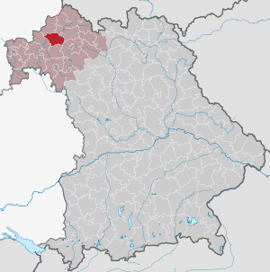
| Location of the Hammelburg district in Bavaria | ||
  |
||

The district of Hammelburg was part of the Bavarian administrative district of Lower Franconia . Before the Bavarian regional reform began in the early 1970s, the district comprised 35 municipalities.
geography
Important places
The communities with the largest population were Hammelburg , Euerdorf and Sulzthal .
Neighboring areas
The district bordered clockwise in 1972 in the north, beginning with the districts of Bad Brückenau , Bad Kissingen , Schweinfurt , Karlstadt and Gemünden am Main .
history
District Office
The Hammelburg district office was formed in 1862 through the merger of the older district courts of Euerdorf and Hammelburg .
On the occasion of the reform of the layout of the Bavarian district offices, the Hammelburg district office ceded municipalities to the Kissingen district office on January 1, 1880.
district
On January 1, 1939, the uniform designation Landkreis was introduced in the German Reich . So the district office became the Hammelburg district.
On September 21, 1943, the Hammelburg district was enlarged to include the Bonnland community in the Karlstadt district. This was dissolved and incorporated into the Hammelburg Army Estate District (see: Hammelburg military training area ). On April 1, 1949, it was spun off from the disbanded Hammelburg Army District of the Hammelburg district and re-established as an independent municipality in the Karlstadt district.
On July 1, 1972, the Hammelburg district was dissolved as part of the regional reform in Bavaria . The communities Greßthal and Wasserlosen came to the district of Schweinfurt. The rest of the district has been with the district of Bad Brückenau , the independent city of Bad Kissingen , field parts of the county Gemünden am Main and two municipalities in the district Karlstadt the Bad Kissingen district struck.
Population development
| year | Residents | source |
|---|---|---|
| 1864 | 21,931 | |
| 1885 | 20,529 | |
| 1900 | 19,467 | |
| 1910 | 19,957 | |
| 1925 | 20,906 | |
| 1939 | 19,201 | |
| 1950 | 28,012 | |
| 1960 | 25,200 | |
| 1971 | 27,700 |
Communities
The Hammelburg district comprised 35 municipalities until the regional reform. The Hundsfeld community had to give way to the Hammelburg military training area and was dissolved in 1943.
|
Other communities |
License Plate
On July 1, 1956, the district was assigned the distinctive sign HAB when the vehicle registration number that is still valid today was introduced . It was issued until April 28, 1973. Since July 10, 2013, it has been available again in the Bad Kissingen district due to the license plate liberalization .
literature
- Günther U. Müller (ed.): Our district Hammelburg. Publishing house Bild + Druck, Munich 1972.
- Karl Fell: The district of Hammelburg 1862 - 1972. Bad Kissingen 1989.
- Josef Kirchner: Hammelburg, city and district. 1303-1992, 1862-1972. Kaiser, Hammelburg 1992.
Individual evidence
- ^ Official register of places for Bavaria 1964
- ^ Wilhelm Volkert (ed.): Handbook of Bavarian offices, communities and courts 1799–1980 . CH Beck, Munich 1983, ISBN 3-406-09669-7 , p. 434 .
- ^ Wilhelm Volkert (ed.): Handbook of Bavarian offices, communities and courts 1799–1980 . CH Beck, Munich 1983, ISBN 3-406-09669-7 , p. 97 .
- ^ Federal Statistical Office (ed.): Historical municipality directory for the Federal Republic of Germany. Name, border and key number changes in municipalities, counties and administrative districts from May 27, 1970 to December 31, 1982 . W. Kohlhammer, Stuttgart / Mainz 1983, ISBN 3-17-003263-1 , p. 744 .
- ^ Ordinance on the reorganization of Bavaria into rural districts and independent cities of December 27, 1971
- ^ Eugen Hartmann: Statistics of the Kingdom of Bavaria . Ed .: Royal Bavarian Statistical Bureau. Munich 1866, population of the district offices 1864, p. 106 ( digitized version ).
- ↑ Royal Bavarian Statistical Bureau (ed.): Localities directory of the Kingdom of Bavaria . Munich 1888, population figures of the district offices 1885 ( digitized ).
- ↑ a b www.gemeindeververzeichnis.de: Lower Franconia
- ↑ for the Free State of Bavaria, according to the census of June 16, 1925
- ↑ Statistical Yearbook for the German Reich 1940
- ↑ Statistical Yearbook for the Federal Republic of Germany 1952
- ↑ Statistical Yearbook for the Federal Republic of Germany 1961
- ↑ Statistical Yearbook for the Federal Republic of Germany 1973
Aichach | Alzenau i.UFr. | Amberg | Bad Aibling | Bad Neustadt adSaale | Bad Toelz | Beilngries | Berchtesgaden | Bow | Brückenau | Burglengenfeld | Dingolfing | Dinkelsbühl | Donauwörth | Ebermannstadt | Boars | Eggenfelden | Erlangen | Eschenbach idOPf. | Feuchtwangen | Friedberg | Feet | Gemünden a.Main | Gerolzhofen | Grafenau | Griesbach i.Rottal | Gunzenhausen | Hammelburg | Hassfurt | Hersbruck | Hilpoltstein | Höchstadt adAisch | Hofheim i.UFr. | Illertissen | Ingolstadt | Karlstadt | Kaufbeuren | Kemnath | Kempten (Allgäu) | Königshofen i.Grabfeld | Kötzting | Krumbach (Swabia) | Landau adIsar | Lauf adPegnitz | Running | Lohr a.Main | Mainburg | Mallersdorf | Marktheidenfeld | Marktoberdorf | Mellrichstadt | Memmingen | Mindelheim | Münchberg | Nabburg | Naila | Neuburg adDonau | Neunburg vorm Wald | Neustadt adAisch | Nordlingen | Nuremberg | Obernburg am Main | Oberviechtach | Ochsenfurt | Parsberg | Pegnitz | Parish churches | Rehau | Riedenburg | Roding | Rothenburg ob der Tauber | Rottenburg adLaaber | Scheinfeld | Schongau | Schrobenhausen | Schwabach | Schwabmünchen | Sonthofen | Stadtsteinach | Staffelstein | Straubing | Sulzbach-Rosenberg | Uffenheim | Viechtach | Vilsbiburg | Vilshofen | Vohenstrauss | Waldmünchen | Wasserburg a.Inn | Wegscheid | Weilheim i.OB | Weißenburg i.Bay. | Wertingen | Wolfratshausen | Wolfstein
1939–1945 affiliated districts: Bergreichenstein | Eisenstein market | Prachatitz