
Dingolfing district
| coat of arms | Germany map | |
|---|---|---|

|
Coordinates: 48 ° 38 ' N , 12 ° 30' E |
|
| Basic data (as of 1972) | ||
| Existing period: | 1862-1972 | |
| State : | Bavaria | |
| Administrative region : | Lower Bavaria | |
| Administrative headquarters : | Dingolfing | |
| Area : | 414.61 km 2 | |
| Residents: | 34,900 (Dec. 31, 1971) | |
| Population density : | 84 inhabitants per km 2 | |
| License plate : | DGF | |
| Circle key : | 09 2 33 | |
| Circle structure: | 19 municipalities | |
| Address of the district administration: |
8312 Dingolfing | |
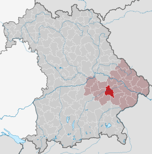
| Location of the district of Dingolfing in Bavaria | ||
  |
||

The district of Dingolfing was a district in Lower Bavaria , which was added to the district of Dingolfing-Landau in 1972 .
geography
location
The area of the former district of Dingolfing naturally belongs to the Lower Bavarian hill country and is traversed by the river valleys of Aiterach , Isar , Vils and Kollbach , running approximately parallel from west to east .
Neighboring areas
Starting in 1972, the district bordered clockwise in the northwest on the districts of Mallersdorf , Straubing , Landau an der Isar , Eggenfelden , Vilsbiburg and Landshut .
history


Before 1862
The area of today's district of Dingolfing-Landau belonged in Roman times to the Roman province of Raetia or to its later sub-province of Vindelicia with its seat in Augusta Vindelicorum ( Augsburg ). More than 1000 years ago the area belonged to the Elder Baier Tribal Duchy . In 1803, the Landau an der Isar district court was established in the district , which from 1808 belonged to the Lower Danube District . The western and southern areas, formerly Teisbach Regional Court , belonged to the Vilsbiburg Regional Court . The regional courts of Dingolfing and Osterhofen were established in 1838 from parts of its territory . All regional courts then belonged to the Lower Bavaria district . When the Dingolfing Regional Court was re-established in 1838, Vilsbiburg had to surrender the communities of Dornwang, Loiching, Marklkofen, Niederviehbach and Teisbach. Most of the communities, however, came from the Landau Regional Court to the re-established Dingolfing Regional Court.
District Office
In 1862, in the course of the separation of justice and administration at the lower level, the district offices of Dingolfing and Landau were created in addition to the previous regional court districts of the same name, with the regional court of Dingolfing ceding some communities that from then on formed the judicial district of Arnstorf, which was assigned to the district office of Eggenfelden. It should be noted that "Bezirksamt" in the Bavarian administrative language corresponded to today's district, while "Kreis" meant the middle administrative level, i.e. today's "district". The Osterhofen area was part of the Vilshofen district office.
district
On January 1, 1939, the designation district was introduced as everywhere else in the German Reich . This is how the district office became the district of Dingolfing.
Community consolidation
The community Hackerskofen was incorporated into Gottfrieding in 1946 . The incorporation of Weichshofen into Mengkofen, also carried out in 1946 by order of the local department of the US military government (in 1946 the former district had only 31 parishes), was reversed between 1947 and 1949. Up to December 31, 1970 the district had 32 parishes.
As part of the regional reform in Bavaria , 19 additional municipalities were dissolved from January 1, 1971 to January 1, 1972, and the Dingolfing district had only 13 municipalities on the eve of its dissolution.
District reform
On July 1, 1972, the district of Dingolfing was dissolved and fully integrated into the district of Untere Isar . This was renamed on May 1, 1973 in the district of Dingolfing-Landau . In addition there were municipalities of the former districts of Vilsbiburg ( Frontenhausen and Rampoldstetten , which was incorporated into Frontenhausen on May 1, 1978) and Mallersdorf ( Martinsbuch , which was incorporated into Mengkofen on July 1, 1972, as well as Mühlhausen and Süsskofen , which on May 1 1978 after Mengkofen were incorporated). Other communities were incorporated or outsourced on the outskirts of the Landau an der Isar district.
Population development
| year | Residents | source |
|---|---|---|
| 1864 | 20,717 | |
| 1885 | 23,049 | |
| 1900 | 22,087 | |
| 1910 | 23.207 | |
| 1925 | 24,300 | |
| 1939 | 24,683 | |
| 1950 | 35,347 | |
| 1960 | 34,100 | |
| 1971 | 34,900 |
politics
On May 2, 1945, the American military government appointed the book printer Anton Maier as district administrator in Dingolfing. In the following year, the district council was elected democratically for the first time, which elected Kurt Lückenhaus on June 26, 1946 and Robert Kaufmann two years later as district administrator. A district administrator was not directly elected until 1952: Josef Hastreiter was district administrator of the Dingolfing district until 1972. With 49.8 percent of the vote, he was defeated by Fritz Ettengruber in 1972 , who thus became the first district administrator in the Untere Isar district .
Communities
Originally the district or the district office had 33 municipalities . The official municipality key introduced in Bavaria in 1954 was 09233 (09 for Bavaria , 2 for the administrative district of Lower Bavaria, and 33 for the district within the administrative district).
Before the start of the regional reform in Bavaria in 1971, the district of Dingolfing had 32 communities. For the sake of completeness, the following table also lists Hackerskofen , which was dissolved on January 1, 1946 . This means that all 33 communities originally existing in the Dingolfing district are listed. The area data and the population figures come from the official municipal statistics of the 1961 census, since the results of the subsequent census of 1970, which were published in 1973, already took into account the amalgamation of municipalities up to 1973. The figures for the municipality of Hackerskofen, which was dissolved in 1946, were calculated from Gottfrieding using the area statistics from 1925 and the local directory from 1961.

(32 municipalities as of
June 6, 1961, i.e. excluding Hackerskofen,
which is in the eastern part of Gottfrieding).
This territorial status was largely stable from January 1, 1946 to December 31, 1970, apart from minor border shifts between individual municipalities.
| AGS | (Former) parish |
Area ha |
Population 1961 |
incorporated on |
incorporated after |
|---|---|---|---|---|---|
| 09233111 | Bubach | 1481.85 | 448 | 01/01/1972 | Mamming |
| 09233112 | Dingolfing | 1800.77 | 10456 | persisting | |
| 09233113 | Dornwang | 863.27 | 426 | 01/01/1972 | Lengthal |
| 09233114 | Englmannsberg | 1350.23 | 453 | 04/01/1971 | Reisbach |
| 09233115 | Frauenbiburg | 2306.78 | 887 | 01/01/1972 | Dingolfing , Marklkofen |
| 09233116 | Gottfrieding | 2474.49 | 1199 | persisting | |
| 09233117 | Griesbach | 1586.57 | 733 | 01/01/1972 | Reisbach |
| 09233118 | Haberskirchen | 2087.65 | 819 | 05/01/1978 | Reisbach |
| Hackerskofen | 233.23 | 127 | 01/01/1946 | Gottfrieding | |
| 09233119 | Hofdorf | 968.91 | 387 | 01/01/1972 | Mengkofen |
| 09233120 | Hüttenkofen | 697.98 | 306 | 05/01/1978 | Mengkofen |
| 09233121 | Lengthal | 1911.95 | 866 | 05/01/1978 | Moosthenning |
| 09233122 | Loiching | 1127.88 | 1155 | persisting | |
| 09233123 | Mamming | 2667.71 | 1652 | persisting | |
| 09233124 | Marklkofen | 1276.05 | 1234 | persisting | |
| 09233125 | Mengkofen | 458.18 | 853 | persisting | |
| 09233126 | Moosthenning | 618.10 | 434 | persisting | |
| 09233127 | Niederreisbach | 1031.46 | 699 | 04/01/1971 | Reisbach |
| 09233128 | Niederviehbach | 1908.87 | 1591 | persisting | |
| 09233129 | Oberviehbach | 1054.01 | 398 | 04/01/1971 | Niederviehbach |
| 09233130 | Ottering | 1731.35 | 769 | 05/01/1978 | Moosthenning |
| 09233131 | Poxau | 999.60 | 603 | 01/01/1971 | Marklkofen |
| 09233132 | Puchhausen | 1181.92 | 469 | 01/01/1972 | Mengkofen |
| 09233133 | Reisbach | 205.77 | 1494 | persisting | |
| 09233134 | Reith | 1316.98 | 464 | 04/01/1971 | Reisbach , Marklkofen |
| 09233135 | Rimbach | 829.53 | 293 | 01/01/1972 | Lengthal |
| 09233136 | Steinberg | 736.51 | 800 | 01/01/1971 | Marklkofen |
| 09233137 | Teisbach | 915.12 | 1309 | 01/01/1972 | Dingolfing |
| 09233138 | Thürnthenning | 1085.18 | 523 | 01/01/1971 | Moosthenning |
| 09233139 | Tunding | 574.82 | 319 | 01/01/1971 | Mengkofen |
| 09233140 | Tunzenberg | 924.86 | 375 | 01/01/1971 | Mengkofen |
| 09233141 | Weichshofen | 317.07 | 345 | 01/01/1971 | Mengkofen |
| 09233142 | Weigendorf | 2770.64 | 1011 | 04/01/1971 | Loiching |
| 09233 | Dingolfing district |
41312.69 | 33897 | 07/01/1972 | District Dingolfing-Landau |
- ↑ a b Lengthal in turn was incorporated into Moosthenning on May 1, 1978
- ↑ Hackerskofen was closed before the official municipality key was introduced
- ↑ Weichshofen was incorporated into Mengkofen on January 1, 1946 by the local office of the US military government. However, this was reversed between 1947 and 1949.
- ↑ Official area of the district of Dingolfing. However, the total of the municipal areas is 41,494.89 hectares.
On May 1, 1978, the Altfalterloh district was reclassified from the Mengkofen community, Puchhausen district, to the Leiblfing community in the Straubing-Bogen district.
License Plate
The vehicle registration number DGF was introduced on July 1, 1956 and was later retained for the new district of Dingolfing-Landau. It is still issued in the Dingolfing-Landau district to this day.
See also
Individual evidence
- ↑ Our district of Dingolfing-Landau, 1. A look into the history of the district of Dingolfing-Landau, 1.1. Regional courts and municipalities (PDF; 10.8 MB)
- ^ Joseph Wolfgang Eberl: History of the city of Dingolfing and its surroundings, Freising 1856 , page 67
- ^ Wilhelm Volkert (ed.): Handbook of Bavarian offices, communities and courts 1799–1980 . CH Beck, Munich 1983, ISBN 3-406-09669-7 , p. 447 .
- ^ Wilhelm Volkert (ed.): Handbook of Bavarian offices, communities and courts 1799–1980 . CH Beck, Munich 1983, ISBN 3-406-09669-7 , p. 97 .
- ^ Federal Statistical Office (ed.): Historical municipality directory for the Federal Republic of Germany. Name, border and key number changes in municipalities, counties and administrative districts from May 27, 1970 to December 31, 1982 . W. Kohlhammer, Stuttgart / Mainz 1983, ISBN 3-17-003263-1 , p. 606 .
- ^ Federal Statistical Office (ed.): Historical municipality directory for the Federal Republic of Germany. Name, border and key number changes in municipalities, counties and administrative districts from May 27, 1970 to December 31, 1982 . W. Kohlhammer, Stuttgart / Mainz 1983, ISBN 3-17-003263-1 , p. 634 .
- ↑ Our district of Dingolfing-Landau (PDF; 10.8 MB), page 11
- ^ Eugen Hartmann: Statistics of the Kingdom of Bavaria . Ed .: Royal Bavarian Statistical Bureau. Munich 1866, population figures of the district offices 1864 ( digitized version ).
- ↑ Royal Bavarian Statistical Bureau (ed.): Localities directory of the Kingdom of Bavaria . Munich 1888, population figures of the district offices 1885 ( digitized ).
- ↑ a b www.gemeindeververzeichnis.de
- ^ Localities directory for the Free State of Bavaria, based on the census of June 16, 1925
- ↑ Statistical Yearbook for the German Reich 1940
- ↑ Statistical Yearbook for the Federal Republic of Germany 1952
- ↑ Statistical Yearbook for the Federal Republic of Germany 1961
- ↑ Statistical Yearbook for the Federal Republic of Germany 1973
- ↑ Landkreis Dingolfing-Landau (ed.): Our district - Dingolfing-Landau . 2005, p. 8 .
literature
- Anton Eckardt: The art monuments of Bavaria, district office Dingolfing. Oldenbourg 1912, p. 51 ( online )
- Josef Hastreiter (Hrsg.): Home book of the district of Dingolfing. = 100 years of the Dingolfing district. Published on the occasion of the 100th anniversary of the Dingolfing district. Kellermeier, Landau / Isar 1962.
- Bernd Stadlbauer: The Altlandkreis Dingolfing. = Historical Atlas of Bavaria / Part of Old Bavaria. Series I, Volume 65, Munich 2015, ISBN 3769665570 , ISBN 978-3-76966-557-4
Aichach | Alzenau i.UFr. | Amberg | Bad Aibling | Bad Neustadt adSaale | Bad Toelz | Beilngries | Berchtesgaden | Bow | Brückenau | Burglengenfeld | Dingolfing | Dinkelsbühl | Donauwörth | Ebermannstadt | Boars | Eggenfelden | Erlangen | Eschenbach idOPf. | Feuchtwangen | Friedberg | Feet | Gemünden a.Main | Gerolzhofen | Grafenau | Griesbach i.Rottal | Gunzenhausen | Hammelburg | Hassfurt | Hersbruck | Hilpoltstein | Höchstadt adAisch | Hofheim i.UFr. | Illertissen | Ingolstadt | Karlstadt | Kaufbeuren | Kemnath | Kempten (Allgäu) | Königshofen i.Grabfeld | Kötzting | Krumbach (Swabia) | Landau adIsar | Lauf adPegnitz | Running | Lohr a.Main | Mainburg | Mallersdorf | Marktheidenfeld | Marktoberdorf | Mellrichstadt | Memmingen | Mindelheim | Münchberg | Nabburg | Naila | Neuburg adDonau | Neunburg vorm Wald | Neustadt adAisch | Nordlingen | Nuremberg | Obernburg am Main | Oberviechtach | Ochsenfurt | Parsberg | Pegnitz | Parish churches | Rehau | Riedenburg | Roding | Rothenburg ob der Tauber | Rottenburg adLaaber | Scheinfeld | Schongau | Schrobenhausen | Schwabach | Schwabmünchen | Sonthofen | Stadtsteinach | Staffelstein | Straubing | Sulzbach-Rosenberg | Uffenheim | Viechtach | Vilsbiburg | Vilshofen | Vohenstrauss | Waldmünchen | Wasserburg a.Inn | Wegscheid | Weilheim i.OB | Weißenburg i.Bay. | Wertingen | Wolfratshausen | Wolfstein
1939–1945 affiliated districts: Bergreichenstein | Eisenstein market | Prachatitz