Marklkofen
| coat of arms | Germany map | |
|---|---|---|

|
Coordinates: 48 ° 33 ' N , 12 ° 34' E |
|
| Basic data | ||
| State : | Bavaria | |
| Administrative region : | Lower Bavaria | |
| County : | Dingolfing-Landau | |
| Height : | 408 m above sea level NHN | |
| Area : | 40.71 km 2 | |
| Residents: | 3699 (Dec. 31, 2019) | |
| Population density : | 91 inhabitants per km 2 | |
| Postal code : | 84163 | |
| Primaries : | 08732, 08734 | |
| License plate : | DGF, LAN | |
| Community key : | 09 2 79 126 | |
| LOCODE : | DE MRK | |
| Community structure: | 5 districts | |
| Address of the municipal administration: |
Bahnhofstrasse 5 84163 Marklkofen |
|
| Website : | ||
| Mayor : | Peter Eisgruber-Rauscher ( CSU ) | |
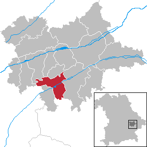
| Location of the community of Marklkofen in the district of Dingolfing-Landau | ||
Marklkofen is a municipality in the Lower Bavarian district of Dingolfing-Landau .
geography
Location and neighboring communities
Marklkofen is located in the Dingolfing region. Marklkofen borders with its location on the south-western edge of the district boundaries as well as the districts of Rottal-Inn and Landshut. The neighboring communities include:
- Dingolfing in the north-west
- Gottfrieding in the north
- Frontenhausen in the south-west
- Reisbach in the east and in the north
- Loiching in the west
- Gangkofen in the south
- Aham in the south-west
Parish parts
The municipality has 51 officially named parts of the municipality: The main town of Marklkofen is a parish village next to Steinberg and belongs to it as well as the church villages Aiglkofen , Aunkofen , Poxau and Ulrichschwimmbach as well as the villages Birnthal, Freinberg, Warth, Weinberg and Wunder. But the hamlets of Aigen, Bogen, Gindlkofen, Grietzen, Gschaid, Hub, Johannisschwimmbach, Kay, Klosbach, Lauterbach, Mülleröd, Roßhof, Stockhof, Weiher and Ziegelstadl are also part of the municipality, as are the deserted areas ( individual settlements ) Aichberg, Berngern, Eckschneid , Einaugmühle, Ernsthof, Fellerhof, Göttersberg, Grub, Gruberhof, Hackl, Hansöd, Heimlichschönau, Holzhäusl, Leiten, Liebertsöd, Petzenbrunn, Pflanzenöd, Reithen, Rosenmühl, Rußhäusl, Schwingham, Senetsberg, Siglhof, Straßwimm and Wildenschönau.
Markings
There are the districts of Marklkofen, Poxau, Steinberg, Frauenbiburg and Reith.
history

Marklkofen belonged to the barons of Pfetten and the barons of Imsland. The place was part of the Electorate of Bavaria and included two closed court brands, the seat of which was the respective castle (middle / purlins, lower / Imsland). The barons of Fraunhofen were also owners until 1857. Through a donation from the head of the house at the time, the castle and property were given to the poor school sisters v. U. L. Fr. with the condition that a school should also be established therein. Until recently, 40 internal and 30 external students had been taught. In November 2006 the donation fell back to Count Christoph von Soden-Fraunhofen in Neufraunhofen, because the business, most recently a vocational school for child care, could no longer be maintained by the poor school sisters and the diocese of Regensburg could not join the foundation.
On October 15, 1875, Marklkofen was connected to the railway network when the Mühldorf – Pilsting railway line opened. However, the connection north of Marklkofen has been closed since 1969, while the southern section has only been used for freight traffic since September 27, 1970.
Incorporations
| Former parish |
Area ha |
Residents (1970) |
date | annotation |
|---|---|---|---|---|
| Frauenbiburg | 620.91 | 150 | 01/01/1972 | Incorporation of 150 of the 925 residents, reclassification of the other residents to Dingolfing; On July 1, 1979, the districts of Achatzstall and Neuhausen with 30 residents were reclassified to Dingolfing |
| Poxau | 957.79 | 654 | 04/01/1971 | |
| Reith | 357.55 | 95 | 04/01/1971 | Incorporation of 95 of the 522 inhabitants (districts Aunkofen, Hackl, Weiher and the Höfertsmühle, which was relocated because of the Vilstalsee ), the other inhabitants were reclassified to Reisbach |
| Steinberg | 651.64 | 815 | 04/01/1971 |
Population development
In the period from 1988 to 2018, the municipality grew from 3,443 to 3,737 by 294 inhabitants or 8.5%.
- 1961: 2669 inhabitants
- 1970: 2952 inhabitants
- 1987: 3358 inhabitants
- 1991: 3624 inhabitants
- 1995: 3707 inhabitants
- 2000: 3732 inhabitants
- 2005: 3703 inhabitants
- 2010: 3659 inhabitants
- 2015: 3681 inhabitants
politics
mayor
The mayor of the community has been Peter Eisgruber-Rauscher (CSU) since May 2014; it was confirmed on March 15, 2020 with 87.5% of the vote for a further six years.
Municipal council
The election on March 15, 2020 resulted in the following distribution of mandates in the municipal council (without 1st mayor):
- CSU : 5
- Free voters : 4
- SPD : 1
- Marklkofen women's list : 2
- CWG Poxau: 2
- Young Citizens List: 2
The turnout was 60.5%.
coat of arms
Blazon : a widened silver bar in black, covered with the word “dear” in red Gothic lowercase letters.
Town twinning
-
 Poland : Since May 10, 2001 there has been a partnership with the Sniadowo municipality from the Podlaskie Voivodeship ( Województwo podlaskie in Polish ).
Culture and sights
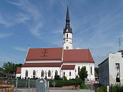
The parish church of the Assumption of Mary is a stately three-aisled pseudo - basilica of Romanesque origin. It was enlarged in the 15th century to include the St. Anne's Chapel. Inside there are carved figures from the 16th century and a sandstone relief Lamentation of Christ from 1520. Also noteworthy are several tombs from the 15th and 16th centuries, including the monument to Wilhelm Zachreis († 1423) and a red marble slab for the brothers of Fraunberg (1555–60) and an epitaph for Johann von Fraunberg († 1597).
Architectural monuments
Economy and Infrastructure
Economy including agriculture and forestry
The second largest employer in the district of Dingolfing-Landau, the automotive supplier Mann + Hummel GmbH, which also has plants in Sonneberg, Speyer, Ludwigsburg and other locations, is located there. The GIMA brickworks ( Gi rnghuber GmbH Ma rklkofen) should also be mentioned.
According to official statistics, there were eight employees at the place of work in the field of agriculture and forestry, 2330 in the manufacturing sector and 26 in the trade and transport sector. In other economic sectors, 98 people were employed at the place of work subject to social security contributions. There were a total of 1409 employees at the place of residence subject to social security contributions. There were four companies in the manufacturing sector and five in the construction sector. In addition, in 1999 there were 94 farms with an agriculturally used area of 2515 ha, of which 2118 ha were arable land and 388 ha were permanent green space. There is also a sawmill with a planer. This sells, among other things, bark mulch to everyone.
traffic
Frontenhausen-Marklkofen is on the Mühldorf – Pilsting railway line . In the direction of Mühldorf (Oberbay) it is only used for freight traffic; in the direction of Pilsting it is shut down.
education
The following institutions existed in 2015:
- Day care center with 222 kindergarten places and 213 supervised children
- Elementary and middle / secondary school with 16 teachers and 284 children taught.
Personalities
- Michael Jahrstorfer (1896–1972), German chemist and manager at BASF
- Peter Högl (1897–1945), SS-Obersturmführer and criminal director of the Reich Security Service
- Martin Sperr (1944–2002), Lower Bavarian playwright and actor
Individual evidence
- ↑ "Data 2" sheet, Statistical Report A1200C 202041 Population of the municipalities, districts and administrative districts 1st quarter 2020 (population based on the 2011 census) ( help ).
- ↑ Geographical location - Marklkofen municipality. Retrieved February 12, 2019 .
- ^ Community homepage , accessed on June 6, 2020.
- ^ The coat of arms of the community of Marklkofen. Marklkofen municipality, accessed on June 21, 2020 .
- ^ Partnership with the Polish community of Sniadowo. Marklkofen municipality, accessed on June 21, 2020 .
Web links
- Entry on the coat of arms of Marklkofen in the database of the House of Bavarian History
- Marklkofen: Official statistics of the LfStat (PDF; 1.66 MB)


