Wallersdorf
| coat of arms | Germany map | |
|---|---|---|
|
Coordinates: 48 ° 44 ' N , 12 ° 45' E |
|
| Basic data | ||
| State : | Bavaria | |
| Administrative region : | Lower Bavaria | |
| County : | Dingolfing-Landau | |
| Height : | 334 m above sea level NHN | |
| Area : | 71.17 km 2 | |
| Residents: | 7013 (Dec. 31, 2019) | |
| Population density : | 99 inhabitants per km 2 | |
| Postal code : | 94522 | |
| Area code : | 09933 | |
| License plate : | DGF, LAN | |
| Community key : | 09 2 79 137 | |
| LOCODE : | DE WEO | |
| Market structure: | 17 districts | |
Market administration address : |
Marktplatz 19 94522 Wallersdorf |
|
| Website : | ||
| Mayor : | Franz Aster (community of committed citizens) | |
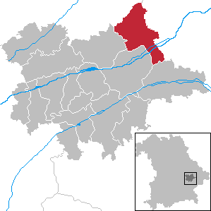
| Location of the Wallersdorf market in the Dingolfing-Landau district | ||
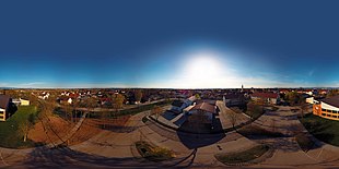
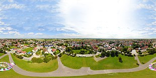
Show as spherical panorama
Wallersdorf is a market in the Lower Bavarian district of Dingolfing-Landau .
geography
location
Wallersdorf is in the Landshut region and on the southern edge of the Gäuboden .
Markings
The following districts exist : Altenbuch , Haidenkofen , Haidlfing , Wallersdorf, Ettling .
Parish parts
Wallersdorf forms the main town , parish villages are Altenbuch, Ettling and Haidlfing. Moosfürth is a church village . The villages of the Wallendorf market include Haidenkofen, Mattenkofen, See, Wallersdorfermoos and Westerndorf. The area also includes the hamlets of Ettlingermoos, Haidlfingermoos, Karlshof, Meisternthal, Vierhöfen and Wolfersdorf and the wasteland of Lindhof.
history
Until the 19th century
For the first time the place was mentioned in writing in 741 as Walhinesdorf . In the 12th century Wallersdorf was a Hofmark under aristocratic administration, jurisdiction was incumbent on the sovereign. The place belonged to the regional court Natternberg . The first parish school was built in 1613, and new schoolhouses were built in 1792 and 1860.
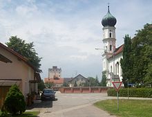
On September 20, 1849, the church and several houses burned down. The new church was consecrated in 1859.
20th and 21st centuries
On January 1, 1902, part of the municipality was spun off and the new municipality of Lailling was formed from it.
After the end of the Second World War , a concentration camp cemetery was laid out on the road to Ganacker, where at least 149 Jewish victims of forced labor from the Ganacker satellite camp were buried. These prisoners had to carry out digging and repair work at the air base there under miserable conditions. Two gravestones commemorate the dead, who were later exhumed and partly transferred to their Belgian homeland and partly buried in the Flossenbürg concentration camp cemetery.
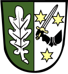
In 1953 Wallersdorf was elevated to market status and in 1954 received a coat of arms.
Incorporations
In the course of the major regional reform, Wallersdorf was significantly enlarged on January 1, 1972. The previously independent communities Haidlfing and Haidenkofen were incorporated. On May 1, 1978, the community of Altenbuch and parts of the dissolved community of Ettling joined.
Population development
In the period from 1988 to 2018, the market grew from 5,614 to 7,011 by 1,397 inhabitants or 24.9%.
- 1961: 5604 inhabitants
- 1970: 5378 inhabitants
- 1987: 5646 inhabitants
- 1991: 5887 inhabitants
- 1995: 6460 inhabitants
- 2000: 6597 inhabitants
- 2005: 6758 inhabitants
- 2010: 6739 inhabitants
- 2015: 6799 inhabitants
- 2018: 7011 inhabitants
politics
Franz Aster (community of committed citizens) has been the first mayor since May 2020. In the runoff election for the local elections in Bavaria 2020 , he prevailed on March 29, 2020 with 56.8 percent against Gudrun Zollner (CSU).
Ottmar Hirschbichler (CSU) was first mayor from May 2008 to April 2020.
Architectural monuments
Economy and Infrastructure
Economy including agriculture and forestry
According to official statistics, there were 48 employees at the place of work in 1998 in the field of agriculture and forestry, 386 in the manufacturing sector and 292 in trade and transport. In other economic sectors, 218 people were employed at the place of work subject to social security contributions. There were a total of 2278 employees at the place of residence subject to social insurance contributions. There was one company in the manufacturing sector and five companies in the main construction sector. In addition, in 1999 there were 217 farms with an agricultural area of 5923 hectares, of which 5568 hectares were arable land and 346 hectares were permanent green space.
The Isar power station of the same name is located in the Ettling district .
Established businesses
- BMW Group , parts warehouse Wallersdorf plant 02.92
- Lung Lufttechnische Anlagen GmbH (centrifugal fans and extraction systems)
- Josef Hochleitner KG (bedding factory)
- Schöfer Schlosserei GmbH (metal processing)
traffic
Wallersdorf has a train station on route 931 (Munich–) Landshut – Plattling (–Passau) and two motorway exits on the A 92, as well as a bus station at the Volksfestplatz in the heart of the community. Between 1926 and the end of 1949, a narrow-gauge railway , the Wallersdorf – Münchshöfen small railway, ran between Wallersdorf and Münchshöfen to supply the rural area.
education
In 2018 there were the following institutions:
- Two day-care centers with 192 places
- Bischof Riccabona Primary School Wallersdorf: 202 pupils and ten full-time teachers (as of 2017/2018)
- Bischof-Riccabona-Mittelschule Wallersdorf: 72 students and seven full-time teachers (as of 2017/2018)
Personalities
- Karl Joseph von Riccabona (* 1761; † 1839), pastor in Wallersdorf (1790–1821), Bishop of Passau (from 1826); the heraldic right half of the municipal coat of arms is taken from the coat of arms of Riccabona
- Georg Kraus (* 1938), Roman Catholic theologian
- Gerd Gigerenzer (* 1947), psychologist
- Bernhard R. Appel (* 1950), musicologist
Web links
- Entry on Wallersdorf's coat of arms in the database of the House of Bavarian History
- Wallersdorf: Official statistics of the LfStat (PDF; 1.66 MB)
- Markt Wallersdorf in the location database of the Bayerische Landesbibliothek Online . Bavarian State Library
Individual evidence
- ↑ "Data 2" sheet, Statistical Report A1200C 202041 Population of the municipalities, districts and administrative districts 1st quarter 2020 (population based on the 2011 census) ( help ).
- ↑ http://www.wahlen.bayern.de/biz/kowa_g2008.php?g=h&schluessel=279&suchbegriff=2
- ↑ a b Wilhelm Volkert (Ed.): Handbook of the Bavarian offices, communities and courts 1799–1980 . CH Beck, Munich 1983, ISBN 3-406-09669-7 , p. 505 .
- ↑ Memorial sites for the victims of National Socialism. A documentation, volume 1. Federal Agency for Civic Education, Bonn 1995, ISBN 3-89331-208-0 , p. 197
- ^ Federal Statistical Office (ed.): Historical municipality directory for the Federal Republic of Germany. Name, border and key number changes for municipalities, counties and administrative districts from May 27, 1970 to December 31, 1982 . W. Kohlhammer GmbH, Stuttgart / Mainz 1983, ISBN 3-17-003263-1 , p. 634 .
- ↑ The run-off elections on Sunday, 29 March 2020. In: Wahl.info. March 30, 2020, accessed March 30, 2020 .
- ↑ Bischof-Riccabona-Grundschule Wallersdorf in the school database of the Bavarian State Ministry for Education and Culture , accessed on May 24, 2019.
- ↑ Bischof-Riccabona-Mittelschule Wallersdorf in the school database of the Bavarian State Ministry for Education and Culture , accessed on May 24, 2019.

