Mamming
| coat of arms | Germany map | |
|---|---|---|

|
Coordinates: 48 ° 39 ' N , 12 ° 36' E |
|
| Basic data | ||
| State : | Bavaria | |
| Administrative region : | Lower Bavaria | |
| County : | Dingolfing-Landau | |
| Management Community : | Mamming | |
| Height : | 368 m above sea level NHN | |
| Area : | 41.48 km 2 | |
| Residents: | 3232 (Dec. 31, 2019) | |
| Population density : | 78 inhabitants per km 2 | |
| Postal code : | 94437 | |
| Area code : | 09955 | |
| License plate : | DGF, LAN | |
| Community key : | 09 2 79 125 | |
| LOCODE : | DE MMI | |
| Address of the municipal administration: |
Main street 15 94437 Mamming |
|
| Website : | ||
| Mayoress : | Irmgard Eberl ( CSU ) | |
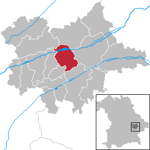
| Location of the community of Mamming in the district of Dingolfing-Landau | ||
Mamming is a municipality in the Lower Bavarian district of Dingolfing-Landau and the seat of the Mamming administrative community .
geography
Parish parts
The community has 22 districts :
|
|
|
history
Until the church is planted
The establishment of the place Mamming belongs to the settlements of the early period, to the long row of "Ing-places" on the right bank of the Isar. These place names with the ending "-ing" indicate a foundation in the 5th / 6th. Century. In addition to the Ing-places, the many -haus and -ham, the -hofen and -kofen-places, especially around Mamming, appeared in the 8th century, which expanded the new settlement area. These places also belong to the early days without documents.
The first mention is in the year 1011, when King Heinrich II. Donated his chamber goods in "Mammingun" to the diocese of Bamberg, which he founded. Mamming later belonged to the Landshut Rent Office and the Dingolfing Regional Court of the Electorate of Bavaria . In the course of the administrative reforms in Bavaria , the municipality was created with the municipal edict of 1818 .
19th and 20th centuries
With the opening of the Mühldorf – Pilsting (–Plattling) railway , Mamming was connected to the railway network on October 15, 1875. In the district of Mammingerschwaigen, a station was also built in 1880 on the Landshut – Plattling railway line . While the Mammingen station was abandoned when the line was closed in 1969, the Schwaigen station still exists, but is not used for tourist traffic.
In April 1945, the Isar crossing at Mamming was defended by SS troops against the advancing Americans . This resulted in a one-day battle, during which several local residents and the village pastor lost their lives. The late Gothic parish church, the Isar bridge and forty properties were destroyed by artillery fire .
Incorporations
As part of the regional reform on January 1, 1972, the municipality of Bubach (with the places Bubach, Berg, Dittenkofen, Ruhsam, Attenberg, Schneiderberg, Adlkofen, Kuttenkofen, Vollnbach, Hirnkofen and Graflkofen) was incorporated.
Population development
In the period from 1988 to 2018, the municipality grew from 2,347 to 3,238 by 891 inhabitants or 38%.
- 1961: 2112 inhabitants
- 1970: 2182 inhabitants
- 1987: 2309 inhabitants
- 1991: 2430 inhabitants
- 1995: 2654 inhabitants
- 2000: 2794 inhabitants
- 2005: 3067 inhabitants
- 2010: 2891 inhabitants
- 2015: 3109 inhabitants
politics
mayor
The first mayor is Irmgard Eberl (CSU). She has been in office since May 1, 2020. Her predecessor since May 1984 was Georg Eberl (CSU). He was last re-elected in March 2014 with 86.4% of the vote.
Municipal council
The municipal council elected for the years 2020 to 2026 consists of the First Mayor and 16 members:
| 6th | Members of the CSU |
| 3 | Members of the Free Voters |
| 1 | Member of the SPD |
| 2 | Members of the UWG |
| 1 | Member of the JU |
| 3 | Members of the WGM |
coat of arms
Blazon : divided by a mountain of three of silver and black; above a curled, overturned red tip, below a silver rose
The important Regensburg councilor dynasty, the "Mämminger", came from Mamming. Your family coat of arms, the rose, is now part of the Mammingen municipal coat of arms. The Mämmingers often called themselves "Memmingen" or "von Memmingen" in order to pretend that they came from the important imperial city of Memmingen instead of coming from the Lower Bavarian village .
Culture and sights
Buildings
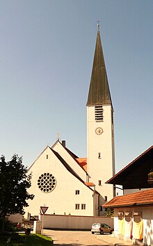
The parish church of St. Margareta , which with its 55 meter high tower characterizes the townscape of Mamming, is the successor to a late Gothic church that was destroyed in the Second World War. It was built between 1947 and 1949 according to plans by Friedrich Ferdinand Haindl and furnished by Josef Henselmann and his students.
Natural monuments and geotopes
- Alluvial fan Rosenau, postglacial Danube / Main gravel (Holocene), geotope number 279R006, an area around 150 m long and 100 m wide around 2 km northwest of the center of Mamming
- Source at Schellmühle, layer source, geotope number 279Q001, area accessible, protected natural monument
- Mamminger Bach Valley, asymmetrical Sohlental, geotope number 279R002, an area around 1500 m long and 400 m wide southwest of the center of Mamming
Economy and Infrastructure
In 1998, according to official statistics, there were 301 employees at the place of work in the manufacturing sector and 56 in trade and transport. In other economic sectors this figure was 86 people. There were 1040 employees subject to social security contributions at the place of residence. There were two companies in the manufacturing sector and five in the construction sector.
- Mamminger canning factory
Agriculture and Forestry
In 1998 there were eleven employees subject to social security contributions in the field of agriculture and forestry. In addition, there were 102 agricultural holdings in 1999 with an agriculturally used area of 2461 ha, of which 2250 ha were arable land and 210 ha were permanent green space.
traffic
Mamming station was on the Mühldorf – Pilsting railway line , which has since been closed in this section.
education
In 1999 the following institutions existed:
- Kindergartens: 69 kindergarten places with 89 children
- Elementary schools: one with 28 teachers and 407 students
Sons and daughters of the place
- Franz Kober (* 1956), engineer (cinema)
- Helmfried Kober (* 1965), cameraman
- Werner Bumeder (* 1967), German politician ( CSU ) and District Administrator Dingolfing-Landau
Individual evidence
- ↑ "Data 2" sheet, Statistical Report A1200C 202041 Population of the municipalities, districts and administrative districts 1st quarter 2020 (population based on the 2011 census) ( help ).
- ^ Mamming community in the local database of the Bavarian State Library Online . Bavarian State Library, accessed on April 28, 2018.
- ^ Wilhelm Volkert (ed.): Handbook of Bavarian offices, communities and courts 1799–1980 . CH Beck, Munich 1983, ISBN 3-406-09669-7 , p. 447 .
- ↑ https://www.wahlen.bayern.de/kommunalwahlen/
Web links
- Entry on Mamming's coat of arms in the database of the House of Bavarian History
- St. Margareta Church, Mamming
- Mamming: Official statistics of the LfStat (PDF; 1.66 MB)


