Moosthenning
| coat of arms | Germany map | |
|---|---|---|

|
Coordinates: 48 ° 41 ′ N , 12 ° 30 ′ E |
|
| Basic data | ||
| State : | Bavaria | |
| Administrative region : | Lower Bavaria | |
| County : | Dingolfing-Landau | |
| Height : | 368 m above sea level NHN | |
| Area : | 70.43 km 2 | |
| Residents: | 4921 (Dec. 31, 2019) | |
| Population density : | 70 inhabitants per km 2 | |
| Postal code : | 84164 | |
| Area code : | 08731 | |
| License plate : | DGF, LAN | |
| Community key : | 09 2 79 128 | |
| LOCODE : | DE OOH | |
| Community structure: | 6 municipalities 57 parts of the municipality |
|
| Address of the municipal administration: |
Rathausweg 2 84164 Moosthenning |
|
| Website : | ||
| Mayor : | Anton Kargel (Free Voting Association Thürnthenning) | |
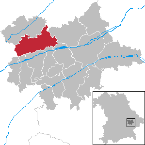
| Location of the municipality of Moosthenning in the district of Dingolfing-Landau | ||
Moosthenning (Bavarian: Moosdenning ) is a municipality in the Lower Bavarian district of Dingolfing-Landau .
geography
location
Moosthenning is located in the Landshut region about 100 km northeast of Munich , not far from the district town of Dingolfing , in the scenic Isar Valley . The Dreifaltigkeitsberg was originally the main triangular network point of the first Bavarian land survey from 1801.
Community structure
The administrative center of the municipality is in the Unterhollerau district. Moosthenning comprises a total of 57 parts of municipalities, including the Pfarr villages Dornwang and Ottering that Kirchdörfer Lengthal , Moosthenning, Rimbach , Thürnthenning and Töding, the villages Forst, gate ring Haid, wood book OBERVIEHLAND Moss, Unterhollerau and Unterholsbach, the Weiler Breitenau, book, librarian Reith, Dreifaltigkeitsberg , Gießübl, Great pond , Habichhorst, small pond, Klosterbergfest, Kronberg, Neukreith, Oberhollerau, Oberschellhart Hart, Rothenbühl, Schöndorf, Seyfriedsheim, Stocker Point, Stopfenreuth, straw mountain, sub clamp Hart, Wolf's field and Zieglstadl as well as the wastes Behrhof, Birket, Postal, Deisenau, Eglhof, Franzberg , Greßlsbach, Haiholz, Hammeröd, Harpoint, Kattenbach, Königsau, Oberdietenau, Oberhaslau, Oberholsbach, Reichenstall, Rothleck, Unterdietenau, Unterhaslau, Unterviehmoos and Winkl.
Markings
The districts, sorted by district and former municipality:
- District Moosthenning: Moosthenning, Burgstall, Reichenstall, Wolfsacker.
- District Dornwang: Dornwang.
- District Lengthal: Breitenau, Buchberg, Buchreith, Deisenau, Eglhof, Forst, Gießübl, Harpoint, Kattenbach, Klosterberg, Kronberg, Lengthal, Oberdietenau, Oberhollerau, Oberholsbach, Oberschellhart, Rothenbühl, Rothleck, Seyfriedsheim, Stopfenreuth, Unterdietenau, Unterdietenau , Sub-shell hard.
- District Ottering: Franzberg, Gattering, Habich, Holzbuch, Königsau, Oberhaslau, Ottering , Stockerpoint, Töding, Unterhaslau, Winkl.
- Rimbach district: Dreifaltigkeitsberg , Neukreith, Rimbach .
- District Thürnthenning: Behrhof, Birket, Greßlsbach, Großweiher , Haid, Haiholz, Hammeröd, Kleinweiher, Oberviehmoos, Schöndorf, Thürnthenning , Unterviehmoos, Zieglstadl.
ecology
The Königsauer Moos and the south-facing slopes of the Isar Valley form important habitats for rare animal and plant species .
history

Moosthenning belonged to the Landshut Rent Office and the Dingolfing Regional Court of the Electorate of Bavaria . The lords of Aythalb and others owned privately owned noble seats here. In 1818, the municipalities of Rimbach, Dornwang, Lengthal, Moosthenning, Thürnthenning and Ottering were created in the implementation of the Second Bavarian municipal edict, which were combined to form the municipality of Moosthenning as part of the regional reform in the 1970s .
In the district of Thürnthenning there was a Hofmark that has been documented since the 14th century. After various changes of ownership, in the 18th century it was subordinate to the lower nobility of the Auer vom Winkel . After a fire in 1732, they built a new castle, which was demolished in 1851. The memory of this building lives on in the house name Schlossbauer . Fragments of the castle are incorporated into the associated, now rural property. The appearance of the castle building has been handed down figuratively, as it is represented in the vault of the Thürnthenning parish church in an ensemble with the church.
Incorporations
The original municipality and the municipalities incorporated directly or indirectly in the course of the regional reform in Bavaria essentially form today's six districts:
|

The former parishes in the northern part of the Dingolfing district
|
Population development
In the period from 1988 to 2018, the municipality grew from 3,756 to 4,917 by 1,161 inhabitants or by 30.9%.
The following figures have been adjusted for the area, i.e. H. older figures (1961 and 1970) have also been converted to the current municipal area:
- 1961: 3318 inhabitants
- 1970: 3259 inhabitants
- 1987: 3736 inhabitants
- 1991: 3880 inhabitants
- 1995: 4132 inhabitants
- 2000: 4392 inhabitants
- 2005: 4673 inhabitants
- 2010: 4765 inhabitants
- 2015: 4903 inhabitants
Attractions

There are two remarkable baroque buildings among the village churches of the community: The pilgrimage church Dreifaltigkeitsberg , built between 1693 and 1714 (tower from 1739, renewed after lightning strike in 1770) and the branch church of St. Johannes Nepomuk in Thürnthenning. The latter was completed by the Dingolfing city architect Georg Weigenthaler in 1732 and decorated with high-quality ceiling frescoes by the Straubing painter Joseph Anton Merz . Due to its location on the northern slopes of the Isar valley, the church impresses with its architectural effect from afar.
In addition, in the districts of Lengthal and Rimbach, some of the log-style farmhouses that were once typical for the region on the eaves side have been preserved in situ , which have withstood the increasing number of demolitions and new buildings in the 1960s and 1970s. In Dornwang (Dorfstrasse 28) there are two stone figures on a house depicting St. Mauritius and St. Florian. They were bought at auction by a local farmer when the baroque high altar of St. John's Church in Dingolfing was demolished in 1884 and re-erected here.
politics
Municipal council
The municipal council includes the 1st mayor and 16 municipal councilors. The election on March 15, 2020 resulted in the following composition for the 2020–2026 term of office:
A total of 16 seats
|
mayor
The first mayor has been Anton Kargel (Free Voting Association Thürnthenning) since May 1, 2020; he won the election on March 15, 2020 against incumbent Markus Baierl with 59.4% of the vote. Kargel's predecessors were:
- Markus Baierl (CSU) from May 1, 2008 to April 30, 2020
- Georg Kutzi (Bürgerliste Lengthal) from May 1, 1996 to April 30, 2008
- Josef Roglmeier (UW) from May 1, 1984 to April 30, 1996
- Otto Altendorfer (CSU) from May 1, 1978 to April 30, 1984
tax income
The municipal tax income amounted to € 3,327,100 in 2009, of which the trade tax income (net) amounted to € 314,600.
coat of arms
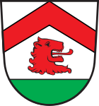
The municipal coat of arms shows a red rafter over a lion's head on a white background . The base of the coat of arms shows the fertile green of the Isar valley. The tinging in silver and red is supposed to be a reference to the Pelkofer family, who had owned Moosthenning since the 14th century. The lion's head comes from the coat of arms of the Auer von Winkl, who were court lords in Ottering and Thürnthenning until the 18th century. The rafter goes back to the coat of arms of the Stinglheimer family, which can be traced back to Thürnthenning from the 13th to the 17th century.
Architectural monuments
Economy and Infrastructure
Economy including agriculture and forestry
According to official statistics, there were 147 employees at the place of work in the manufacturing sector and 89 in the trade and transport sector. There were a total of 1897 employees at the place of residence subject to social security contributions. There was one in the manufacturing industry (more than 20 employees) and seven in the construction industry. In addition, there were 169 farms in 2003 with an agricultural area of 5,106 ha.
In a company belonging to the BMW plant in Dingolfing , bodies for Rolls-Royce are manufactured here.
traffic
The community can be reached via the federal autobahn 92 ( Munich - Deggendorf) from Landshut (34 km), from Deggendorf (48 km), on state roads from Straubing (32 km) and from Eggenfelden (45 km).
education
In 2003/2004 the following institutions existed:
- Kindergartens: 100 kindergarten places with 135 children
- Elementary schools: one with 19 teachers and 331 students
In 2008 the following institutions existed:
- Kindergartens: 140 kindergarten places with 145 children
- Primary and secondary schools: one with 26 teachers and 298 students
societies
The FC Ottering was established in 1948.
Personalities
Joseph Sturm (1888–1962), politician ( Bavarian People's Party )
Web links
- Entry on Moosthenning's coat of arms in the database of the House of Bavarian History
- Wallfahrtskirche am Dreifaltigkeitsberg Pictures from the series Churches of Homeland
- Church of St. Johann Nepomuk in Thürnthenning Pictures from the series Churches of Homeland
- Moosthenning: Official statistics of the LfStat (PDF; 1.66 MB)
Individual evidence
- ↑ "Data 2" sheet, Statistical Report A1200C 202041 Population of the municipalities, districts and administrative districts 1st quarter 2020 (population based on the 2011 census) ( help ).
- ^ Moosthenning community in the local database of the Bayerische Landesbibliothek Online . Bavarian State Library
- ^ A b c Wilhelm Volkert (Ed.): Handbook of the Bavarian offices, municipalities and courts 1799–1980 . CH Beck, Munich 1983, ISBN 3-406-09669-7 , p. 447 .
- ↑ a b Federal Statistical Office (ed.): Historical municipality register for the Federal Republic of Germany. Name, border and key number changes in municipalities, counties and administrative districts from May 27, 1970 to December 31, 1982 . W. Kohlhammer GmbH, Stuttgart / Mainz 1983, ISBN 3-17-003263-1 , p. 634 .
- ↑ distribution of seats according to the municipality's website; this also contains percentages , accessed on June 6, 2020
- ↑ List on the municipality homepage with mayors of the former municipalities from 1948 to 1978 , accessed on June 6, 2020
- ↑ Landkreis Dingolfing-Landau (ed.): Our district - Dingolfing-Landau . 2005, p. 60 .


