
Hackerskofen
|
Hackerskofen
Gottfrieding parish
Coordinates: 48 ° 37 ′ 30 ″ N , 12 ° 33 ′ 24 ″ E
|
|
|---|---|
| Height : | 441 m |
| Area : | 2.33 km² |
| Residents : | 73 (2006) |
| Population density : | 31 inhabitants / km² |
| Incorporation : | January 1, 1946 |
| Postal code : | 84177 |
| Area code : | 08731 |
 Location of the Hackerskofen district, Gottfrieding community, in the Dingolfing district in 1961
|
|
Hackerskofen is a church village in the municipality of Gottfrieding , district of Dingolfing-Landau , left above the valley of the Mamminger Bach, a right side valley of the lower Isar valley . 67 inhabitants live in the village (as of November 2, 2004). In addition to the church village Hackerskofen, the hamlet of Holzhausen also belongs to the former municipality and today's district .
population
Including the population with a second residence , the Kirchdorf Hackerskofen had a population of 61 in 2006, and the hamlet of Holzhausen one of 12 people.
The population development of the municipality, and from 1950 of the former municipality area, took the following course (figures without second homes):
| year | 1840 | 1852 | 1855 | 1861 | 1867 | 1871 | 1875 | 1880 | 1885 | 1990 | 1895 | 1900 | 1905 | 1910 | 1919 | 1925 | 1933 | 1939 | 1950 | 1961 | 1970 | 1987 | 2006 |
| Hackerskofen (village) | ... | ... | ... | ... | ... | ... | 147 | ... | ... | ... | ... | ... | ... | ... | ... | 149 | ... | ... | 140 | 112 | 101 | 92 | ... |
| Holzhausen (hamlet) | ... | ... | ... | ... | ... | ... | 20th | ... | ... | ... | ... | ... | ... | ... | ... | 21st | ... | ... | 23 | 15th | 13 | 9 | ... |
| Hackerskofen (municipality) | 179 | 176 | 162 | 187 | 176 | 167 | 167 | 165 | 156 | 155 | 159 | 157 | 153 | 179 | 174 | 170 | 151 | 139 | 163 | 127 | 114 | 101 | 73 |

history
Hackerskofen was settled in the 6th century when the Bavarians settled in the Isar valley. In the same century the neighboring towns of Holzhausen, Ottenkofen, Frichlkofen and Daibersdorf were founded.
In the Middle Ages , Hackerskofen was a closed Hofmark in the Dingolfing care court with 27 properties. The hamlet of Holzhausen, which was later assigned to the municipality, had a different history; it belonged to the Marklkofen - Thurn region . In a Hackerskofen existed Castle of Stephan von Pelkofen that by 1357 in the war between Louis of Bavaria and the Fair Frederick was destroyed by the Bohemia. In the 15th and 16th centuries the manor house of Hofmark was inhabited again by the Pelkofers. After that, the Goder, the Staudinger, the Egger von Kapfing and the Hochholzer resided there. The castle was destroyed again by the Swedes in 1648. The Burgstall was still visible in the 19th century. Today only Schloßstraße, in which the former village inn (most recently Gasthaus Brandmaier) is located, bears witness to this castle. A chapel was built in 1733 on the site of today's side church in Seven Sorrows . The current church was built around 1800 and changed in a modern Gothic style in 1856.
In Joseph of Hazzis statistical breakdown of the duchy of Bavaria from 1808 is Hackerskofen as Hofmark within the chairman shaft Pilberskofen and Grißbach ( Griesbach listed) with 24 houses and as many hearths. Holzhausen (two houses, two hearths) was then part of the Günz and Fruchtchlkofen ( Frichlkofen ) committee.
On January 1, 1946, the formerly independent community with its two districts was incorporated into the Gottfrieding community by order of the local office of the US military government. Until then, Hackerskofen was the smallest municipality after the population and the second smallest municipality after the area of the then district of Dingolfing (only the Reisbach market had a smaller area within its former borders). Hackerskofen was the first and only municipality of originally 33 municipalities in the former Dingolfing district that was dissolved before the regional reform in Bavaria .
Appearance
The townscape is characterized by the tower of the Catholic branch church St. Maria, which was built around 1800 and received its current neo-Gothic appearance in 1856 during a renovation . In addition, this looks Bavarian State Conservation Office 5 more houses in Hackerskofen to be maintained, as well as a chapel - shrine on the road from Anterskofen after Hackerskofen.
Picture gallery

Hackerskofen from the south

Church of the Seven Sorrows of Mary from the southeast

Church inside
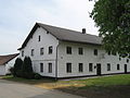
Former village inn, Gasthaus Brandmaier

Hamlet Holzhausen from the north

Chapel shrine on the road from Hackerskofen to Holzhausen

Holzerkapelle southwest of Holzhausen

Holzerkapelle close-up


Individual evidence
- ↑ Gottfrieding parish on the Internet
- ↑ Bavarian State Statistical Office (Hrsg.): Historical municipality register: The population of the municipalities of Bavaria in the period from 1840 to 1952 (= contributions to Statistics Bavaria . Issue 192). Munich 1954, DNB 451478568 , p. 54 , urn : nbn: de: bvb: 12-bsb00066439-3 ( digitized version ).
- ^ Homepage of Gottfrieding
- ↑ Review files for the court investment books of the court brands in the Dingolfing nursing court ( memento of the original dated February 16, 2018 in the Internet Archive ) Info: The archive link was inserted automatically and has not yet been checked. Please check the original and archive link according to the instructions and then remove this notice.
- ↑ Bernd Stadlbauer: The Altland District Dingolfing. = Historical Atlas of Bavaria / Part of Old Bavaria. Series I, Volume 65, Munich 2015, ISBN 978-3-7696-6557-4 , p. 324
- ↑ Bernd Stadlbauer: The Altland District Dingolfing. = Historical Atlas of Bavaria / Part of Old Bavaria. Series I, Volume 65, Munich 2015, ISBN 978-3-7696-6557-4 , p. 341
- ^ Joseph Wolfgang Eberl: History of the city of Dingolfing and its surroundings, Dingolfing 1856
- ↑ The art monuments of Bavaria. District Office Dingolfing. Munich 1912, page 60
- ↑ Joseph von Hazzi: Statistical information about the Duchy of Baiern, drawn from genuine sources. A general contribution to the country u. Human studies. Fourth volume. Nuremberg 1808 , pp. 230-232
- ^ Wilhelm Volkert (ed.): Handbook of Bavarian offices, communities and courts 1799–1980 . CH Beck, Munich 1983, ISBN 3-406-09669-7 , p. 447 .
- ↑ Bavarian State Office for Monument Preservation: Gottfrieding, Baudenkmäler (PDF; 136 kB)
Web links
- Hackerskofen in the location database of the Bayerische Landesbibliothek Online . Bavarian State Library