Frichlkofen
|
Frichlkofen
Gottfrieding parish
Coordinates: 48 ° 37 ′ 12 ″ N , 12 ° 31 ′ 33 ″ E
|
|
|---|---|
| Height : | 389 m above sea level NN |
| Residents : | 194 (Nov. 2, 2004) |
| Incorporation : | 1824 |
| Postal code : | 87177 |
| Area code : | 08731 |
|
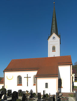
St. Laurentius Church seen from the west
|
|
Frichlkofen is a church village and part of the Lower Bavarian municipality of Gottfrieding in the Dingolfing-Landau district .
Location and inhabitants
It is located in the Weilnbachtal , a right side valley of the lower Isar valley , through which the Gottfriedinger Bach flows, which also flows through the village, 1,100 meters below Unterweilnbach and 1,200 meters above the village of Gottfrieding. 194 inhabitants live in the village (as of November 2, 2004). According to the community register of Gottfrieding, Frichlkofen had 198 residents in their main and secondary residence on July 1, 2013.
history
Frichlkofen was settled in the 6th century when the Bavarians settled in the Isar valley. During the Thirty Years War , a cannon station for the Schwedenschanze in Oberdingolfing was built on the Schusterberg . In 2012 Frichlkofen celebrated its millennium. Frichlkofen was first mentioned in a document in 1011: At the request of his wife Kunigunde of Luxembourg , King Heinrich II gave Frochilinchouun to the then Bishop Eberhard von Bamberg and his successors.
According to Joseph von Hazzi's statistics on the Duchy of Baiern from 1808, Fruchtchelkofen, with 25 houses and just as many stoves, belonged to the Günz and Fruchtchlkofen presidency .
In the course of the administrative reforms in Bavaria , the municipality of Frichlkofen was created with the municipal edict of 1818 , which also included the districts of Golding , Tichling , Unterweilnbach , Reitholz , Kaltenberg and Hacklberg , which was not mentioned at the time . In 1823/24 the municipality of Frichlkofen was incorporated into the municipality of Gottfrieding, with the exception of Kaltenberg (after Frauenbiburg ) and Reitholz (after Griesbach ).
Monuments
The townscape is characterized by the tower of the Catholic branch church St. Laurentius. The building was built in the 12th century in the Romanesque style and later remodeled in the early Gothic and Baroque styles. A farmhouse and a barn are also under monument protection.
Individual evidence
- ↑ Gottfrieding: residents ( Memento of the original from October 21, 2013 in the Internet Archive ) Info: The archive link was automatically inserted and not yet checked. Please check the original and archive link according to the instructions and then remove this notice.
- ↑ Gottfrieding: Historical: 1000 years of Frichlkofen
- ↑ 1000 year celebration in Frichlkofen ( page no longer available , search in web archives ) Info: The link was automatically marked as defective. Please check the link according to the instructions and then remove this notice.
- ↑ Joseph von Hazzi: Statistical information about the Duchy of Baiern, drawn from genuine sources. A general contribution to the country u. Human studies. Fourth volume. Nuremberg 1808, p. 230
- ↑ Joseph von Hazzi: Statistical information about the Duchy of Baiern, drawn from genuine sources. A general contribution to the country u. Human studies. Fourth volume. Nuremberg 1808, p. 384
literature
- Paulstreifeder: Frichlkofen, from its thousand-year history. Wälischmiller, Dingolfing 2012
Web links
- Frichlkofen in the location database of the Bavarian State Library Online . Bavarian State Library

