
Teisbach
|
Teisbach
City of Dingolfing
|
|
|---|---|
 |
|
| Height : | 383 m |
| Area : | 9.15 km² |
| Residents : | 1666 (Jun 30, 2010) |
| Population density : | 182 inhabitants / km² |
| Incorporation : | January 1, 1972 |
| Postal code : | 84130 |
| Area code : | 08731 |
 Location of the Teisbach market in what was then the district of Dingolfing in 1961
|
|
Teisbach is an officially named part of the municipality of Dingolfing and a district in the western district of Dingolfing-Landau . The place name Teisbach is derived from the body of the same name .
In the course of the regional reform in Bavaria , the former market Teisbach and thus also the main town came to the city of Dingolfing in 1972 . The Teisbach district extends from the right Isar high bank into the Isar valley to the Schwarzgraben in the Isarmoos on the left of the Isar and north of the BAB 92 .
geography

At the time of its dissolution, the Teisbach market bordered the town of Dingolfing (east) and the communities of Frauenbiburg (south-east), Weigendorf (south), Loiching (west), Dornwang (north) and Lengthal (north-east) of what was then the district of Dingolfing .
In addition to the town of Teisbach on the right of the Isar, the former seat of the municipality, the community included three further districts in the Isar valley on the left of the Isar, the closely neighboring villages of Höfen , Schönbühl and the hamlet of Gaubitzhausen . Of the municipal area of 915 hectares, 303 hectares were allocated to the area to the right of the Isar (Teisbach) and 612 hectares to the area to the left of the Isar (Höfen, Schönbühl and Gaubitzhausen with surrounding corridors). For districts that used to belong to the municipality, a total population of 1483 was determined on the occasion of the 1987 census (Teisbach 966, Höfen 385, Schönbühl 111 and Gaubitzhausen 21). As of June 30, 2011, the city of Dingolfing reported a population with main residence from 1666 from the register of residents (Teisbach 1138, Höfen 390, Schönbühl 121 and Gaubitzhausen 17).
In the eastern valley floor, the eponymous Teisbach, which originates south of Oberteisbach , flows north to the Isar. The hamlet of Oberteisbach did not belong, as one might assume from its name, to the Teisbach market, but to the southern neighboring community of Weigendorf, which was incorporated into Loiching in 1978. Oberteisbach, however, belongs to the Teisbach parish .
Population development
The population development of the former Teisbach market is shown in the following table:
The figures up to 1970 correspond to the Teisbach market and are not adjusted for area status; the population increase of 595 (74 percent) between 1939 and 1946 is therefore also due to the incorporation of the Loichinger districts Höfen (Loichinger Teil), Schönbühl and Gaubitzhausen on January 1, 1946. From 1970 the numbers correspond to the sum of the Dingolfing districts of Gaubitzhausen, Höfen, Schönbühl and Teisbach
| year | 1840 | 1852 | 1855 | 1861 | 1867 | 1871 | 1875 | 1880 | 1885 | 1890 | 1895 | 1900 | 1905 | 1910 | 1919 | 1925 | 1933 | 1939 | 1946 | 1950 | 1952 | 1961 | 1970 | 1987 | 2010 | 2018 |
|---|---|---|---|---|---|---|---|---|---|---|---|---|---|---|---|---|---|---|---|---|---|---|---|---|---|---|
| population | 579 | 663 | 632 | 717 | 761 | 764 | 781 | 826 | 870 | 882 | 782 | 706 | 738 | 848 | 894 | 907 | 896 | 824 | 1419 | 1460 | 1390 | 1309 | 1354 | 1483 | 1666 | 2068 |

traffic
The north-south running district road DGF 16 leads over the Isar and connects the market Teisbach with the districts Schönbühl and Höfen. To the north it crosses Industriestrasse, where it forms the western boundary of the BMW Dynamic Center, and continued on the A 92 to Dornwang until December 2014 . In the south, the DGF-16 takes you to Oberteisbach .
The east-west running state road 2074 crosses in Höfen (until the completion of the A 92 in 1988 it was federal road 11 , which was downgraded to a state road in this area). The DGF 1 district road running through the market town leads to Loiching in the west and Dingolfing in the east.
The A 92 runs along the northern border of the former municipal area. At the BMW Dynamic Center, where the DGF 16 runs over the A 92, the third motorway junction in the city of Dingolfing and the first in the former municipality were opened to traffic on December 9, 2014. The DGF 16 had already been dismantled to the north towards Dornwang or relocated around 1500 meters to the east over the roundabout at Grüblhof. The level crossing in Höfen is already closed and will be removed.
The former municipal area is served by one of the four urban bus routes ("Dingo") within the scope of local public transport . The “red dingo” runs every hour via the Dingolfing district of Krautau to the districts of Teisbach, Höfen, Schönbühl and Gaubitzhausen.
The BMW Dynamic Center has its own siding (see below).
history
The establishment of the place Teisbach is presumed for the end of the eighth century. Around 1180 a castle was built in Teisbach, which served as the seat of the Counts of Frontenhausen . When Count Konrad , the last of his line, was elected Bishop of Regensburg in 1204 , he bequeathed half of his inheritance, including Dingolfing (at that time only the Lower City) and Teisbach to the bishopric. In 1251, Teisbach Castle, which belonged to the Bishop of Regensburg, was conquered and razed by Duke Ludwig II . The stones were used to found the Upper City of Dingolfing, which, as a ducal city, was to be enthroned above the already existing episcopal settlement (today's Lower City of Dingolfing around today's St. John 's Church ). From 1251 the stream of the same name is mentioned as the border between the newly founded town of Dingolfing and the Teisbach rulership, and from 1386 as the border between the Dingolfing and Teisbach regional courts. After the establishment of the Teisbach regional court (the old regional courts were the forerunners of today's districts ), the Teisbach market was of regional importance for the area between Landshut and Dingolfing south of the Isar for almost four centuries , until it was transferred to the Bavarian regional courts as part of the reorganization of the regional courts in Bavaria Vilsbiburg district court fell. The ducal Bavarian market privilege was not officially granted to Teisbach until 1533, although the place had been the seat of the nursing court for almost 250 years at that time. 1838 Teisbach came to a rebuilt district court Dingolfing, the district office was Dingolfing from the territory in 1962, the 1935 district Dingolfing said.
As of 1752, the Teisbach Regional Court included six offices (Teisbach, Pilsting, Frontenhausen, Kirchberg, Adlkofen and Ergoldsbach) with a total of 24 chairmen , at that time the administrative units of the lowest level. The Teisbach office consisted of the Dornwang, Höfen in Schwaigen, Weigendorf and Loiching chairmen. The chairmanship of Höfen in Schwaigen is the village of Höfen with 12 properties, which was added to the new municipality of Loiching when the municipalities were established by the municipal edict 1808/18, including Schönbühl ( Schönbichlmühle ) and Grüblhof ( inn at Grieblhof ), not to the left of the Isar part of the Teisbach market, which was also called Höfen and was listed as a hamlet with four properties in 1752. The Teisbacher hamlet Höfen was located immediately west of the Obmannschaft Höfen in Schwaigen, the village that was defeated during the formation of the community in Loiching. It was spatially separated from the main area of the market on the right of the Isar and thus represented a 170-hectare exclave , which can still be proven on a municipal boundary map from 1941.
In the topographical-statistical manual for the Isar district in the Kingdom of Baiern from 1825, Teisbach is listed with 414 inhabitants in 106 houses. The Höfen exclave belonging to the Teisbach market would have to be subsumed under it, as it is not listed separately (within the Vilsbiburg Regional Court, only the Höfen belonging to the Loiching municipality is listed).
It was not until January 1, 1946 that the community of Loiching had to cede to Markt Teisbach by order of the American military government Höfen, Schönbühl and Gaubitzhausen (essentially the former chairmanship of Höfen in Schwaigen , but without the Grüblhof, which was given to the city of Dingolfing). As a result, the municipality of Teisbach was rounded off . On the same occasion, the Grüblhof was added to the city of Dingolfing. Since then there has only been one farm. Although many of the municipal area changes made by the American military government in Bavaria between 1947 and 1949 were reversed by the Bavarian Ministry of the Interior, the incorporation of these places into Markt Teisbach was retained out of an urgent public interest (among other things because of school and church affiliation). The Loichingen districts of Oberteisbach , Maßendorf, Piegendorf and Goben, south of Teisbach, also belonged to Teisbach in terms of school and church, but the operation of their incorporation by Teisbach was not crowned with success, especially because of the overwhelming rejection by the population.
Not much can be seen of the earlier fortification of the market place. It is believed that this followed the trench-shaped terrain cut with a possible function as a city moat (known locally as Mittermeiergraben ) in the west (outside the market gate) and south.
In a list from 1846 the market place is described as follows: Mkt. 105 H, 1 branch church, 1 chapel, 1 habitable castle, 1 town hall, 1 school building, 5 brewing houses, 1 brandy distillery, 1 beer tavern, 1 skinner, 1 brickworks, 1 grain magazine, 4 mills with 5 grinding courses on the Teisbach . The four mills are mentioned as early as 1808 by Joseph von Hazzi .
The coat of arms was officially awarded on November 14, 1553 by Duke Albrecht V (Bavaria) . The upper half shows three wave-shaped stripes that symbolize the Teisbach brook. The lower half shows three diamonds that were taken from the coat of arms of the medieval Klingpeck family, Teisbach's most influential family in the 16th century.
On January 1, 1972, when the district of Dingolfing still existed, the market as well as most of the community of Frauenbiburg were incorporated into the town of Dingolfing as part of the regional reform in Bavaria . Teisbach continues to exist as a district of the same spatial extent as the dissolved market within the city of Dingolfing.
In 2005, immediately north of the Landshut – Plattling railway line and west of Gaubitzhausen, the first construction phase of BMW Plant 2.70 (dynamic center) was completed. The dynamic center has its own siding at 25.8 km.
For several decades now, there has been a dying of taverns in Teisbach. Since the beginning of 2018 there has only been one restaurant in the actual market town (i.e. without courtyards), namely the Gasthaus Geislinger, which had only been renovated in recent years and equipped with a new hall. Until the mid-1980s there were still five taverns in Teisbach, when the Hofwirt (Lang) inn initially closed, followed by the Huberbräu (Huber) in 1989, the Bachmeier inn in 2014 and finally the Pizzeria Punjab (formerly Gasthaus zur Post) in 2018.
Parish
The current parish church of St. Vitus , built in 1849 and consecrated in 1850, is located in the center of the former market town. The Catholic parish Teisbach, which has existed since 1918, also includes the towns of Oberteisbach (including the secluded chapel Heimlichleiden ), Piegendorf (with the side church St. Martin), Maßendorf and Goben in the south, which are already part of the Loiching community . From 1695 to 1918, Teisbach was an ecclesiastical branch of the parish of Loiching. Before that, the church or its much smaller predecessor, probably built towards the end of the 15th century (see copper engraving below, with onion dome , also already consecrated to Saint Vitus ) was a subsidiary church of the parish of Loiching.
Personalities
- Roman Zirngibl (1740–1816), historian and archivist
- Ignatz von Predl (1759–1806), lawyer, 1787–1803 Kastner and district judge in Teisbach
- Katharina von Predl (1790–1871), painter
- Franz Xaver von Predl (1795–1866), officer
Historical views


looking west over the Teisbach valley. The Isar valley is visible on the right edge of the picture (looking upstream).


Picture gallery
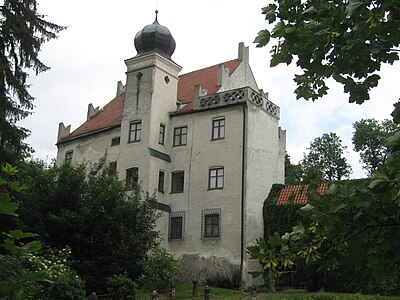
Teisbach Castle, with dome tower and the characteristic gable-sided dovetail battlements
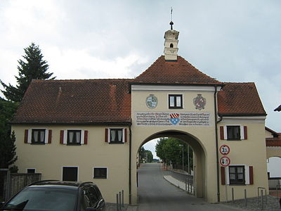
Teisbach market gate, seen from the market square
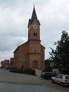
Parish Church of St. Vitus


Web links
- Teisbach in the location database of the Bayerische Landesbibliothek Online . Bavarian State Library
- Teisbach Castle
- The market gate in Teisbach Pictures from the series Kirchen der Heimat
- Parish Church St. Vitus in Teisbach Pictures from the series Churches of the Homeland
Individual evidence
- ↑ a b Bavarian State Office for Statistics and Data Processing (Ed.): Official local directory for Bavaria, territorial status: May 25, 1987 . Issue 450 of the articles on Bavaria's statistics. Munich November 1991, DNB 94240937X , p. 170 ( digitized version ).
- ↑ Bavarian State Statistical Office (Hrsg.): Historical municipality register: The population of the municipalities of Bavaria in the period from 1840 to 1952 (= contributions to Statistics Bavaria . Issue 192). Munich 1954, DNB 451478568 , urn : nbn: de: bvb: 12-bsb00066439-3 .
- ^ Bavarian State Statistical Office (ed.): Official place directory for Bavaria . Issue 335 of the articles on Bavaria's statistics. Munich 1973, DNB 740801384 , p. 66 ( digitized version ).
- ↑ City of Dingolfing: Dingo city bus system ( Memento of the original from February 19, 2012 in the Internet Archive ) Info: The archive link was inserted automatically and has not yet been checked. Please check the original and archive link according to the instructions and then remove this notice.
- ^ A b Anton Eckardt: District Office Dingolfing, p. 167.
- ^ Georg Döllinger: Basics of a Bavarian regent and state history. Nordlingen 1843
- ↑ a b Georg Schwarz: Vilsbiburg
- ↑ gateway-bayern.de Bavarian State Statistical Office: Bavarian municipal and district statistics. Volume 2: Lower Bavaria. Munich 1942, map supplement (= volume 132/2 of the articles on Bavaria's statistics)
- ↑ Adolph von Schaden, Königl. Government of the Isar District: Topographical-Statistical Handbook for the Isar District in the Kingdom of Baiern, 1825: Alphabetical list of all the cities, markets, villages, hamlets, wastelands, etc. located in the Isar District, including precise details of the district court, tax office and community districts, such as the Families, male and female souls, then the number of houses
- ^ Repertory of the topographical atlas sheet Landau, 1846 , p. 61.
- ↑ Joseph von Hazzi: Statistical information about the heart of Bavaria drawn from genuine sources. A general contribution to the study of countries and people. Fourth volume. Third and final section. Nuremberg 1808 , p. 161.
- ^ Description of the coat of arms of Teisbach
- ^ Wilhelm Volkert (ed.): Handbook of Bavarian offices, communities and courts 1799–1980 . CH Beck, Munich 1983, ISBN 3-406-09669-7 , p. 447 .
- ^ Dynamic Center Dingolfing
- ^ Ludger Gallenmüller: Tavern dying in Teisbach. In: Dingolfinger Anzeiger, No. 22, January 27, 2018, p. 1.
- ^ Deanery Dingolfing