Teisbach (Isar)
| Teisbach | ||
|
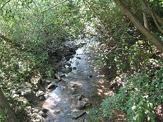
The Teisbach from the footbridge to the Kreuzweg after Heimlichleiden upstream |
||
| Data | ||
| Water code | DE : 167572 | |
| location |
Bavaria
|
|
| River system | Danube | |
| Drain over | Seepage ditch → Isar → Danube → Black Sea | |
| source | Source tube above the former extinguishing water pond of Wornstorf 48 ° 34 '46 " N , 12 ° 26' 24" O |
|
| Source height | 464 m above sea level NHN | |
| muzzle | in the right Dingolfinger Sickergraben coordinates: 48 ° 37 '46 " N , 12 ° 27' 49" E 48 ° 37 '46 " N , 12 ° 27' 49" E |
|
| Mouth height | 356 m above sea level NHN | |
| Height difference | 108 m | |
| Bottom slope | 13 ‰ | |
| length | 8.5 km | |
| Catchment area | 13.38 km² | |
| Left tributaries | Piegendorf Bach | |
| Reservoirs flowed through | former fire pond of Wornstorf | |
|
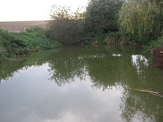
Spring pond with a spring pipe on the west bank |
||
The Teisbach is a right tributary of the lower Isar in the Lower Bavarian district of Dingolfing-Landau . The name of the torrent comes from tiusan - tosen - Tosender Bach = Teisbach.
geography
The upper part of the Teisbach flows through the Weigendorf district of the municipality of Loiching and its lower part through the Teisbach district of the same name in the town of Dingolfing in Lower Bavaria. Its source is located south of the hamlet of Wornstorf (source pipe of the former extinguishing water pond of Wornstorf a good 300 meters east of the watershed to the parallel-flowing Scheiblbach in Steinberg ( location ), which reaches a maximum height of 486 meters . With the exception of the uppermost section, which is around 560 meters long and runs from west to east, the district road DGF 16 follows a little to the west . Shortly after the piped crossing under the road, the Teisbach bends to the north-northeast. At the southern edge of the Dingolfing reservoir, it flows into the right-hand Dingolfing Sickergraben ( receiving water ), which flows into the Isar, roughly following the lake shore in the east, immediately below the Dingolfing hydropower station .
The valley of the Teisbach to the edge of the lake is largely asymmetrical, with wooded steep slopes on the right in the east and agricultural flat slopes on the left in the west, on which there are some hamlets and villages , including Goben, Maßendorf, Piegendorf and Oberteisbach . In the area of Teisbach, the slopes on the left are also steep. Only then, on its last 700 meters, does the stream flow on the flat floor of the Isar valley.
A nearly 1,100 meter long section east of Oberteisbach runs underground. The Piegendorfer Bach also flows underground.
The Teisbach has a catchment area of 13.38 km² and - together with the 1.7 km long drainage ditch section - a length of 8.5 km.
Geotopes
A 1200 meters long and 84 hectares large, fully east district road DGF 16 lying part of the Teisbachtals is from the Bavarian Environment Agency as Geotop type Asymmetric valley expelled.
To the south of this, on the right steep slope of the valley, the former gravel pit of Maßendorf is identified as a geotope of the typification layer sequence, animal fossils , with an area of 1200 square meters.
history
From 1251 the Teisbach is mentioned as the border between the newly founded town of Dingolfing and the rule Teisbach, and from 1386 as the border between the regional courts of Dingolfing and Teisbach. At the latest since the municipal edict at the beginning of the 19th century, any border function has ceased to exist.
According to the repertory of the Topographisches Atlasblatt von Landau (1846), there were four wooden mills with five grinding courses on the water in the area of the Teisbach market . Four mills are already mentioned in Joseph von Hazzi (1808).
As can be seen on the original position sheet 503 Dingolfing from 1866, the Teisbach flows into the Kling Graben (Klinggraben), a right tributary of the Isar, at about 47.73 kilometers at the Kupferstein , with the end of the 19th century as part of the Isar regulation this arm of the Isar or its narrow remnant became the upper part of the Dingolfing Stadtmühlbach , which was diverted from the Isar at km 49.2 (around 570 meters above the Teisbacher Isar bridge). Then the Teisbach flowed into the Dingolfing Stadtmühlbach up to the construction of the Dingolfing reservoir (completed in 1957). Since then it has been flowing into the right Dingolfinger Sickergraben, which in turn is directly below the hydropower plant at 352 m above sea level. NN from the right the Isar flows in and a few meters beforehand some of the water discharges into the Dingolfinger Stadtmühlbach. The upper part of Stadtmühlbach (Klinggraben) was drained in the following years, as was the former mouth of the Teisbach.
The Teyspach as the western border of the then regional court Dingolfing on the land panels 11 and 15 by Philipp Apian 1568 (excerpts)
Individual evidence
- ↑ a b Height according to the contour diagram on: BayernAtlas of the Bavarian State Government ( notes )
- ↑ a b Length and catchment area according to: List of brook and river areas in Bavaria - Isar river area, page 90 of the Bavarian State Office for the Environment, as of 2016 (PDF; 2.5 MB)
- ↑ Josef Hastreiter (Ed.): 100 years of the Dingolfing district. Home register of the district of Dingolfing. Landau 1962, p. 243
- ↑ Geotope Cadastre Bavaria: Teisbachtal
- ^ Geotope cadastre Bavaria: Former gravel pit Massendorf
- ^ Georg Schwarz: Vilsbiburg
- ^ Repertory of the topographical atlas sheet Landau, 1846 , p. 61
- ↑ Joseph von Hazzi: Statistical information about the heart of Bavaria drawn from genuine sources. A general contribution to the study of countries and people. Fourth volume. Third and final section. Nuremberg 1808 , p. 161
- ^ Original position sheet 503 Dingolfing
- ↑ historical Flurname who still in the street name on the copper stone in Teisbach and copper stone road continues
- ↑ TK 25, sheet Dingolfing West, 1955
- ↑ Josef Sailer: The side canals of the Isar with their engines between Landshut and Gottfrieding. October 1930 (manuscript), p. 68
- ↑ Ursula Zavesky: The mill system in the Dingolfing area - a contribution to the economic history of Lower Bavaria. Approval work for the first examination for the teaching profession at elementary schools (VPO I of March 4, 1964), pp. 21–22
- ↑ TK 25, sheet Dingolfing West, 1958 The map sheet from 1958 also shows the old course (before the drainage).
Web links
- Course and catchment area of the Teisbach on the BayernAtlas
- Catchment area of the Teisbach on the map service of water management, FGN Bavarian State Office for the Environment ( information )
- LÄNGST & VOERKELIUS the LANDSCAPE ARCHITECTS: IMPLEMENTATION CONCEPT FOR HYDROMORPHOLOGICAL MEASURES to Gew. III. Order for the FWK 1_F433 (formerly IS 374 and IS 375). EXPLANATORY REPORT, Landshut 2015


