
Höfen (Dingolfing)
|
Yards
City of Dingolfing
Coordinates: 48 ° 38 ′ 19 ″ N , 12 ° 26 ′ 20 ″ E
|
|
|---|---|
| Height : | 360 m |
| Residents : | 755 (Jun 30, 2018) |
| Postal code : | 84130 |
| Area code : | 08731 |
 Location of the Teisbach market in what was then the district of Dingolfing in 1961. Höfen, Schönbühl and Gaubitzhausen are located in the part north of the Isar .
|
|
_Orthofoto.jpg)
(accessed in May 2012 before development of the building area)


Höfen is one of the 22 officially named municipal parts of the city of Dingolfing and is located in the Teisbach district . Höfen used to be a village in the Teisbach market , which was incorporated into the town of Dingolfing on January 1, 1972 as part of the regional reform in Bavaria .
geography
The village of Schönbühl adjoins it in the south and the hamlet of Gaubitzhausen in the northeast . The three districts are in close spatial connection in the rural area in the Isar valley to the left of the Isar. The Kronwieden settlement in the west belongs to the Loiching community . The municipal boundary runs partially through the middle of built-up areas. The properties at the western end of the Bachweg (house numbers 42 and 43) border directly on the properties on the Veilchenweg in Kronwieden. The property on Hauptstrasse 2 borders the property on Poststrasse in Kronwieden. The municipal boundary cuts through the BayWa premises on Hauptstrasse 7. Otherwise, the open corridors of Höfen border on Kronwieden, which is now built up to the municipal boundary.
As of June 30, 2011, the village had 390 residents with main residence and 18 with secondary residence according to the population register of the city of Dingolfing . With the completion of the Höfen II residential area with 105 parcels, an increase of around 315 inhabitants was expected. After completion and occupation of most of the new residential buildings seven years later, as of June 30, 2018, the number of residents with main residence was already 755 (18 secondary residences). According to the proposal of the building committee, the new buildings have the street address "Im Unteren Moosfeld".
In the southeast of the village is a quarry pond , which is locally known as Birkensee .
The A 92 runs along the northern border of the former municipal area. At the BMW Dynamic Center, where the DGF-16 runs over the A 92, the third motorway junction in the city of Dingolfing and the first in the former municipality were opened to traffic on December 9, 2014. The DGF-16 had already been dismantled to the north in the direction of Dornwang, or relocated around 1500 meters to the east over the roundabout at Grüblhof. The level crossing in Höfen, which was only equipped with flashing lights, was closed to through traffic. The originally intended removal is not carried out because of the agricultural traffic.
history
Historically, Höfen developed from two rural settlements of the same name, of which the western and originally smaller one was assigned to the Teisbach market, while the eastern and older in the area of today's Schwalbenweg was added to the community of Loiching when the community was formed in 1818. The border between the two villages ran roughly along today's Lerchenstrasse. It was not until January 1, 1946, when the Loichinger part (together with Schönbühl and Gaubitzhausen) was incorporated into the Teisbach market that the communal border and the district border within Höfen were abolished. Until that time, the Teisbacher village courtyards formed a 170 hectare large enclave that was completely surrounded by Loichinger municipality.
Today's village area to the left (north) of the Längenmühlbach has been used as a pasture area for centuries . Farmers from the Teisbach market already had grazing rights here in the late Middle Ages . Arable farming and thus increasingly livestock with stable feeding did not begin here until the end of the 18th century.
In a list of the holdings of the Teisbach Regional Court in 1752, Höfen appears as the only place of the Höfen Obmannschaft in Schwaigen , one of six Obmannschafts of the Teisbach Office. The villages of Schönbühl and Gaubitzhausen, which were later identified separately, were thus subsumed under Höfen, as was Kronwieden , which still belongs to the Loiching community today , which still belonged to Höfen in the 1809 ownership and was only recorded as a separate district in the 1840 community register. The place or the chairmanship also included the Grüblhof ( "Wirtshaus am Grieblhof" ), which was later also run as a separate district, but to which the Rostmühle (later also known as Mosermühle ) belonged. This list showed a total of 16 properties of various sizes, four of which were under foreign jurisdiction (Hofmark Warth). The place is recorded on Adrian von Riedl's map from 1802 as Höfer silent with the Grieblhof .
Schönbühl appears in the list as an eighth property Kurf. Box Teisbach (Müller on the Schönbichlmühle) . The area of this chairmanship Höfen in Schwaigen was added to the community of Loiching in 1818 when the community was formed. Nine of the twelve properties of the chairmanship had court names that ended in * schwaige , even if the individual properties cannot be precisely located: Schererschwaige, Kanzlerschwaige, Hansenschwaige, Dräxlerschwaige, Demblschwaige, Räckerschwaige, Rohrerschwaige, Wörtherschwaige and Moosschwaige. The other three properties were the aforementioned Müller on the Schönbichlmühle (Schönbühl), the Wirtshaus am Grieblhof (Grüblhof) and the Auhäusl . Räckerschwaige and Wörtherschwaige are qualified as an extension to the host .
The hamlet of the same name, which had been part of the Teisbach market for some time as an exclave, consisted of only four properties according to this list from 1752. Three properties were 1/8 each (Fischersölde, Furtnersölde, Eberlsölde) and one 1/16 (Weberhäusl). The hamlet is listed on Adrian von Riedl's map from 1802 as Teisbacherhöfe .
In Hazzi (1808) courtyards immersed in the Official Teisbach with 17 houses and as many hearths on. It should be noted that there are three mills in the village .
The topographical-statistical manual for the Isar district in the Kingdom of Baiern from 1825 contains the following entries, which concern farms (only within the municipality of Loiching), as well as the localities subsumed under farms at other times:
- Courtyards (119 inhabitants in 23 houses)
- Grüblhof (12 residents in 1 house)
- Schönbichl (6 residents in 1 house)
In the Bavarian register of places from 1831/1832, within the then Vilsbiburg Höfen district court, only appears once: Village of the districts Vilsbiburg and the Rev. Loiching, 2 1/4 hours from Wörth. It consists of 23 H. with 120 E. and is located on the Isar. In this work, Gaubitzhausen (as a wasteland) and Schönbühl (as a wasteland Schönbichel with 6 inhabitants) are listed separately. The Grüblhof, which was incorporated into the town of Dingolfing in 1946, also appears: Grübelhof: Solitude on the road from Landshut to Deggendorf not far from Loiching, in the district of Vilsbiburg. It contains 12 E. and is located 2 1/2 St. from Wörth. Neuhausen is also listed : Solitude on the road from Landshut to Deggendorf, not far from Teisbach and Loiching, in the district of Vilsbiburg, 2 1/8 hours from Wörth . This place, which is also marked on historical official maps north of the road from Landshut to Deggendorf (today's main road or state road 2074) and west of today's Lerchenstraße, does not appear in later official place directories and is now unknown as a place name. Immediately to the west of this is the Höfen I building area with 35 residential units.
The register of the diocese of Regensburg from 1838 lists Höfen only once among the places belonging to the Teisbach branch at that time , obviously including Schönbühl and Gaubitzhausen, as these do not appear there: Höfen or Teisbacher- Schwaigen , 23 houses, 144 souls.
The first official register of localities in Bavaria as of 1875, on the other hand, separated according to community affiliation: The village of Höfen of the municipality of Loiching (71 buildings, 116 inhabitants, and separately listed the hamlets of Gaubitzhausen and Schönbühl with 11 buildings and 14 residents and 5 buildings and 15 residents), and the hamlet of Höfen des Markt Teisbach (23 buildings, 67 inhabitants).
The incorporation of the part of Höfen, which previously belonged to Loiching, as well as the districts of Schönbühl and Gaubitzhausen in what was then Markt Teisbach on January 1, 1946, which rounded off the municipality of Teisbach and removed the exclave status of the Teisbach district of Höfen, is included for the first time in the official register of places from 1950 reflected (Höfen 415 inhabitants in 67 residential buildings, hamlet Gaubitzhausen 25 inhabitants in 6 residential buildings and village Schönbühl 88 inhabitants in 14 residential buildings).
Architectural monuments
The Wegkapelle at house number 49 on the north side of the main street (Staatsstrasse 2074), locally known as the Ernst Chapel after the owner, is one of the three listed buildings in Höfen . The small gable roof building with facade structure dates from the second half of the 19th century. Until a few decades ago, May devotions were held here regularly .
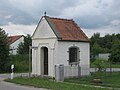
Chapel from the southeast

inside view
_au%C3%9Fen.jpg)
_innen.jpg)
literature
- Joseph Wolfgang Eberl: The history of the city of Dingolfing and its surroundings . F. Datterer, Freising 1856
- Hermann Raith: The conflict between the parishes of Teisbach and Loiching about the so-called "Teisbacher Enclave". A legal historical contribution to the problem of community formation in Bavaria in the 19th and 20th centuries . Eichendorf 2007, ISBN 978-3-930648-70-2 .
Web links
Individual evidence
- ↑ Bavarian State Office for Statistics and Data Processing (Ed.): Official local directory for Bavaria, territorial status: May 25, 1987 . Issue 450 of the articles on Bavaria's statistics. Munich November 1991, DNB 94240937X , p. 170 ( digitized version ).
- ↑ Bayernviewer ( Memento of the original from March 4, 2016 in the Internet Archive ) Info: The archive link was inserted automatically and has not yet been checked. Please check the original and archive link according to the instructions and then remove this notice.
- ↑ Parallel market research and selection process according to No. 6.4.1 of the Bavarian Broadband Directive . ( Page no longer available , search in web archives ) Info: The link was automatically marked as defective. Please check the link according to the instructions and then remove this notice. (PDF; 67 kB) City of Dingolfing; Directive no longer in force since July 9, 2014, new directive without 6.4.1 announced in FMBl No. 8/2014 (PDF; 2.4 MB)
- ↑ City Dingolfing: Dingolfing city brochure (2018)
- ↑ Showcase, Volume 22 / No. 66, July 2012, page 2: The plots are measured ( page no longer available , search in web archives ) Info: The link was automatically marked as defective. Please check the link according to the instructions and then remove this notice. (PDF; 2.4 MB)
- ↑ Landshut State Archives, Teisbach Rent Office, Teisbach Tax District, Property Version 1809, Volume 2, No. 20, quoted from: Bernd Stadlbauer: Der Altlandkreis Dingolfing (Historical Atlas of Bavaria, Part of Old Bavaria, Issue 65), Munich 2015, ISBN 978-3- 7696-6557-4 , p. 388. The Schönbichlmühle , then called the Schönbichlmühle, was on the Längenmühlbach and is now a small hydroelectric power station .
- ^ Georg Schwarz: Vilsbiburg. The origin and development of the forms of rule in the Lower Bavarian region between the Isar and Rott. Historical Atlas of Bavaria, part of Old Bavaria, issue 37. Page 336
- ^ Georg Schwarz: Vilsbiburg. The origin and development of the forms of rule in the Lower Bavarian region between the Isar and Rott. Historical Atlas of Bavaria, part of Old Bavaria, issue 37, page 406
- ^ Bernd Stadlbauer: Dingolfing. Historical Atlas of Bavaria, part of Old Bavaria, issue 65, page 333
- ^ Georg Schwarz: Vilsbiburg. The origin and development of the forms of rule in the Lower Bavarian region between the Isar and Rott. Historical Atlas of Bavaria, part of Old Bavaria, issue 37, page 400
- ↑ Joseph von Hazzi: Statistical information about the heart of Bavaria drawn from genuine sources. A general contribution to the study of countries and people. Fourth volume. Third and final section. Nuremberg 1808 , p. 146
- ↑ Adolph von Schaden, Königl. Government of the Isar District: Topographical-Statistical Handbook for the Isar District in the Kingdom of Baiern, 1825: Alphabetical index of all cities, markets, villages, hamlets, desert areas and the like located in the Isar District. s. w. In addition to precise details of the district court, rent office and community districts, as well as families, male and female souls, then the number of houses
- ↑ Joseph Anton Eisenmann and Carl Friedrich scorn topo-geographical-statistical Lexicon from the kingdoms of Bavaria or alphabetic description of all etc circuits contained in the kingdom of Bavaria, towns, market towns, villages, hamlets, farms, castles, deserts, mountains, superb mountains and forests , First volume, AL, Erlangen 1831, page 769
- ↑ Joseph Anton Eisenmann and Carl Friedrich scorn topo-geographical-statistical Lexicon from the kingdoms of Bavaria or alphabetic description of all etc circuits contained in the kingdom of Bavaria, towns, market towns, villages, hamlets, farms, castles, deserts, mountains, superb mountains and forests , Second volume, MZ, Erlangen 1832, page 604
- ↑ ibid., Page 146
- ↑ Bayernviewer: Original position sheets ( Memento of the original from December 22, 2015 in the Internet Archive ) Info: The archive link was inserted automatically and has not yet been checked. Please check the original and archive link according to the instructions and then remove this notice.
- ↑ City of Dingolfing Online: Building areas ( Memento of the original from September 6, 2012 in the Internet Archive ) Info: The archive link was automatically inserted and not yet checked. Please check the original and archive link according to the instructions and then remove this notice.
- ↑ Josepf Lipf (Editor): matrikel bishopric of Regensburg . Ed .: Diocese of Regensburg. Pustet, Regensburg 1838, p. 70 ( digitized version ).
- ↑ Kgl. Statistical Bureau (ed.): Complete list of localities of the Kingdom of Bavaria. According to districts, administrative districts, court districts and municipalities, including parish, school and post office affiliation ... with an alphabetical general register containing the population according to the results of the census of December 1, 1875 . Adolf Ackermann, Munich 1877, 2nd section (population figures from 1871, cattle figures from 1873), Sp. 432 , urn : nbn: de: bvb: 12-bsb00052489-4 ( digitized version ).
- ↑ Kgl. Statistical Bureau (ed.): Complete list of localities of the Kingdom of Bavaria. According to districts, administrative districts, court districts and municipalities, including parish, school and post office affiliation ... with an alphabetical general register containing the population according to the results of the census of December 1, 1875 . Adolf Ackermann, Munich 1877, 2nd section (population figures from 1871, cattle figures from 1873), Sp. 437 , urn : nbn: de: bvb: 12-bsb00052489-4 ( digital copy ).
- ↑ Bavarian State Statistical Office (ed.): Official place directory for Bavaria - edited on the basis of the census of September 13, 1950 . Issue 169 of the articles on Bavaria's statistics. Munich 1952, DNB 453660975 , Section II, Sp. 410 ( digitized version ).
- ↑ Bavarian State Office for Monument Preservation: Dingolfing (PDF; 153 kB)