
Vilshofen district
| coat of arms | Germany map | |
|---|---|---|

|
Coordinates: 48 ° 38 ' N , 13 ° 11' E |
|
| Basic data (as of 1972) | ||
| State : | Bavaria | |
| Administrative region : | Lower Bavaria | |
| Administrative headquarters : | Vilshofen | |
| Area : | 599.94 km 2 | |
| Residents: | 56,050 (May 27, 1970) | |
| Population density : | 93 inhabitants per km 2 | |
| License plate : | VOF | |
| Circle key : | 09 2 50 | |
| Circle structure: | 47 parishes | |
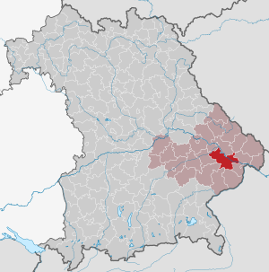
| Location of the Vilshofen district in Bavaria | ||
  |
||

The district of Vilshofen was part of the Bavarian administrative district of Lower Bavaria . Its former area is now part of the Deggendorf and Passau districts .
geography
Important places
The largest places were Vilshofen , Osterhofen , Aidenbach and Windorf .
Neighboring areas
The district bordered clockwise to the north, beginning with the districts of Deggendorf , Grafenau , Passau , Griesbach im Rottal , Pfarrkirchen , Eggenfelden and Landau an der Isar .
history
district Court
In 1803, in the course of the administrative restructuring of Bavaria, the district court of Vilshofen was established. After the establishment of the Kingdom of Bavaria, this was added to the Lower Danube District, whose capital was Passau.
In 1838 the Lower Danube District was renamed the District of Lower Bavaria , from which the administrative district of the same name emerged . The district capital was moved to Landshut. In the course of this administrative reform, the Vilshofen Regional Court had to cede its western communities to the newly established Osterhofen Regional Court .
District Office
The district office of Vilshofen was formed in 1862 through the merger of the regional courts of the older order Osterhofen and Vilshofen.
On the occasion of the reform of the layout of the Bavarian district offices, the Vilshofen district office received the Eging municipality of the Passau district office on January 1, 1880 .
district
On January 1, 1939, the term rural district was introduced throughout the empire. Thus the Vilshofen district office became the Vilshofen district.
The county was Vilshofen until the dissolution of one of the richest districts of Bavaria due in Pleinting located oil power plant , which is owned by Bayernwerk AG was and today energy E.ON belongs.
On July 1, 1972, the Vilshofen district was dissolved:
- The city of Osterhofen and the communities of Aholming , Aicha an der Donau , Altenmarkt , Anning, Buchhofen , Forsthart , Galgweis , Gergweis , Göttersdorf, Kirchdorf b. Osterhofen, Künzing , Langenamming , Langenisarhofen , Moos , Neusling, Neutiefenweg , Niedermünchsdorf , Niederpöring , Oberpöring , Ottmaring , Ramsdorf , Wallerfing and Wisselsing came to the Deggendorf district .
- The city of Vilshofen and the communities of Aidenbach , Albersdorf, Aldersbach , Alkofen , Aunkirchen , Beutelsbach , Eging , Garham, Haidenburg , Hofkirchen , Kirchberg , Königbach, Ortenburg , Otterskirchen , Pleinting , Rathsmannsdorf , Walchsing , Windorf , Wolfachau and Zeitlarn came to the Passau district .
Population development
| year | Residents | source |
|---|---|---|
| 1864 | 37,468 | |
| 1885 | 42,482 | |
| 1900 | 42,568 | |
| 1910 | 44,085 | |
| 1925 | 45,777 | |
| 1939 | 47,038 | |
| 1950 | 62,800 | |
| 1960 | 53,300 | |
| 1971 | 56,400 |
Communities
Before the start of the Bavarian regional reform, the Vilshofen district comprised 47 municipalities:
|
|
The municipality of Oberndorf was incorporated into Galgweis on January 1, 1964 and is now part of Osterhofen.
License Plate
On July 1, 1956, the district was assigned the distinctive sign VOF when the vehicle registration number that is still valid today was introduced . It was issued until April 28, 1973.
literature
- Karl Wild, Rudolf Hilmer: Vilshofen district. The picture of the Vilshofen district. Vilshofen district, Vilshofen 1966.
- Franziska Jungmann-Stadler: Vilshofen district. The historical area of the district courts of Vilshofen and Osterhofen (= Historical Atlas of Bavaria. Part: Old Bavaria. Row 1, Vol. 29). Commission for Bavarian State History, Munich 1972, ISBN 3-7696-9875-4 .
Individual evidence
- ^ Wilhelm Volkert (ed.): Handbook of Bavarian offices, communities and courts 1799–1980 . CH Beck, Munich 1983, ISBN 3-406-09669-7 , p. 585 .
- ^ Wilhelm Volkert (ed.): Handbook of Bavarian offices, communities and courts 1799–1980 . CH Beck, Munich 1983, ISBN 3-406-09669-7 , p. 97 .
- ^ Federal Statistical Office (ed.): Historical municipality directory for the Federal Republic of Germany. Name, border and key number changes in municipalities, counties and administrative districts from May 27, 1970 to December 31, 1982 . W. Kohlhammer, Stuttgart / Mainz 1983, ISBN 3-17-003263-1 , p. 625 .
- ^ Ordinance on the reorganization of Bavaria into rural districts and independent cities of December 27, 1971
- ^ Eugen Hartmann: Statistics of the Kingdom of Bavaria . Ed .: Royal Bavarian Statistical Bureau. Munich 1866, population figures of the district offices 1864 ( digitized version ).
- ↑ Royal Bavarian Statistical Bureau (ed.): Localities directory of the Kingdom of Bavaria . Munich 1888, population figures of the district offices 1885 ( digitized ).
- ↑ a b www.gemeindeververzeichnis.de
- ^ Localities directory for the Free State of Bavaria, based on the census of June 16, 1925
- ↑ Statistical Yearbook for the German Reich 1940
- ↑ Statistical Yearbook for the Federal Republic of Germany 1952
- ↑ Statistical Yearbook for the Federal Republic of Germany 1961
- ↑ Statistical Yearbook for the Federal Republic of Germany 1973
- ^ Official register of places for Bavaria 1964
Aichach | Alzenau i.UFr. | Amberg | Bad Aibling | Bad Neustadt adSaale | Bad Toelz | Beilngries | Berchtesgaden | Bow | Brückenau | Burglengenfeld | Dingolfing | Dinkelsbühl | Donauwörth | Ebermannstadt | Boars | Eggenfelden | Erlangen | Eschenbach idOPf. | Feuchtwangen | Friedberg | Feet | Gemünden a.Main | Gerolzhofen | Grafenau | Griesbach i.Rottal | Gunzenhausen | Hammelburg | Hassfurt | Hersbruck | Hilpoltstein | Höchstadt adAisch | Hofheim i.UFr. | Illertissen | Ingolstadt | Karlstadt | Kaufbeuren | Kemnath | Kempten (Allgäu) | Königshofen i.Grabfeld | Kötzting | Krumbach (Swabia) | Landau adIsar | Lauf adPegnitz | Running | Lohr a.Main | Mainburg | Mallersdorf | Marktheidenfeld | Marktoberdorf | Mellrichstadt | Memmingen | Mindelheim | Münchberg | Nabburg | Naila | Neuburg adDonau | Neunburg vorm Wald | Neustadt adAisch | Nordlingen | Nuremberg | Obernburg am Main | Oberviechtach | Ochsenfurt | Parsberg | Pegnitz | Parish churches | Rehau | Riedenburg | Roding | Rothenburg ob der Tauber | Rottenburg adLaaber | Scheinfeld | Schongau | Schrobenhausen | Schwabach | Schwabmünchen | Sonthofen | Stadtsteinach | Staffelstein | Straubing | Sulzbach-Rosenberg | Uffenheim | Viechtach | Vilsbiburg | Vilshofen | Vohenstrauss | Waldmünchen | Wasserburg a.Inn | Wegscheid | Weilheim i.OB | Weißenburg i.Bay. | Wertingen | Wolfratshausen | Wolfstein
1939–1945 affiliated districts: Bergreichenstein | Eisenstein market | Prachatitz