
Röttingen
| coat of arms | Germany map | |
|---|---|---|

|
Coordinates: 49 ° 30 ' N , 9 ° 58' E |
|
| Basic data | ||
| State : | Bavaria | |
| Administrative region : | Lower Franconia | |
| County : | Wurzburg | |
| Management Community : | Röttingen | |
| Height : | 243 m above sea level NHN | |
| Area : | 27.2 km 2 | |
| Residents: | 1668 (Dec. 31, 2019) | |
| Population density : | 61 inhabitants per km 2 | |
| Postal code : | 97285 | |
| Area code : | 09338 | |
| License plate : | WÜ , OCH | |
| Community key : | 09 6 79 182 | |
| LOCODE : | DE RTT | |
| City structure: | 4 districts | |
City administration address : |
Marktplatz 1 97285 Röttingen |
|
| Website : | ||
| Mayor : | Hermann Gabel, called Fernando (future Röttingen) | |
| Location of the city of Röttingen in the Würzburg district | ||
 |
||


Röttingen is a country town in the Lower Franconian district of Würzburg and the seat of the Röttingen administrative community .
geography
Röttingen is about 35 kilometers south of Würzburg in Bavaria, right on the border with Baden-Württemberg . It is the southernmost city in the Würzburg district .
City structure
Four districts belong to Röttingen:
- Aufstetten
- Gutter mill
- Röttingen
- Strüth
There are the districts Aufstetten, Röttingen and Strüth.
climate
Despite the abundance of water in the valley area, the deaf area belongs to the relatively dry areas of Franconia and is characterized by features of the continental, dry-warm climate type with low amounts of precipitation. More than 30 summer days with temperatures above 25 ° C and fewer than ten frost days with temperatures below 0 ° C are counted annually.
history
Until the church is planted
The exact founding time of the city is in the dark. The Alemannic clan of the Ruoter Röttingen (Ruotingen) may not have been founded until the late 5th century . The first reliable documentary tradition comes from the year 1103. Röttingen has had city rights since 1275 . In 1298 the city was the starting point for the Rintfleisch pogrom and in 1336 for the Armleder uprising, which was also anti-Jewish . During the time of the tribal duchies, the place was in the Duchy of Franconia .
Originally belonging to the nobles of Hohenlohe , Röttingen came under the sovereignty of the Würzburg monastery . From the 14th century on, Röttingen was the seat of a bailiff who was considered the extended arm of the Würzburg prince-bishop.
The Peasants' War did not leave Röttingen unaffected and brought economic life to a standstill. It was only under the long-standing regiment of Prince-Bishop Julius Echter von Mespelbrunn that the city's economy , which was largely dependent on viticulture, strengthened . In the Thirty Years' War (1618–1648) Röttingen suffered a lot from looting and robbery, because at the time of Gustav Adolf the Taubertal was a theater of war for a long time. The wars of the 16th and 17th centuries again brought the city and its citizens to the brink of ruin. It took a Napoleon to put an end to the Frankish small-state individualism between 1803 and 1814. In 1818 the political municipality was established.
19th and 20th centuries
With the secularization the clerical principality was dissolved and Röttingen was added to the Bavarian Lower Main District. In the Kingdom of Bavaria, Franconia was divided into the administrative districts of Upper, Middle and Lower Franconia in 1837. In 1919 Röttingen became self-governing.
Formerly there was a railway connection from Ochsenfurt am Main to Röttingen in Lower Franconia with the 36.5 km long Gaubahn of the Bavarian State Railways from April 30, 1907, which was extended on November 17, 1909 to Weikersheim on the Crailsheim – Königshofen railway line ; It also received a 6.1 kilometer branch from Bieberehren to Creglingen in the Taubertal, but the planned extension to Rothenburg ob der Tauber never came true. While passenger traffic ended in 1974 and 1967, respectively, there was freight traffic until the early 1990s, which ended prematurely because of a dilapidated bridge between Röttingen-Schäftersheim. Then the route was dismantled and largely converted into a cycle path ( Taubertal cycle path and Gaubahn cycle path ).
Since 1953 Röttingen has been called " European City ".
Incorporations
On January 1, 1972, the previously independent municipality of Strüth was incorporated. On January 1, 1978, Aufstetten was added.
Population development
- 1961: 2024 inhabitants
- 1970: 1988 inhabitants
- 1987: 1733 inhabitants
- 1991: 1751 inhabitants
- 1995: 1775 inhabitants
- 2000: 1789 inhabitants
- 2002: 1781 inhabitants
- 2005: 1675 inhabitants
- 2006: 1663 inhabitants
- 2007: 1674 inhabitants
- 2008: 1675 inhabitants
- 2009: 1650 inhabitants
- 2010: 1657 inhabitants
- 2011: 1700 inhabitants
- 2012: 1706 inhabitants
- 2013: 1711 inhabitants
- 2014: 1687 inhabitants
- 2015: 1705 inhabitants
- 2016: 1713 inhabitants
religion
Denomination (rounded):
- Roman Catholic 94%
- Protestant 4%
- other 2%
politics
City council
Distribution of seats after the local elections on March 15, 2020 (the seats after the 2014 election in brackets):
- CSU / Free Citizens: 7 seats (7)
- Independent citizens of Röttingen (UBR): 5 seats (5)
mayor
The local elections on March 15, 2020 brought the following result:
Hermann Gabel, called Fernando (Zukunft Röttingen) was elected as the new mayor with 60.99% of the vote. His predecessor was Martin Umscheid (CSU / Free Citizens), in office from May 1, 2008 to April 30, 2020.
Röttingen is the seat of an administrative community with the following member communities: Bieberehren, Riedenheim, Röttingen, Tauberrettersheim. The chairman of the Röttingen administrative association is the Mayor of Röttingen, Hermann Gabel, known as Fernando.
coat of arms
The coat of arms is derived from the seal guide in 1400 and is as follows described : "In red of the standing Saint George in silver armor with a red cross on his chest, in his right hand on golden lance a silver flag on a continuous red cross; on the left arm a silver tartsche with a red cross hanging from the shackle.
Town twinning
A partnership exists with Bad Mitterndorf in Styria , Austria .
economy
Röttingen is a Franconian wine town on the Tauber . Approx. 30 hectares of Franconian wine are currently being grown in the Röttinger Feuerstein site : 70% of this is Müller-Thurgau , 20% Silvaner ; ten percent varieties such as Riesling , Traminer , Kerner , Scheurebe , Bacchus , Schwarzriesling etc. The specialty is Tauberschwarz , a centuries-old local grape variety that is grown and expanded exclusively in the Tauber region.
Culture and sights
Theater festival
The Röttingen Franconian Festival (formerly the Röttinger Festival) has been held every year since 1984 in the courtyard of Brattenstein Castle .
Museums
- Wine museum in Brattenstein Castle: documents the history of viticulture in Röttingen (Lagerweg)
- Museum vineyard: A museum vineyard was created in the "Feuerstein" vineyard. It documents the development of viticulture up to the 1950s on an area of 1,800 square meters with three parcels.
Historical buildings
- A good number of half-timbered houses around the market square and in the entire old town
- Baroque town hall (around 1750), Marktplatz 1, three-storey solid building, house structure, mansard roof with bell tower, wrought-iron gargoyles
- Brattenstein Castle (first mentioned in a document in 1230), square layout, in the core 12th / 13th century. Century, changed in the early 17th century, further changes in the 19th century, remains of the keep and moat;
- Parish church St. Kilian (13th century), hall building, in the core late Romanesque, the choir extensions 14th and 15th centuries, redesigned 1606–1614; with equipment
- Tall building (13th century), tower-like stone building with half-timbered upper floor from the 15th century, former owner: Deutscher Orden
- St. George's Chapel (15th century) Catholic cemetery chapel, rectangular hall building, 1588, with furnishings
- Julius-Echter -Stift, two-storey, elongated Renaissance building, built in 1614/1615 by Julius Echter von Mespelbrunn
- The almost completely preserved city wall still has seven medieval defense towers from the original 14 existing towers from the 14th / 15th centuries. Century: Mill tower, old and new Hundheim gate tower, swineherd tower, Jakob tower, snail tower and Rippacher tower. For the successful renovation of the Jakobsturm and the adjoining house, the city received the Lower Franconian district's award for the preservation of historic buildings in 2009
- The Röttinger Käppele is located on the hill northeast of the village
Others
- Sundial circular route (two kilometers long) with 25 sundial objects (since 1984)
- Paracelsus garden with around 70 medicinal and kitchen herbs directly adjacent to Brattenstein Castle
- Way of the Cross to Käppele (0.5 kilometers long, start opposite Kapellenberg 1–2)

Auditorium in the courtyard of Brattenstein Castle

Franconian half-timbering in Röttingen

Röttingen town hall

Portal of the Julius-Echter-Stift

City wall with snail tower
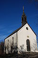
Röttinger Käppele

Snail tower with house in the Erbsengasse

City gate in Röttingen


Biking and hiking trails
Röttingen is on the Taubertal cycle path . The Taubertal panorama trail also leads through the village.
Regular events
- Röttingen Franconian Festival (formerly Röttingen Festival on the Romantic Road): every year from May to mid-August in the courtyard of Brattenstein Castle with a young theater, musical, operetta, drama and concerts; in the early years mainly plays by Johann Nestroy were performed
- European Wine Festival (Pentecost)
- Gauvolksfest Röttingen (end of August)
- Open Monument Day
- Cultural autumn
romantic street
Röttingen is located on the tourist route named by Augsburg Mayor Wegele in 1950 for reasons of tourism promotion . It connects a number of cities with largely preserved medieval city centers in the central area between Würzburg and Augsburg , including Bad Mergentheim , Rothenburg ob der Tauber , Feuchtwangen , Dinkelsbühl , Nördlingen im Ries and Donauwörth .
sons and daughters of the town
- Wolfgang Zobel (* 1523; † 1563), Benedictine abbot of the Münsterschwarzach monastery
- Karl Mühlek (* 1930), Catholic theologian
- Gabi Geist (* 1953), actress
literature
- Georg Menig At home grief and worries and here in the field mutual killing - the city of Röttingen an der Tauber and the First World War, published by the city of Röttingen, Röttingen 2020, 200 pages, Gendi-Verlag (available at the Tourist Information Röttingen)
- Hartmut Eichinger: Photo book series Röttingen in the course of time
- Volume 1: Brattenstein Castle, First Castle Festival, Europastadt , Röttingen 2017, 48 pages, b / w;
- Volume 2: Living and Working , Röttingen 2018, 72 pages, b / w;
- Volume 3: Historical data, buildings and pictures , Röttingen 2018, 104 pages, b / w;
- Volume 4: People, Church, Associations, Festivals , Röttingen 2019, 104 pages, b / w;
- (available from Röttinger Tourist Information, from eibe Röttingen or from the author)
- Hartmut Eichinger: Chronicle of the Eichinger family of carpenters Book about the time since 1448 with reports on 14 generations of carpentry operations in Röttingen, Röttingen 2016 (available from eibe Röttingen or from the author)
- Hartmut Eichinger: Visionen für Kinder Biography of the author with reports on the rise of his father's carpentry business to the company eibe, Röttingen 2017 (available from eibe Röttingen or from the author)
- Dr. Michael Wieland: Röttingen - A contribution to the history of this Franconian country town , original Würzburg 1858, (in the Hartmut Eichinger archive)
- Dr. Michael Wieland: Röttingen - increased and improved contribution to a history of this city , original Würzburg 1904, reprinted by H. Eichinger 1990 (available from H. Eichinger)
Web links
- Official website of the city of Röttingen
- Official website of the Röttingen Franconian Festival
- Entry on the coat of arms of Röttingen in the database of the House of Bavarian History
- History of the Jews in Röttingen
- Beef pogrom
- Röttingen: Official statistics of the LfStat (PDF; 1.05 MB)
Individual evidence
- ↑ "Data 2" sheet, Statistical Report A1200C 202041 Population of the municipalities, districts and administrative districts 1st quarter 2020 (population based on the 2011 census) ( help ).
- ↑ http://www.bayerische-landesbibliothek-online.de/orte/ortssuche_action.html ? Anzeige=voll&modus=automat&tempus=+20111110/211417&attr=OBJ&val= 1817
- ^ Wilhelm Volkert (ed.): Handbook of Bavarian offices, communities and courts 1799–1980 . CH Beck, Munich 1983, ISBN 3-406-09669-7 , p. 545 .
- ↑ a b c Federal Statistical Office (ed.): Historical municipality directory for the Federal Republic of Germany. Name, border and key number changes in municipalities, counties and administrative districts from May 27, 1970 to December 31, 1982 . W. Kohlhammer GmbH, Stuttgart / Mainz 1983, ISBN 3-17-003263-1 , p. 756 .
- ↑ "The Classic" - Tourist Association of Liebliches Taubertal. In: liebliches-taubertal.de. Retrieved August 3, 2020 .
- ↑ 1st day stage - Rothenburg odT to Weikersheim - Tourist Association Liebliches Taubertal. In: liebliches-taubertal.de. Retrieved August 3, 2020 .
- ↑ Panoramaweg Taubertal - Tourist Association Liebliches Taubertal. In: liebliches-taubertal.de. Retrieved August 3, 2020 .
- ↑ Taubertal panorama hiking trail (long-distance hiking trail) - wanderkompass.de. In: wanderkompass.de. Retrieved August 3, 2020 .

Cities: Aub | Eibelstadt | Ochsenfurt | Röttingen
Markets: Bütthard | Eisenheim | Frickenhausen am Main | Gelchsheim | Gable City | Helmstadt | Höchberg | Neubrunn | Randersacker | Reichenberg | Remlingen | Rimpar | Sommerhausen | Winterhausen | Zell am Main
Municipalities: Altertheim | Bergtheim | Bieberehren | Eisingen | Erlabrunn | Estenfeld | Gaukönigshofen | Gerbrunn | Geroldshausen | Greußenheim | Güntersleben | Hausen near Würzburg | Hettstadt | Wooden churches | Kirchheim | Box | Small cattle field | Kürnach | Leinach | Margetshöchheim | Oberpleichfeld | Prosselsheim | Riedenheim | Rottendorf | Sonderhofen | Tauberrettersheim | Theilheim | Thüngersheim | Uettingen | Unterpleichfeld | Veitshoechheim | Waldbrunn | Waldbüttelbrunn
Unregulated areas: Gramschatzer Wald | Guttenberg Forest | Irtenberg Forest