
List of architectural monuments in Röttingen

The monuments of the Lower Franconian town of Röttingen are compiled on this page . This table is a partial list of the list of architectural monuments in Bavaria . The basis is the Bavarian Monument List , which was first drawn up on the basis of the Bavarian Monument Protection Act of October 1, 1973 and has since been managed by the Bavarian State Office for Monument Preservation . The following information does not replace the legally binding information from the monument protection authority. This list reflects the update status from April 16, 2020 and contains 108 monuments.
Ensembles
Ensemble old town Röttingen
The ensemble includes the urban area within the fortification wall of the 14th / 15th centuries. Century with the inclusion of the moat zone and the apron in the east and south with cemetery and gardens. - The place at the confluence of the Rippach and Tauber rivers, first mentioned in 1114, is assigned to Brattenstein Castle . The oldest part of the settlement is probably the northern area around Obergasse. For the 12th century one can hypothetically assume an expansion of the possibly already fortified and town-like features to the market square to the south and to a line beyond the Kirchgasse to the west. The core of the high building, which dates back to the 13th century, would therefore originally have been located outside the city in the river valley, which would correspond to its assumed property as a self-fortified pond house. The expansion of the city to its present size probably took place in two phases: at the end of the 13th / beginning of the 14th century under the rule of Hohenlohe, the marketplace was built and the side streets were extended to the south to the course of the river with a strictly right-angled arrangement of the side streets; Middle of the 15th century - the place was already in the possession of Würzburg at that time - the wall was moved forward to the west to include the castle and hospital . - The main street runs through the place in the course of the Taubertalstraße and widens in its middle to the long rectangular market place; here a cross connection branches off to the Tauber crossing (Dreitorestadt). The northern part of the city, which rises slightly on the slope, has winding streets; here is the late Romanesque parish church, originally probably in the fortified district. The castle and hospital, in the extreme southwestern tip, are only loosely integrated into the city association. - With the exception of the market square, which is dominated by the baroque town hall , where a closed row of gabled houses predominates, the arable building remains loose. The site already appears to be severely weakened due to multiple changes in the substance. File number: E-6-79-182-1.
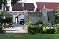
Röttingen city fortifications with Brattenstein Castle
The town fortifications of Röttingen were first mentioned in 1275. From this early period, some northern wall sections and the Jakobstor are still preserved. In the 2nd and 3rd third of the 14th century, the Berings was expanded on the north, east and south sides. After 1438, the Bering was expanded to the south-west, including Brattenstein Castle and the hospital. The moat on the south side has been preserved and is used as a mill moat. The trench is partially piped on the west and north sides, filled in on the north side and replaced by the railway line. The wall and towers are all built from shell limestone. Of the former 14 towers and three gate towers, five and two gate towers have been preserved. Starting at the Old Hundheim Tower in the southwest, the following components of the city fortifications are present in a clockwise direction. File number: D-6-79-182-2.
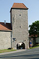
- Hauptstraße 2 ( location ): Old Hundheimer Turm, former gate tower, rectangular tower with a half-hipped roof and half-timbered gable, connected to the Hundheimer gate tower by a battlement path (D-6-79-182-2)
- Hauptstraße 2 ( location ): Hundheimer Torurm or Neutor, gate tower, rectangular, four-story solid building with half-timbered upper floor and bay window, 2nd half of the 15th century, as well as a mansard hipped roof, 18th century (D-6-79-182-13)
- Bad Mergentheimer Straße 2, on the property boundary ( location ): city wall, 14./15. Century (D-6-79-182-2)
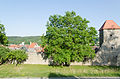
- Lagerweg 2: Brattenstein Castle , square complex , formerly the seat of the Lords of Hohenlohe , first mentioned in 1230, owned by the Würzburg monastery since 1345, seat of the prince-bishop's magistrate in the 16th century, rent office in the 19th century, today open-air theater and museum (D- 6-79-182-23)
- Lagerweg 2 ( location ): Brattenstein Castle , west wing, three-storey masonry building with half-hipped roof and half-timbered gable, 13th century core, heavily changed in 17th and 19th centuries (D-6-79-182-23)
- Lagerweg 2 ( location ): Brattenstein Castle , east wing, formerly tithe barn, three-storey stone masonry building with gable roof, 13th century core, remodeled in 17th and 19th centuries, partial collapse, 1971 (D-6-79-182-23)
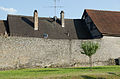
- Herrnstrasse 1, at the rear property boundary ( location ): city wall, 14./15. Century (D-6-79-182-2)
- Herrnstrasse 11, on the rear property boundary ( location ): city wall, 14th / 15th centuries. Century (D-6-79-182-27)
- Herrnstrasse 13, on the rear property boundary ( location ): city wall, 14th / 15th centuries. Century (D-6-79-182-2)
- Herrnstrasse 15, at the rear property boundary ( location ): city wall, 14./15. Century (D-6-79-182-2)
- Herrnstrasse 17, on the rear property boundary ( location ): city wall, 14th / 15th centuries. Century (D-6-79-182-29)
- Herrnstraße 19, on the rear property boundary ( location ): city wall, 14th / 15th centuries. Century (D-6-79-182-30)
- Obergasse 3, at the rear property boundary ( location ): city wall, 14./15. Century (D-6-79-182-2)
- Obergasse 5, on the rear property boundary ( location ): So-called swineherd tower, rectangular tower with hipped roof, 14th century (D-6-79-182-2)
- Obergasse 7, at the rear property boundary ( location ): city wall, 14./15. Century (D-6-79-182-2)
- Obergasse 9, at the rear property boundary ( location ): city wall, 14./15. Century (D-6-79-182-2)
- Obergasse 11, 13, 15, at the rear property boundary ( location ): city wall, 14./15. Century (D-6-79-182-2)
- Obergasse 17, at the rear property boundary ( location ): city wall, 14./15. Century (D-6-79-182-2)
- Erbsengasse 1, on the rear property boundary ( location ): city wall, 14./15. Century (D-6-79-182-2)

Alter Hundheimer Turm
more pictures
Old Hundheimer Tower and Hundheimer Gate Tower

Alter Hundheimer Turm
more pictures
Hundheim Gate Tower, city side
more pictures
Hundheim gate tower, field side
more pictures
Brattenstein Castle from the northeast with walls
more images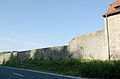
City wall at Herrenstrasse 1

City wall between Herrenstrasse 11 and 1

City wall at Herrenstrasse 11

City wall at Herrenstrasse 13

City wall at Herrenstrasse 15

City wall at Herrenstrasse 17
City wall at Herrenstrasse 19
City wall at Obergasse 3

Square tower at Obergasse 5
City wall at Obergasse 7

City wall at Obergasse 9

City wall at Obergasse 11, 13, 15

City wall at Obergasse 17


- Erbsengasse 3 ( location ): Gate tower, so-called Jakobstor, rectangular solid building with hipped roof, stone house and humpback cuboid, south side half-timbered, 13th / 14th century (D-6-79-182-1)
- Erbsengasse 5, on the rear property boundary ( location ): city wall, 14./15. Century (D-6-79-182-2)
- Erbsengasse 6, on the rear property boundary ( location ): city wall, 14./15. Century (D-6-79-182-2)
- Erbsengasse 7, on the rear property boundary ( location ): city wall, 14./15. Century (D-6-79-182-2)
- Erbsengasse 9, at the rear property boundary ( location ): city wall, 14./15. Century (D-6-79-182-2)
- Erbsengasse 9 ( location ): So-called snail tower, semicircular with a conical roof, 14th century (D-6-79-182-2)
- Erbsengasse 11, on the eastern edge of the road ( location ): city wall, 14./15. Century (D-6-79-182-2)
- Erbsengasse 12, on the eastern side of the road ( location ): city wall, 14./15. Century (D-6-79-182-2)
- Erbsengasse 14, at the property boundary ( location ): city wall, 14./15. Century (D-6-79-182-2)
- Erbsengasse 16 ( location ): So-called Rippacher tower, semicircular, with a slightly cantilevered upper floor and conical roof, 14th century (D-6-79-182-2)
- Obergasse 31, at the property boundary ( location ): city wall, 14./15. Century (D-6-79-182-2)
- Obergasse 33, at the property boundary ( location ): city wall, 14./15. Century (D-6-79-182-64)
- Obergasse 35, at the property boundary ( location ): city wall, 14./15. Century (D-6-79-182-2)
- Obergasse 37, at the property boundary ( location ): city wall, 14./15. Century (D-6-79-182-2)
- Hauptstraße 31, at the property boundary ( location ): city wall, 14./15. Century (D-6-79-182-2)
Jakobstor, field side
more pictures
Jakobstor, city side
more pictures
City wall at Erbsengasse 5

City wall at 6 Erbsengasse
City wall at Erbsengasse 7

City wall at 8 Erbsengasse

City wall at 9 Erbsengasse with a screw tower

Snail tower
more pictures
Rippacher Turm
more pictures
City wall at Obergasse 31

City wall at Obergasse 33

City wall at Hauptstrasse 31


The gate in the main street has come off. The city wall runs south of the main street as follows:
- Hauptstraße 28, at the property boundary ( location ): city wall, 14./15. Century (D-6-79-182-2)
- Untergasse 3, 5, 7, at the property boundary ( location ): city wall, 14./15. Century (D-6-79-182-2)
- Untergasse 9, 11, 15, 17, 19, at the property boundary ( location ): city wall, 14./15. Century (D-6-79-182-2)
- Wall between Untergasse and 23 removed
- Untergasse 23, 25, 27, at the property boundary ( location ): city wall, 14./15. Century (D-6-79-182-2)
- Untergasse 29, at the property boundary ( location ): city wall, 14./15. Century (D-6-79-182-2)
- Untergasse 31, at the property boundary ( location ): city wall, 14./15. Century (D-6-79-182-2)
- Untergasse 33, at the property boundary ( location ): city wall, 14./15. Century (D-6-79-182-2)
- Untergasse 35, 37, at the property boundary ( location ): city wall, 14./15. Century (D-6-79-182-2)
- Untergasse 39, on the property boundary ( location ): So-called mill tower, round tower with conical roof, 14th century (D-6-79-182-2)
- Hauptstraße 4, at the property boundary ( location ): city wall, 15th century (D-6-79-182-2)
- Hauptstraße 3, at the property boundary ( location ): city wall, 15th century (D-6-79-182-2)

City wall at Untergasse 23
City wall at Untergasse 31

Mill tower
more pictures


Architectural monuments according to districts
Röttingen
| location | object | description | File no. | image |
|---|---|---|---|---|
| Am Kapellenberg, Akazienweg, Akazienweg 1, Steig, Trieb ( location ) |
Way of the Cross | 13 stations, cast iron reliefs, neo-Gothic, around 1880/90, with a life-size Christ on the Mount of Olives as the prelude to the Way of the Cross, sandstone, 19th century. | D-6-79-182-90 | |
| At the Mühlbach, at the Tauberbrücke ( location ) |
Wayside shrine | Figure of Maria Immaculata on round column above pedestal with inscription field, sandstone, marked 1759 | D-6-79-182-81 |
 more pictures |
| Am Mühlbach ( location ) |
Former granulator | Two-storey quarry stone building with half-hipped mansard roof and ramp bridge to the upper floor, marked 1838 | D-6-79-182-135 |
 more pictures |
| At the Müllersweg ( us ) |
Wayside shrine | Shaft and base 1725, relief with a good shepherd 20th century
not re-qualified, not mapped in the Bavarian Monument Atlas |
D-6-79-182-121 | |
| Apothekengäßlein 1 ( location ) |
Residential buildings | Two-storey, plastered gable roof building, upper floor half-timbered, marked by an inscription stone of a former gate 1617 | D-6-79-182-3 |
 more pictures |
| Apothekengäßlein 2 ( location ) |
Former residential building | Two-storey, plastered gable roof building, upper floor plastered half-timbering, with Pietà relief as a house figure, 18th century | D-6-79-182-4 |
 more pictures |
| Bad Mergentheimer Straße 6 ( location ) |
crucifix | Cross on a bulged pedestal, corpus missing, 18./19. century | D-6-79-182-79 |
 more pictures |
| Bad Mergentheimer Straße 7 ( location ) |
Former gardener's house | single-storey, plastered mansard hipped roof, 18th century | D-6-79-182-6 | |
| Bad Mergentheimer Straße 7 ( location ) |
Enclosure of the former nursery | Haustein, 18th / 19th century | D-6-79-182-6 | |
| Near Bad Mergentheimer Straße, approx. 240 m west of the Neumühle ( location ) |
Wayside shrine | Relief attachment depicting the Trinity and crowning the cross, on a pillar above a pedestal, sandstone, marked 1756 | D-6-79-182-83 | |
| Benefiziumsgäßlein 8 ( location ) |
Residential buildings | Two-storey, plastered gable roof building, upper floor plastered timber frame, baroque, marked 1795 | D-6-79-182-7 |
 more pictures |
| Festplatz 1 ( location ) |
House Madonna | Wood, 18th century | D-6-79-182-12 | |
| Gaubahn hiking trail, road to Tauberrettersheim ( ) |
Wayside shrine | with fourteen helpers
not re-qualified, not mapped in the Bavarian Monument Atlas |
D-6-79-182-89 |
Former hospital, building complex from the early 17th century above the high medieval core:
| location | object | description | File no. | image |
|---|---|---|---|---|
| Hauptstrasse 4 ( location ) |
Former St. Peter and Paul Hospital Church | Hall building with retracted choir and roof turret with pointed helmet, Julius style, 1613–1615; with equipment | D-6-79-182-15 |
 more pictures |
| Hauptstrasse 4 ( location ) |
Former hospital building | Two-storey, plastered solid building with a gable roof, as well as eastern volute and western stepped gables, Julius style, marked 1613 | D-6-79-182-15 |
 more pictures |
| Hauptstrasse 4 ( location ) |
garden | with garden wall and outbuilding | D-6-79-182-15 |
 more pictures |
| location | object | description | File no. | image |
|---|---|---|---|---|
| Hauptstrasse 9 ( location ) |
House figure | Maria Immaculata, wood, 18th century | D-6-79-182-16 | |
| Hauptstrasse 19 ( location ) |
Formerly girls' school house | three-storey saddle roof building, upper floor half-timbered, marked 1821 | D-6-79-182-17 |
 more pictures |
| Hauptstrasse 20 ( location ) |
Gasthaus, so-called Gasthaus zum Kreuz | L-shaped, two-storey building complex with saddle roofs, upper floors half-timbered, eastern building 17th / 18th century, western extension with gate passage, 18th / early 19th century | D-6-79-182-18 |
 more pictures |
| Hauptstrasse 20 ( location ) |
Tavern boom | Wrought iron, around 1800 | D-6-79-182-18 |
 more pictures |
| Hauptstrasse 35 ( location ) |
Cemetery chapel | Catholic Chapel St. Georg, hall building, rectangular solid building with saddle roof and roof turret, 1588–1595; with equipment | D-6-79-182-22 |
 more pictures |
| Herrnstrasse 3 ( location ) |
Residential buildings | two-storey, plastered saddle roof building, upper floor half-timbered, 17th century | D-6-79-182-25 | |
| Herrnstrasse 4 ( location ) |
Gabled house | Former stable house, two-story, plastered saddle roof building, upper floor plastered half-timbering, with drilled window frames, 1614, overmolding, 18th century | D-6-79-182-26 |
 more pictures |
| Herrnstrasse 11 ( location ) |
Residential buildings | two-storey half-timbered building with a gable roof over a high base, 17th century | D-6-79-182-27 |
 more pictures |
| Herrnstrasse 17 ( location ) |
Former rectory | two-storey saddle roof construction, upper floor half-timbered, with two-storey wing with half-timbered upper storey attached to the south | D-6-79-182-29 |
 more pictures |
| Herrnstrasse 17 ( location ) |
Coat of arms stone | inscribed 1690, 16./17. century | D-6-79-182-29 | |
| Herrnstrasse 19 ( location ) |
Formerly a school | two-storey, plastered solid building with a flat hipped roof with sandstone structure, late classicistic, marked 1873 | D-6-79-182-30 |
 more pictures |
| Herrnstrasse 20 ( location ) |
Residential building and inn, built in 1740 (former post office) | Two-storey, plastered gable roof building, upper floor plastered half-timbering, with drilled window frames | D-6-79-182-31 |
![Residential building and inn, built in 1740 (former post office) [1]](https://de.wikipedia.org/wiki/Datei:R%C3%B6ttingen,_Obergasse_20_20170716_001.jpg) more pictures |
| Herrnstrasse 20 ( location ) |
House figure | Pietà, 18th century | D-6-79-182-31 |
 more pictures |
| Hofsteig, road to Würzburg ( ) |
crucifix | inscribed 1807
not re-qualified, not mapped in the Bavarian Monument Atlas |
D-6-79-182-95 | |
| Käppele ( location ) |
Chapel furnishings | the Catholic Marienkapelle of the previous building from 1864, im
New building from 1978/79 erected |
D-6-79-182-98 |

|
| Käppele ( location ) |
Wayside shrine | Mololite, relief attachment with depiction of the Madonna and crooked roof on pillars, in memory of the missing persons of the Second World War, by J. Stauder, 1950 | D-6-79-182-128 | |
| Kirchgasse 9 ( location ) |
House Madonna | Wood, 17th century | D-6-79-182-37 | |
| Kirchgasse 10 ( location ) |
House Madonna | 17./18. century | D-6-79-182-36 | |
| Kirchplatz 7 ( location ) |
Catholic parish church of St. Kilian | Hall building with retracted choir and eastern choir tower with pointed helmet, in the core late Romanesque, mid-13th century, choir extensions 14th and 15th centuries, redesign 1606–1614; with equipment | D-6-79-182-33 |
 more pictures |
| Kirchplatz 7 ( location ) |
Mount of Olives Chapel | with larger-than-life figures, sandstone, 18th century | D-6-79-182-33 | |
| Kirchplatz 7, on the south side of the church ( location ) |
Wayside shrine | Figure of the cruiser with thief on a pillar, sandstone, 1740 | D-6-79-182-33 |
 more pictures |
| Kirchplatz 7, on the south side of the church ( location ) |
Six epitaphs | embedded in the church wall, sandstone, 16./17. century | D-6-79-182-33 |
 more pictures |
| Kirchplatz 7 ( location ) |
Catholic Chapel of St. Elisabeth | former Karner, barrel-vaulted solid building with gable roof, 13th century; with equipment | D-6-79-182-34 |
 more pictures |
| Kirchplatz 8 ( location ) |
Residential buildings | single-storey, plastered half-timbered building with a saddle roof over a solid base, 18th century | D-6-79-182-32 | |
| Kirchplatz 19 ( location ) |
Courtyard | Residential building, two-storey, plastered saddle roof construction, upper floor half-timbered, with cellar exit and coat of arms stone, this marked. 1622, 17th century | D-6-79-182-35 | |
| Kirchplatz 19 ( location ) |
Courtyard | Barn, gable roof with half-timbered upper storey, marked 1783 | D-6-79-182-35 | |
| Kirchplatz 19 ( location ) |
Courtyard | Stable, two-storey solid building with a gable roof, stone and brick, in the core 18th century, renovation using older components, marked 1914. | D-6-79-182-35 | |
| Near Klingener Straße, at the Tauberbrücke (south bank) ( location ) |
Wayside shrine | Figure of the Scourge Christ on a renewed pillar above a pedestal, baroque, mid-18th century | D-6-79-182-85 |
 more pictures |
| Lagerweg 1 ( location ) |
Coat of arms stone | 1677
not re-qualified, not mapped in the Bavarian Monument Viewer |
D-6-79-182-38 | |
| Long belt, on the road to Giebelstadt, approx. 3.5 km outside ( ) |
Wayside shrine | with Madonna relief, 1st half of the 20th century
not re-qualified, not mapped in the Bavarian Monument Atlas |
D-6-79-182-97 | |
| Laudenbacher Steig ( location ) |
crossroads | Crucifix on pedestal, body heavily weathered, sandstone, probably 18th century | D-6-79-182-86 | |
| Lehmgrube, Ritzberg ( location ) |
Wayside shrine | Essay with a relief of the Sacred Heart, on a pillar above a pedestal, around 1920 | D-6-79-182-93 | |
| Marketplace 1 ( location ) |
town hall | three-storey solid building with hipped mansard roof, bell tower, house structure, drilled window frames and wrought-iron gargoyles, 1750 | D-6-79-182-39 |
 more pictures |
| Marketplace 2 ( location ) |
Residential buildings | Two-storey, gable-independent gable roof building, upper storey with ornamental framework and figural carving, marked 1729 | D-6-79-182-40 |
 more pictures |
| Marketplace 3 ( location ) |
Residential buildings | two-storey saddle roof building with half-timbered upper storey, in the core 16./17. century | D-6-79-182-41 |
 more pictures |
| Marketplace 3 ( location ) |
barn | Half-timbered building with saddle roof, in the core probably 17th / 18th centuries century | D-6-79-182-41 | |
| Marketplace 5 ( location ) |
Residential buildings | two-storey, plastered gable roof building, upper floor half-timbered | D-6-79-182-43 |
 more pictures |
| Marketplace 5 ( location ) |
House figure | Maria Immaculatà, wood, 18th century, 17th century | D-6-79-182-43 | |
| Marktplatz 6 ( location ) |
Building group consisting of an inn and a residential building | Eastern inn “Zum Ochsen”, two-storey, plastered saddle roof building with late classicist sandstone structure, mid-19th century | D-6-79-182-44 |
 more pictures |
| Marktplatz 6 ( location ) |
Building group consisting of an inn and a residential building | Western residential building, two-storey saddle roof building with half-timbered upper storey and dwarf house, using components from the former 17th century gable-front building, reorientation to the eaves side building, 1st quarter of the 19th century | D-6-79-182-44 |
 more pictures |
| Marketplace 7 ( location ) |
Residential buildings | two-storey, gable-independent gable roof building, upper storey ornamental framework, cantilevered on the west side, 17th century | D-6-79-182-45 |
 more pictures |
| Marktplatz 8 ( location ) |
Residential buildings | two-storey, gable-independent gable roof construction, upper storey ornamental framework, 17th / 18th century century | D-6-79-182-46 |
 more pictures |
| Marktplatz 9 ( location ) |
House Madonna | Wood, 17th / 18th centuries century | D-6-79-182-47 |
 more pictures |
| Marketplace 10 ( location ) |
Former pharmacy | Two-storey, plastered half-hipped roof building in corner position, upper floor half-timbered, around 1800 | D-6-79-182-48 |
 more pictures |
| Marktplatz 13 ( location ) |
Residential buildings | Two-storey eaves side building with saddle roof, half-timbered upper storey and drilled window frames, 18th century | D-6-79-182-50 |
 more pictures |
| Marktplatz 15 ( location ) |
Residential buildings | two-storey, plastered eaves side building with saddle roof, upper floor plastered timber frame, drilled window frames, 18th century | D-6-79-182-51 |
 more pictures |
| Neubronner Strasse ( location ) |
Wayside shrine | Canopy-like relief attachment with a Pietà and a cross crown, on a pillar over a bulged base, sandstone, inscribed 1810 | D-6-79-182-84 | |
| Obergasse 2 ( location ) |
Residential buildings | two-storey saddle roof building, upper storey ornamental framework, 17th century | D-6-79-182-52 |
 more pictures |
| Obergasse 10 ( location ) |
Residential buildings | single-storey, plastered half-timbered building over a massive basement, 17th / 18th centuries century | D-6-79-182-56 |
 more pictures |
| Obergasse 16 ( location ) |
Courtyard | Residential building, two-story saddle roof construction over a solid basement base, plastered half-timbering, 18th century | D-6-79-182-58 |
 more pictures |
| Obergasse 16 ( location ) |
Courtyard | Barn, plastered half-timbered building with saddle roof and cantilevered upper floor, ground floor partially petrified, in the core probably at the same time | D-6-79-182-58 |
 more pictures |
| Obergasse 18 ( location ) |
Residential buildings | two-storey saddle roof tree, upper storey ornamental framework, 17th century | D-6-79-182-60 |
 more pictures |
| Obergasse 19 ( location ) |
Basement exit | rounded, marked 1775 | D-6-79-182-61 |
 more pictures |
| Obergasse 21 ( location ) |
Gabled house | single storey over basement plinth, plastered half-timbering, 17th / 18th centuries century | D-6-79-182-62 |
 more pictures |
| Obergasse 33 ( location ) |
Former manor, former Freihof of the Lords of Würtzburg | Residential building, two-storey, plastered solid construction with half-hipped roof and drilled window frames, 1733 | D-6-79-182-64 |
 more pictures |
| Obergasse 33 ( location ) |
Former manor, former Freihof of the Lords of Würtzburg | Former outbuilding, built above the historical basement, with coat of arms stone | D-6-79-182-64 | |
| Obergasse 33 ( location ) |
Former manor, former Freihof of the Lords of Würtzburg | Courtyard gate, 18th century | D-6-79-182-64 | |
| State road 2268, direction Rothenburg, approx. 2 km outside ( location ) |
Wayside shrine | Relief attachment depicting the Christ child in the midst of the 14th helpers in need, on pillar above pedestal, sandstone, 18th century | D-6-79-182-88 | |
| State road 2268, to Giebelstadt at a small bridge approx. 2 km outside ( location ) |
Wayside shrine | Relief attachment with the coronation of Mary and canopy-like crowning, on a pillar, above a bulged pedestal, sandstone, 2nd half of the 18th century | D-6-79-182-94 | |
| Staatsstraße 2268, to Giebelstadt, approx. 300 m outside ( location ) |
crossroads | Crucifix on pedestal with inscription field, sandstone, inscribed 1817 | D-6-79-182-92 | |
| Stadtmühlgäßlein 3 ( location ) |
Residential buildings | two-storey, plastered half-timbered building over a raised base with a gable roof, upper storey with drilled window frames, 18th century, northern commercial extension 18th / 19th century. century | D-6-79-182-66 |
 more pictures |
| Taubergasse 5 ( location ) |
Residential buildings | three-storey, plastered gable roof building with gate passage, upper floor plastered half-timbering | D-6-79-182-67 |
 more pictures |
| Taubergasse 5 ( location ) |
House Madonna | 17./18. century | D-6-79-182-67 | |
| Taubergasse 6; Corner of Untergasse ( location ) |
Wayside shrine | Relief attachment depicting Pietà on a pillar, in baroque design, 1st quarter of the 20th century | D-6-79-182-69 |
 more pictures |
| Taubergasse 9 ( location ) |
Residential buildings | two-storey, plastered gable roof building with drilled window frames, baroque, marked 1792 | D-6-79-182-68 |
 more pictures |
| Tauberrettersheimer Straße ( ) |
Wayside shrine | with trinity
not re-qualified, not mapped in the Bavarian Monument Atlas |
D-6-79-182-82 | |
| Untergasse 8 ( location ) |
Former manorial residential building | So-called high building, tower-like, four-storey quarry stone building with half-timbered upper floor and gable roof, stone construction 13th century, half-timbered construction, 15th century | D-6-79-182-71 |
 more pictures |
| Werrgäßlein 5 ( location ) |
Residential buildings | Two-story saddle roof building, upper floor with ornamental framework, ground floor massive underpinned, marked 1579 | D-6-79-182-76 | |
| Werrgäßlein 5 ( location ) |
House Madonna | neo-gothic | D-6-79-182-76 | |
| Würzburger Strasse 3 ( location ) |
Wayside shrine | Relief attachment depicting the crucifixion and crowning of the cross, on a square pillar, sandstone, inscribed 1609 | D-6-79-182-78 |
 more pictures |
| Near Würzburger Straße ( location ) |
crossroads | Crucifix on pedestal with inscription, in front of it figure of the painful Mother of God, sandstone, 2nd half. 19th century | D-6-79-182-91 | |
| Near Würzburger Strasse; Near main street ( location ) |
graveyard | Walled complex with grave monuments from the early 20th century, laid out on the former ramparts on the north side of the city fortifications, today bounded to the west by city walls, 14th / 15th centuries. Century, with southern core area and northern extension with cemetery wall, Haustein, 19th century | D-6-79-182-21 | |
| Near Würzburger Straße ( location ) |
Cemetery cross | Crucifix on pedestal with inscription, sandstone corpus based on an older model, around 1920 | D-6-79-182-21 |
 more pictures |
| Near Würzburger Strasse; Near main street ( location ) |
Way of the Cross | 14 stations, construction with sandstone reliefs and cast iron crowning, above a pedestal, around the middle of the 19th century | D-6-79-182-21 |
 more pictures |
| Near Würzburger Strasse; Near main street ( location ) |
graveyard | Funerary monuments, 19th and 20th centuries | D-6-79-182-21 | |
| Grünsfeld (in the Eichelsee corridor department) ( location ) |
Wayside shrine | Relief attachment with the coronation of the Virgin Mary and canopy-like crowning, on a pillar above a bulged pedestal, sandstone, 18th century | D-6-79-182-99 | |
| Lindenweg (on Aubergweg) ( location ) |
Wayside shrine | Essay with trinity relief and crowning of the cross, on pillar above pedestal, sandstone, inscribed 1739 | D-6-79-182-127 | |
| Mühlweg (on Rothenburger Straße, approx. 2 km outside) ( location ) |
Wayside shrine | Essay with cross crown and Madonna relief, on pillar above pedestal, monolithic, sandstone, 1920 | D-6-79-182-87 | |
| St 2268 (on the road to Giebelstadt, approx. 3 km outside) ( location ) |
Wayside shrine | Fiale-crowned relief essay with Lucanian consolation, on pillar above pedestal, sandstone, 1882 | D-6-79-182-96 | |
| Pilste (on Niederrimbacher Strasse) ( location ) |
Wayside shrine | Canopy-crowned relief attachment with the Holy Trinity and Pietà, on round column above pedestal, shaft renewed around 1900, sandstone, 18th century | D-6-79-182-126 |
Aufstetten
| location | object | description | File no. | image |
|---|---|---|---|---|
| Am Bieberehrener Weg ( location ) |
Wayside shrine | Relief attachment with depictions of the Holy Family, back Pietà, on pillar above pedestal, neo-Gothic, sandstone, inscribed 1856 | D-6-79-182-109 | |
| At the Gussgraben; on Gelchsheimer Weg next to an old tree ( location ) |
Wayside shrine | Fiale-crowned relief top with fourteen helpers and Pietà, on pillar above pedestal, neo-Gothic, sandstone, inscribed 1887 | D-6-79-182-104 | |
| Äussere Dorfstrasse 7 ( location ) |
Wayside shrine | Diamond-shaped attachment with a modern Madonna relief, on a pillar above a bulged pedestal, attachment possibly 19th century, sandstone, 1799 | D-6-79-182-110 | |
| Baldersheimer Straße, St 2269, approx. 600 m before the village on the right ( location ) |
Wayside shrine | Relief attachment with Madonna and Trinity, on a pillar above a bulged base, neo-Gothic, sandstone, 2nd half of the 19th century | D-6-79-182-103 | |
| Dorfstrasse 5 ( location ) |
Wayside shrine | Niche top with cross crown and relief of the Queen of Heaven, on pillar with figure of St. Joseph, neo-Gothic, sandstone, inscribed 1895 | D-6-79-182-102 | |
| Dorfstrasse 15, by the church ( location ) |
Wayside shrine | Essay with relief of the Trinity and crowning, on a pillar above a bulged pedestal, sandstone, inscribed 1774 | D-6-79-182-101 | |
| Dorfstrasse 15 ( location ) |
catholic parish church of St. John Baptista | Hall with retracted choir, roof turret, 1741; with equipment | D-6-79-182-100 | |
| Dorfstrasse 16 ( location ) |
Residential buildings | Two-storey half-hipped roof building with plastered half-timbered upper storey, the core from 1669 ( dendrochronologically dated ), remodeled in the 19th century, completely renovated in the 20th century | D-6-79-182-129 | |
| Near the cemetery ( location ) |
Wayside shrine | Monolith, niche top with Pietà relief and cross crowning, on a pillar in relief over a pedestal, sandstone, 1798 | D-6-79-182-108 | |
| Krautäcker ( location ) |
Wayside shrine | Niche top with crowned cross and figure of Maria Immaculatà, on pillar above the bulbous base, top and pillar marked 1901, base marked 1856 | D-6-79-182-105 | |
| Lenzenbrunner Weg, on a hill ( us ) |
Wayside shrine | Mary with Child and Trinity, inscribed 1893
not re-qualified, not mapped in the Bavarian Monument Atlas |
D-6-79-182-106 | |
| Obere Dorfstrasse 13 ( location ) |
House figure | Lourdes Madonna in a round niche with grotto fragments, mounted wooden sculpture, 1891 | D-6-79-182-130 | |
| Obere Haagäcker, behind the forest "Haagholz" at the beginning of a field ( location ) |
Wayside shrine | Essay with cross crown and Madonna relief, on pillar above pedestal, inscribed 1876 | D-6-79-182-107 | |
| Weidig, in the forest on Burgerrother Straße ( location ) |
Wayside shrine | Niche top on a bulged pillar above a pedestal, sandstone, marked 1760 | D-6-79-182-111 |
Strüth
| location | object | description | File no. | image |
|---|---|---|---|---|
| Brunnengasse 4 ( location ) |
Former rectory | two-storey, plastered solid building with a mansard hipped roof, above a high basement, baroque, 18th century | D-6-79-182-113 | |
| Brunnengasse ( location ) |
Wayside shrine | Canopy-crowned relief attachment with the coronation of Mary on a pillar with medallion reliefs, this 2nd half of the 18th century, above a pedestal, sandstone, inscribed 1713 | D-6-79-182-131 | |
| Eck, Kreisstraße WÜ 42 ( location ) |
Wayside shrine | Gable-roofed relief piece with crowning cross and bust of the Madonna, on pillar above pedestal, sandstone, 2nd half of the 19th century | D-6-79-182-122 | |
| Erzgärtenweg ( location ) |
Wayside shrine | Relief essay with crucifixion with donor family and crowning of the cross, on a pillar, sandstone, inscribed 1626 | D-6-79-182-120 | |
| Holzspitze, Schönstheimer Wald ( ) |
Wayside shrine | 1706
not re-qualified, not mapped in the Bavarian Monument Atlas |
D-6-79-182-124 | |
| Near Kreuzschleiferweg ( location ) |
Cross tug | Figure of Christ carrying the cross on his knees, above a pedestal, sandstone, inscribed 1813 | D-6-79-182-117 | |
| Oberhauser Strasse ( location ) |
Wayside shrine | Relief attachment with a canopy-like crown and depiction of a Pietà, on a pillar above a pedestal, sandstone, inscribed 1814 | D-6-79-182-132 | |
| St.-Nepomuk-Straße 9 ( location ) |
House figure | Sculpture of St. Joseph with the baby Jesus, mounted wood, 19th century | D-6-79-182-133 | |
| St.-Nepomuk-Straße 11 ( location ) |
Former stable house | Two-storey saddle roof building with half-timbered upper storey, above a high basement, with a figure of a Pietà, 1820 | D-6-79-182-115 | |
| St.-Nepomuk-Straße 13 ( ) |
Wayside shrine with Pietà relief | Mid 19th century
not re-qualified, not mapped in the Bavarian Monument Atlas |
D-6-79-182-114 | |
| St.-Nepomuk-Straße 13 ( location ) |
House Madonna | Wood, early 19th century | D-6-79-182-116 | |
| St.-Nepomuk-Straße 17 ( location ) |
Catholic parish church of St. Johannes Nepomuk | Hall building with retracted choir, hipped roof and ridge turret with bell roof, baroque, 1742; With
Furnishing |
D-6-79-182-112 | |
| Near St.-Nepomuk-Straße ( location ) |
Cemetery cross | Crucifix on a bulged pedestal, partially renewed, inscribed 1811 | D-6-79-182-118 | |
| Near St.-Nepomuk-Straße ( location ) |
Wayside shrine | Fial crowned relief piece with Madonna, reverse with crucifixion, on pillar above pedestal, neo-Gothic, sandstone, inscribed 1877 | D-6-79-182-119 | |
| Strüther Berg, approx. 1.4 km southeast of the village, around 1900 ( location ) |
Field chapel | small single storey solid building with gable roof | D-6-79-182-123 |
Former architectural monuments
This section lists objects that were previously entered in the list of monuments.
| location | object | description | File no. | image |
|---|---|---|---|---|
| Röttingen Kirchgasse 7 ( location ) |
Residential buildings | two-storey, plastered saddle roof building, upper floor half-timbered, 1453 (dendro.dat.) | D-6-79-182-125 | |
| Röttingen Rothenburger Straße 7, approx. 100 m outside the village ( ) |
Reliefs Crucifixion and Holy Bishop | marked 1463, renovated in 1642 | D-6-79-182-80 |
See also
Remarks
- ↑ This list may not correspond to the current status of the official list of monuments. The latter can be viewed on the Internet as a PDF using the link given under web links and is also mapped in the Bavarian Monument Atlas . Even these representations, although they are updated daily by the Bavarian State Office for Monument Preservation , do not always and everywhere reflect the current status. Therefore, the presence or absence of an object in this list or in the Bavarian Monument Atlas does not guarantee that it is currently a registered monument or not. The Bavarian List of Monuments is also an information directory. The monument property - and thus the legal protection - is defined in Art. 1 of the Bavarian Monument Protection Act (BayDSchG) and does not depend on the mapping in the monument atlas or the entry in the Bavarian monument list. Objects that are not listed in the Bavarian Monument List can also be monuments if they meet the criteria according to Art. 1 BayDSchG. Early involvement of the Bavarian State Office for Monument Preservation according to Art. 6 BayDSchG is therefore necessary in all projects.
literature
- Denis André Chevalley: Lower Franconia . Ed .: Michael Petzet , Bavarian State Office for the Preservation of Monuments (= Monuments in Bavaria . Volume VI ). Oldenbourg, Munich 1985, ISBN 3-486-52397-X .
Web links
- Bavarian Monument Atlas (cartographic representation of the Bavarian architectural and ground monuments by the Bavarian State Office for Monument Preservation (BLfD) )
- List of monuments for Röttingen (PDF) at the Bavarian State Office for Monument Preservation
Individual evidence

Altertheim | Aub | Bergtheim | Bieberehren | Bütthard | Eibelstadt | Eisenheim | Eisingen | Erlabrunn | Estenfeld | Frickenhausen am Main | Gaukönigshofen | Gelchsheim | Gerbrunn | Geroldshausen | Gable City | Greußenheim | Güntersleben | Hausen near Würzburg | Helmstadt | Hettstadt | Höchberg | Wooden churches | Kirchheim | Box | Small cattle field | Kürnach | Leinach | Margetshöchheim | Neubrunn | Oberpleichfeld | Ochsenfurt | Prosselsheim | Randersacker | Reichenberg | Remlingen | Riedenheim | Rimpar | Rottendorf | Röttingen | Sommerhausen | Sonderhofen | Tauberrettersheim | Theilheim | Thüngersheim | Uettingen | Unterpleichfeld | Veitshoechheim | Waldbrunn | Waldbüttelbrunn | Winterhausen | Zell am Main