
List of architectural monuments in Sommerhausen
On this page the monuments of the Lower Franconian market Sommerhausen are compiled. This table is a partial list of the list of architectural monuments in Bavaria . The basis is the Bavarian Monument List , which was first drawn up on the basis of the Bavarian Monument Protection Act of October 1, 1973 and has since been managed by the Bavarian State Office for Monument Preservation . The following information does not replace the legally binding information from the monument protection authority. This list reflects the update status of May 8, 2020 and contains 79 monuments.

Ensembles
Ensemble town center Sommerhausen
The market town of Sommerhausen ( Lage ) with its fortification wall from the late 15th / early 16th century and its river-side, partly landscaped grounds is closely connected to the opposite Winterhausen through the river crossing. In the course of the Middle Ages, Sommerhausen developed away from its original core, which is to be assumed around the church fortress of the Frauenkirche and today's Badgasse. In terms of its importance for the local topography, the initially predominant cross-river direction (Badgasse) was replaced by the Fernweg running parallel to the Main, which decisively determined the layout of the market place. As a broad main street, this runs through the town from gate to gate and divides it into a river-side and a mountain-side half. From this main axis branch off to both sides side streets, which are mostly arranged approximately at right angles. The main focus of the local structure is the parish church and the castle, both of which still form independent districts on the east side of the main street. A monk's courtyard in the south-western part of the town is no longer monumentally tangible and only passed down by the street name. As in other Main cities, the main road itself and the mountain-side half of the village are predominantly built on with wine farms, while smaller-scale buildings, originally boatmen, fishermen and craftsmen's properties, determine the river-side half of the village. The buildings still largely have the appearance of the 16th – 18th centuries. Century. The main street is characterized by several stately houses from the 17th and 18th centuries, according to its primary importance; However, the monumental buildings play a decisive role in the street scene: the narrow western side of the sober, classic church longhouse from the 18th century runs diagonally into the eastern street front, while the distinctive landmarks in the high-gabled quarry stone façades of the town hall and the castle building from the 16th century owns. The main road is closed at its ends by the main gates of the city fortifications. The side streets consist of smaller, sometimes irregular buildings that give the place its well-known picturesque character. A garden area with walls and gates from the 18th century extends across the broad bank in front of the city wall on the river side. The transition to the actual bank area is now cut off by the bypass road. Boundary: outer edge of Alte Brückenstraße, Malipiero-Platz, Ernst-Gebhard-Ring and Herrengasse, banks of the Main. File number: E-6-79-187-2.
Ensemble of local centers in Sommerhausen and Winterhausen
The ensemble ( location ) comprises two walled church villages facing each other on the Main , which have belonged together since the early Middle Ages and originally had the common name Ahusen. After several changes of ownership in the first half of the 15th century, they came from imperial estates to the Limpurg taverns in their legal successors, the Count Rechteren-Limpurg-Speckfeld, who remained in control of the two villages until 1803 with the curious summer houses War fell on Bavaria and was mediatized. In terms of their structural design, both villages are coordinated with one another, with the emphasis on Sommerhausen , which has better vineyards due to its southern slopes. This is where the Count's castle developed, the structural appearance of which was essentially built on the 15th and 16th centuries. Century. As early as 1300, both places had two churches each, one of which with a small fortification opposite one another on the Main, dedicated to Maria and Mauritius, and another one on the mountain side of the main street parallel to the Main, dedicated to Saints Bartholomew and Nicholas. Both churches on the side of the river are on the edges of the fortifications that were built in the 15th century. While the church in Sommerhausen was incorporated into the fortifications, in Winterhausen it remained outside, was profaned and is now a residential building. Both villages have the characteristic structure of the medieval Mainorte: mostly stately wineries on the mountain side of the main street parallel to the Main, with loosely built, large properties and stately buildings in the appearance of the 16th – 18th centuries. Century in a dominant position. On the river side, on the other hand, close together, in a system of narrow alleys, there are arable boatmen and fishermen's properties with small outbuildings, on the main street larger inns, hackers' and craftsmen's houses and the town hall. Both town halls were built around the middle or in the second half of the 16th century, but the winter houses were completely remodeled in the 18th century. Both places received in 15./16. Century fortifications with wall ring, wall towers, moat and three gates each. This fortification is better preserved in Sommerhausen, but also clearly recognizable in Winterhausen. Both places have main landings with inns at the Maintor, small river ports and stations for the Main shipping. The connection between the villages was made by a ferry for loads and a small, always ready boat for people. It was not until 1897 that a stone bridge with a customs house was built on the Winterhauser side, which was destroyed again in the Second World War and partly still stands as a ruin. Like this older bridge, the new bridge, built further downstream in 1969/70, is primarily used for regional traffic between Giebelstadt and Kitzingen. It limits the ensemble to the northwest. The bank situation on both banks of the Main, untouched except for inconspicuous regulatory structures, with the river-parallel former towpaths, the main inns and the dead branches of the Main overgrown with willow trees, was disturbed by the bypass road on the Sommerhauser side, which also severely impaired the cohesion of the two places. The summer house directly opposite, largely undeveloped land, also belongs to the ensemble. Boundary: (summer houses side) Neue Mainbrücke - beeline to Jahnstraße - Jahnstraße to the junction of the street to Erlach - street above the cemetery to the fortifications at the Blue Tower - fortifications from the Blue Tower to the Ochsenfurter Tor - space in front of the Ochsenfurter Tor - beeline to Main - (Winterhäuser side) - linear distance to the railway underpass of the road to Goßmannsdorf - course of the railway line to the underpass of Fuchstadter Straße - Fuchstadter Straße to the bridge approach of the new Main Bridge. File number: E-6-79-187-3.
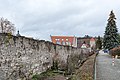
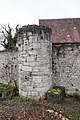
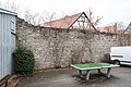
Fortification Sommerhausen
The fortification consists of an almost completely preserved high rectangular wall ring, some of which still rises up to seven meters. In the north-west corner it encompasses the old St. Mary's Church, now in ruins, in a bastion-like projection. The fortification has a total of three gate towers, the Würzburger Tor in the north (see Hauptstrasse 1), the Maintor in the west (see Ullrich-Gast-Weg 4) and the Ochsenfurter Tor in the south (see Hauptstrasse 46) and has three round shell towers or . Tower stumps eight, partly towering defense towers. The fortification wall was built as quarry stone masonry, the towers as outwardly trimmed ashlar masonry in the late 15th and first third of the 16th century and is labeled "1531". File number D-6-79-187-2.
Starting in the northwest, the following parts of the fortification have been preserved in a clockwise direction:
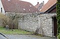
- Alte Brückenstraße 2 ( location ): Wall of the fortifications, 15./16. century
- Badgasse 3, 5, 7 ( location ): Wall of the former fortified church, medieval
- Badgasse 1 ( location ): churchyard fortifications, quarry stone masonry, partially built, later incorporated into the local wall
- Badgasse 9, on the northern property boundary ( location ): Wall of the fortifications, 15./16. century
- Alte Brückenstraße 4, on the northern property boundary ( location ): Wall of the fortifications, 15./16. century
- Badgasse 11, on the northern property boundary ( location ): Wall of the fortifications, 15./16. century
- Badgasse 13, on the northern property boundary ( location ): Wall of the fortifications, 15./16. century
- Badgasse 15, on the northern property boundary ( location ): Wall of the fortifications, 15./16. century
- Badgasse 17, 19, on the northern property boundary ( location ): Wall of the fortifications, 15./16. century
- Badgasse 21, 23, on the northern property border ( location ): Wall of the fortifications, 15./16. Century, partially replaced
- Hauptstraße 2, on the northern property boundary ( location ): Wall of the fortifications, 15./16. century
- Hauptstraße 2, on the northern property boundary ( location ): Wall of the fortifications, 15./16. century
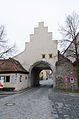
- Hauptstraße 1 ( location ): Würzburger Tor, gate tower, seat of the gate tower theater since 1950, solid construction with gate passage with stepped gable and gable roof as well as neighboring gatekeeper house, small solid building with hipped roof, 15th / 16th Century (D-6-79-187-29)

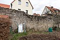
Alte Brückenstraße 2, wall of the former fortified church,
more pictures
Alte Brückenstraße 4, built-up wall section

Badgasse 11, built-in wall section
Badgasse 13, built-in wall section

Badgasse 17, built-in wall section
Badgasse 21, section of the wall with later installation of the gate
Würzburger Tor, field side
more pictures
Gatekeeper house of the Würzburg gate, field side
more pictures
Würzburger Tor, local site for
more pictures


- Katharinengasse 3, at the property boundary ( location ): Wall of the fortifications, 15./16. century
- Katharinengasse 5, at the property boundary ( location ): Wall of the fortifications, 15./16. century
- Malipieroplatz ( location ): fortification tower, semicircular shell tower stump, 15./16. century
- Katharinengasse 7, at the property boundary ( location ): Wall of the fortifications, 15./16. century
- Katharinengasse 9, at the property boundary ( location ): Wall of the fortifications, 15./16. century
- Katharinengasse 11, at the property boundary ( location ): Wall of the fortifications, 15./16. century
- Katharinengasse 13, 15, at the property boundary ( location ): Wall of the fortifications, 15./16. century
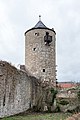
- Katharinengasse 17 ( location ): Blauer Turm, former defense or prison tower, round tower, four-storey solid building with conical roof, formerly with a square top, labeled "1513" and "1543"
- Ernst-Gebhardt-Ring, along the street ( location ): Wall of the fortifications, 15./16. century
- Am Berghof 7 ( location ): Flurer tower, former defense tower, rectangular tower, three-storey solid building with gable roof and northern porch, first quarter of the 16th century
- Ernst-Gebhardt-Ring, along the street ( location ): Wall of the fortifications, 15./16. century
- Am Berghof 13 ( location ): Red Tower, former defense tower, round tower, three-story solid building with a conical roof, first quarter of the 16th century
- Ernst-Gebhardt-Ring, along the street ( location ): Wall of the fortifications, 15./16. century
- Ernst-Gebhardt-Ring ( location ): Former defense tower, semicircular shell tower stump, 15./16. century
- Wall breakthrough on Rathausgasse
- Ernst-Gebhardt-Ring, along the street ( location ): Wall of the fortifications, 15./16. century
- Ernst-Gebhardt-Ring ( location ): Former defense tower, round tower, two-storey solid construction with pointed helmet, inscribed "1529"
- Ernst-Gebhardt-Ring, along the street ( location ): Wall of the fortifications, 15./16. century

Malipieorplatz, semicircular shell tower stump
more pictures
Malipieorplatz, semicircular shell tower stump
more pictures
Gate at Katharinengasse 17
Blue tower, more pictures from the east

Blue tower, field side, detail
further pictures
Blue tower, more pictures from the east

north of Am Berghof 7

Corridor tower, field side
more pictures
Corridor tower, field side, further pictures from the south

north of Am Berghof 13

Red tower, field side
more pictures
Red tower, field side, further pictures from the south

at Rathausgasse

Wall tower on Rathausgasse
more pictures
Wall tower on Rathausgasse
more pictures
Wall tower on Rathausgasse
more pictures
Wall move Ernst-Gebhardt-Ring, local side
Wall move Ernst-Gebhardt-Ring, field side
Wall move Ernst-Gebhardt-Ring, field side
Wall tower Ernst-Gebhardt-Ring, east of the castle
more pictures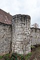
Wall tower Ernst-Gebhardt-Ring, east of the castle
more pictures
Wall tower Ernst-Gebhardt-Ring, east of the castle
more pictures
Wall move Ernst-Gebhardt-Ring, field side
Wall move Ernst-Gebhardt-Ring, field side


- Hauptstraße 46 ( location ): Ochsenfurter Tor, gate tower, three-story solid building with passage, hipped roof and bell tower, in the basement floors 15th and 16th. Century, upper floor with pilaster structure and roofing, 17th / 18th century. Century, with a gate keeper's house to the south, a small solid building with a hipped roof, 15th / 16th century. century
- Rumorknechtsweg, along the way ( location ): Wall of the fortifications, 15./16. century
- Rumorknechtsweg ( location ): fortification tower, stump of a semicircular shell tower, 15./16. century
- Rumorknechtsweg ( location ): gate, 18th century
- Rumorknechtsweg 2 ( location ): Rumorknechtsturm, former defense tower, round tower, three-storey solid construction with onion dome, first quarter of the 16th century
- Georg-Koberer-Weg 6, 8 ( location ): Wall of the fortifications on the back wall of the building, 15./16. century
- Georg-Koberer-Weg, along the way ( location ): Wall of the fortifications, 15./16. century
- Georg-Koberer-Weg 4 ( location ): Former defense tower, rectangular tower, three-storey saddle roof building with half-timbered upper storey, first quarter of the 16th century
- Ulrich-Gast-Weg 4 ( location ): Maintor, gate tower, three-story solid building with gate passage, half-hipped roof and high water marks, as well as gatekeeper's house to the west, small solid building with gable roof, 15th / 16th century
- Ulrich-Gast-Weg 2 ( location ): Former defense tower, rectangular tower, three-storey saddle roof building with half-timbered upper storey, labeled "1535"
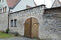
- Ulrich-Gast-Weg, at the exit of Badgasse ( location ): gate
- Ulrich-Gast-Weg 3 ( location ): Former defense tower, rectangular tower, three-story solid building with a gable roof and half-timbered upper floor, essentially the first quarter of the 16th century

Ochsenfurter Tor, field side
more pictures
Wall move Rumorknechtsweg

Wall move Rumorknechtsweg

Fortification tower Rumorknechtsweg
more pictures
Fortification tower Rumorknechtsweg
more pictures
Gate at Rumorknechtsturm
more pictures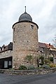
Rumorknechtsturm
more pictures
Wall at Georg-Koberer-Weg 8, field side
Local wall Georg-Koberer-Weg 6
Wall tower, Georg-Koberer-Weg 4
more pictures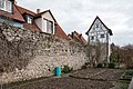
Wall tower, Georg-Koberer-Weg 4
more pictures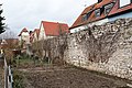
Ulrich-Gast-Weg between 2 and 4

Ulrich-Gast-Weg between 2 and 4
Ulrich-Gast-Weg between 2 and 4

Maintor, field side
more pictures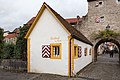
Maintor, gatekeeper house field side
more pictures
Maintor, high water marks
more pictures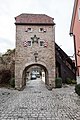
Maintor, local page
more pictures
Wall tower, Ulrich-Gast-Weg 2
more pictures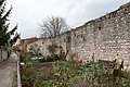
along Ulrich-Gast-Weg

Wall tower, Badgasse 3
more pictures
Wall tower, Badgasse 3
more pictures


Architectural monuments
| location | object | description | File no. | image |
|---|---|---|---|---|
| Am Berghof 1 ( location ) |
Residential buildings | Two-storey, plastered saddle roof building over basement, with half-timbered upper storey, roof hipped to the north, in the core 16./17. century | D-6-79-187-4 |
 more pictures |
| Am Berghof 8 ( location ) |
Courtyard | Two-storey, plastered gable roof building on a hook-shaped floor plan, the northern gable of the southern wing hipped, with drilled window and door frames, re. 1752 and 1753, installation of a leaf hut re. 1879 | D-6-79-187-102 |

|
| Am Berghof 8 ( location ) |
enclosure | Unplastered quarry stone wall, eastern courtyard with ball-crowned gate pillars, 18th century, western courtyard with arrow lattice gate, inscribed. 1888 | D-6-79-187-102 |
|
| Am Berghof 9 ( location ) |
Residential buildings | Two-storey, plastered gable roof building, 17th / 18th centuries century | D-6-79-187-6 |
 more pictures |
| Am Berghof 9 ( location ) |
barn | Quarry stone masonry construction with a gable roof, probably at the same time | D-6-79-187-6 |
|
| Am Berghof 16 ( location ) |
Residential buildings | Two-storey, plastered mansard roof building, probably with a half-timbered upper storey, essentially 18th century, modernized | D-6-79-187-7 |
|
| Badgasse 1 ( location ) |
Former Frauenkirche | Former fortified church, square tower with pyramid roof and nave ruins, Romanesque, around 1150 | D-6-79-187-8 |
 more pictures |
| Badgasse 1 ( location ) |
Cemetery fortifications | Quarry stone masonry, partially built, later included in the local wall, at the same time | D-6-79-187-8 |
 more pictures |
| Badgasse 2 ( location ) |
enclosure | Quarry stone garden wall and gate with drilled walls, inscribed "1734" | D-6-79-187-9 |
|
| Badgasse 8 ( location ) |
Residential buildings | Two-storey, plastered gable roof building, essentially 16th century, modernized | D-6-79-187-11 |
 more pictures |
| Badgasse 10 ( location ) |
Former residential building | Two-storey, plastered saddle roof building, with half-timbered upper storey, in the core of the 16th century | D-6-79-187-13 |
 more pictures |
| Badgasse 12 ( location ) |
Residential buildings | Two-storey, plastered saddle roof building with half-timbered upper storey and gate passage, the core of the 16th century | D-6-79-187-99 |
 more pictures |
| Badgasse 14 ( location ) |
Residential buildings | Two-storey, plastered saddle roof construction with gate passage and drilled window frames, with associated service wing, marked “1592” in the core, remodeling 18th century | D-6-79-187-17 |
 more pictures |
| Badgasse 16 ( location ) |
Former residential building | Two-storey, plastered gable roof building, door jambs marked "1591", modern overformed | D-6-79-187-19 |
 more pictures |
| Badgasse 16 ( location ) |
barn | Half-timbered building, 17th century | D-6-79-187-19 |
|
| Badgasse 20 ( location ) |
Residential buildings | Two-storey, plastered saddle roof building with half-timbered upper storey, 18th / 19th centuries century | D-6-79-187-21 |
|
| Casparigasse 4 ( location ) |
Former synagogue, since 1953 Catholic chapel | Plastered solid building with hipped roof and arched windows, with an eastern, two-storey residential part, 1819 | D-6-79-187-98 |
|
| Casparigasse 20 ( location ) |
Residential buildings | Two-storey, plastered gable roof building with half-timbered upper storey, mid-19th century | D-6-79-187-23 |
|
| Tännig, in a vineyard east of the village ( location ) |
Memorial cross | Crucifix on a stepped pedestal with inscription, sandstone, around 1920 | D-6-79-187-97 |
|
| Hauptstrasse 2 ( location ) |
Residential buildings | Two-storey, elongated saddle-roof building with a rich half-timbered upper storey from the 17th century, with an adjoining two-storey rear building with half-timbered upper storey, gate walls of the main building marked "1738" | D-6-79-187-30 |
 more pictures |
| Hauptstrasse 5 ( location ) |
Residential buildings | Two-storey, plastered gable roof building in corner position, with half-timbered upper floor and south adjoining, two-story auxiliary building with half-timbered upper floor and saddle roof, 16th-18th centuries. century | D-6-79-187-31 |
 more pictures |
| Hauptstrasse 6 ( location ) |
Residential buildings | Two-story, plastered saddle roof building with half-timbered upper floor, in the core 17th / 18th century. century | D-6-79-187-32 |
|
| Hauptstrasse 7 ( location ) |
Former residential building | Two-storey, plastered cripple-hip roof building with gate passage, mid-19th century | D-6-79-187-33 |
|
| Hauptstrasse 8 ( location ) |
Former inn | Two-storey hipped mansard roof with drilled window frames, western extension and cantilever, 18th century | D-6-79-187-34 |
 more pictures |
| Hauptstrasse 9 ( location ) |
Residential buildings | Two-storey, plastered hipped roof building in corner position, with half-timbered upper storey and northern extension with saddle roof, 18th century | D-6-79-187-35 |
|
| Hauptstrasse 10 ( location ) |
Residential buildings | Two-storey, plastered solid building with a gable roof, first half of the 19th century over an older core, renewed | D-6-79-187-36 |
 more pictures |
| Hauptstrasse 10 ( location ) |
Courtyard gate system | Gate with stilted profile, 17th century, gate pillar first half of the 19th century | D-6-79-187-36 |
 more pictures |
| Hauptstrasse 10 ( location ) |
Outbuildings | Solid construction with saddle roof and half-timbered gable as well as eastern porch, probably 18th / early 19th century | D-6-79-187-36 |
more pictures |
| Hauptstrasse 12 ( location ) |
Residential buildings | Two-storey half-hipped roof building with plastered half-timbered upper storey, gable with rich ornamental framework, 17th century, ground floor with structures from the 18th century | D-6-79-187-37 |
 more pictures |
| Hauptstrasse 13 ( location ) |
Residential buildings | Two-storey, plastered gable roof building with timber-framed upper storey protruding over stone consoles, 16./17. Century, two-storey rear building with a gable roof, re. 1589, in the core probably 15th century, early baroque stucco ceilings around 1700 | D-6-79-187-38 |
 more pictures |
| Hauptstrasse 13 ( location ) |
Vaulted cellar | re. 1687, integrated into the rear barn | D-6-79-187-38 | |
| Hauptstrasse 13 ( location ) |
Courtyard gate | Probably at the same time | D-6-79-187-38 |
 more pictures |
| Hauptstrasse 14 ( location ) |
Residential buildings | Two-storey, plastered hipped roof building, partly with a half-timbered upper storey, with drilled window frames, second half of the 18th century | D-6-79-187-39 |
 more pictures |
| Hauptstrasse 15 ( location ) |
town hall | Two-storey, massive quarry stone masonry building with a gable roof and stepped gable, inscribed "1558"; with equipment | D-6-79-187-40 |
 more pictures |
| Hauptstrasse 16 ( location ) |
Residential buildings | Single-storey solid building with mansard gable roof, half-timbered gable and gate passage, marked "1604" | D-6-79-187-41 |
 more pictures |
| Hauptstrasse 19 ( location ) |
Residential buildings | Two-storey mansard gable roof building with half-timbered upper storey, labeled "1565" | D-6-79-187-42 |
 more pictures |
| Hauptstrasse 22 ( location ) |
Former barn | Two-storey saddle roof building with half-timbered upper storey, ground floor modernly remodeled, 16./17. century | D-6-79-187-43 |
 more pictures |
| Hauptstrasse 23 ( location ) |
Residential buildings | Two-storey, plastered hipped roof building, probably with a half-timbered upper storey, second half of the 18th century | D-6-79-187-44 |
 more pictures |
| Hauptstrasse 24 ( location ) |
The Golden Ox Inn | Two-storey quarry stone masonry building with hipped roof and traditional pub cantilever, mid-19th century | D-6-79-187-45 |
|
| Hauptstrasse 25 ( location ) |
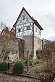
Former castle | Since 1413 the seat of the Limpurg taverns and their descendants of the Counts of Limpurg and Rechteren: main building, three-storey quarry stone masonry building with a saddle roof, stepped gable with decorative attachments and southern staircase tower, 1546–75 | D-6-79-187-46 |
 more pictures |
| Hauptstrasse 25 ( location ) |
Rear building | Two-wing and two-storey saddle roof building with half-timbered upper storey, northern part 15th century, remaining part 16th / 17th century. century | D-6-79-187-46 |
 more pictures |
| Hauptstrasse 25a ( location ) |
Former law firm | Two-storey, plastered saddle roof building with a basement and half-timbered upper storey, 18th century | D-6-79-187-46 |
 more pictures |
| Hauptstraße 25 ( ) |
Fountain | With the Limpurgian right coat of arms, inscribed "1791" | D-6-79-187-46 | |
| Hauptstrasse 25 ( location ) |
enclosure | Quarry stone, probably 17./18. century | D-6-79-187-46 |
 more pictures |
| Hauptstrasse 28 ( location ) |
pharmacy | Two-storey corner building with half-timbered upper storey and hipped or saddle roof, inscribed "1766" on the door walls | D-6-79-187-49 |
 more pictures |
| Hauptstrasse 30 ( location ) |
Residential building | Two-storey half-hipped roof building with half-timbered upper storey, 18th / 19th centuries century | D-6-79-187-50 |
 more pictures |
| Hauptstrasse 36 ( location ) |
Former residential building | Single-storey half-timbered building with a gable roof and solid base, 18th / 19th centuries century | D-6-79-187-51 |
 more pictures |
| Hauptstrasse 38 ( location ) |
Residential buildings | Two-storey, plastered mansard hipped roof building with half-timbered upper storey, drilled window frames and dwarf house, 18th century | D-6-79-187-52 |
 more pictures |
| Hauptstrasse 40 ( location ) |
Residential buildings | Two-storey, boarded gable roof building, probably with a half-timbered upper storey, inscribed "1789" on the door walls, possibly with an older core | D-6-79-187-53 |
|
| Hauptstrasse 40 ( location ) |
Courtyard gate pillars | With coat of arms, inscribed (15?) "59" | D-6-79-187-53 |
|
| Hauptstrasse 42 ( location ) |
Residential buildings | Two-storey saddle roof building with half-timbered upper storey, 18th century | D-6-79-187-54 |
 more pictures |
| Katharinengasse ( location ) |
Catherine fountain | Oval fountain basin and fountain column with figure of Fortuna (copy), original sandstone sculpture from the 17th century in the cemetery, inscribed "1831" | D-6-79-187-74 |
 more pictures |
| Katharinengasse 2 ( location ) |
Residential buildings | Two-storey, plastered mansard gable roof building with half-timbered upper storey, 18th / 19th centuries century | D-6-79-187-57 |
 more pictures |
| Katharinengasse 4 ( location ) |
Residential buildings | Gabled house, gable plastered half-timbering, 18th / 19th centuries century | D-6-79-187-59 |
|
| Katharinengasse 5 ( location ) |
Winery, residential building | Two-storey quarry stone masonry building with a gable roof, 16th century | D-6-79-187-60 |
 more pictures |
| Katharinengasse 5 ( location ) |
Winery, barn | Saddle roof construction, quarry stone and half-timbering, re. 1499 | D-6-79-187-60 |
more pictures |
| Katharinengasse 5 ( location ) |
Winery, outbuilding | Two-storey saddle roof building with half-timbered upper storey, round-arched door rel. 1587 | D-6-79-187-60 |
more pictures |
| Katharinengasse 5 ( location ) |
Winery, courtyard gate | Arched gate inscribed "1588", gate with drilled drapery, 18th century | D-6-79-187-60 |
 more pictures |
| Katharinengasse 6 ( location ) |
Former residential building | Two-storey, plastered gable roof building with half-timbered upper storey and drilled window frames, probably 18th century | D-6-79-187-61 |
|
| Katharinengasse 8 ( location ) |
Two-storey half-timbered house | 17./18. century | D-6-79-187-1 |
|
| Katharinengasse 9 ( location ) |
Former residential building | Two-storey, plastered saddle roof building with half-timbered gable, outer walls partially renewed, 1524, with a southern, two-storey porch with saddle roof, custom stone masonry with house stone integration, 18th / 19th century. century | D-6-79-187-63 |
 more pictures |
| Katharinengasse 12 ( location ) |
Courtyard gate | Round arch, inscribed "1611" on the apex | D-6-79-187-65 |
 more pictures |
| Katharinengasse 13, 15 ( location ) |
Duplex house | Two-storey, partially plastered gable roof building with half-timbered upper storey and gable, 17th century | D-6-79-187-66 |
 more pictures |
| Katharinengasse 19 ( location ) |
Residential buildings | Two-story quarry stone masonry building with a mansard gable roof and house integration, 1845 | D-6-79-187-68 |
 more pictures |
| Kirchplatz 2 ( location ) |
Evangelical Lutheran Parish Church of St. Bartholomew | Hall building with retracted choir and choir tower with Welscher dome, the core of the tower from the late 13th century, upper floors of the tower 1596, nave renovated after collapse in 1739, 1740; with equipment | D-6-79-187-69 |
 more pictures |
| Kirchplatz 15 ( location ) |
Former residential building | Two-storey, plastered hipped roof building with drilled window frames, 17th / 18th centuries century | D-6-79-187-70 |
 more pictures |
| Kirchplatz 15 ( location ) |
Courtyard gate | Simultaneously | D-6-79-187-70 |
 more pictures |
| Maingasse ( location ) |
Market fountain | Octagonal well basin on a stepped base, well column with figure of the knight Hans Jörg, sandstone, sculpture around 1574, basin from the 18th century, inscribed "1713", "1771" and "1781" | D-6-79-187-56 |
 more pictures |
| Maingasse 2 ( location ) |
Gasthaus zum Anker | Three-part building group, consisting of two-storey mansard roof buildings with half-timbered upper storey, in the core 1598, 18th century | D-6-79-187-71 |
 more pictures |
| Maingasse 2 ( location ) |
Protective wall | Bow-shaped quarry stone wall, at the same time | D-6-79-187-71 |
|
| Maingasse 5 ( location ) |
Wine economy | Two-story saddle roof building with half-timbered upper floor | D-6-79-187-72 |
 more pictures |
| Maingasse 5 ( location ) |
boom | Inscribed "1828", 18th century | D-6-79-187-72 |
 more pictures |
| Maingasse 14 ( location ) |
Residential buildings | Former covered gate entrance, two-storey saddle roof building with half-timbered upper storey protruding on consoles, ground floor overformed, 18th century | D-6-79-187-47 |
 more pictures |
| Maingasse 17 ( location ) |
Former residential building | Two-storey, plastered gable roof building with half-timbered gable, 17th century core, changed in the 19th century | D-6-79-187-73 |
 more pictures |
| Maingasse 17 ( location ) |
Courtyard entrance | Round arch, inscribed "1605" | D-6-79-187-73 |
 more pictures |
| Mönchshof 3 ( location ) |
Former residential building | Two-storey, plastered gable roof building with timber framing projecting over consoles on the eaves side, 17th century core | D-6-79-187-75 |
|
| Mönchshof 7 ( location ) |
Residential buildings | Two-storey, plastered saddle roof building with half-timbered upper storey, labeled "1666" | D-6-79-187-76 |
 more pictures |
| Mönchshof 9 ( location ) |
Residential buildings | Two-storey, plastered saddle roof building in corner position, with half-timbered upper storey, inscribed "1764" | D-6-79-187-77 |
 more pictures |
| Mönchshof 10 ( location ) |
Residential buildings | Two-story, plastered gable roof building with half-timbered upper floor and adjoining rear building, 17th century | D-6-79-187-78 |
 more pictures |
| Mönchshof 16 ( location ) |
Courtyard gate | Round arch, inscribed "1631" | D-6-79-187-79 |
 more pictures |
| Near Ölspielstraße ( location ) |
graveyard | Regular walled complex in front of the city wall, with a historical part to the south around 1607 and a modern cemetery extension to the north, with preserved grave monuments from the late 16th to the 20th century | D-6-79-187-96 |
 more pictures |
| Near Ölspielstraße ( location ) |
Cemetery wall | Quarry stone masonry, around 1607 | D-6-79-187-96 |
|
| Near Ölspielstraße ( location ) |
Cemetery, arcade | Wooden, half-open construction with hipped roofing along the eastern wall of the cemetery, with a central, tower-like structure, underneath a stone, relief-decorated pulpit on a pillar, 1609 | D-6-79-187-96 |
more pictures |
| Near Ölspielstraße ( location ) |
Cemetery former morgue | Small quarry stone masonry building with a gable roof, probably at the same time | D-6-79-187-96 |
|
| Pastoriusgasse 4 ( location ) |
Former residential building | Two-storey, plastered saddle roof building with half-timbered upper storey, the core of the 18th century | D-6-79-187-80 |
|
| Pastoriusgasse 6 ( location ) |
Residential buildings | Two-storey, plastered gable roof building with drilled door frame, labeled "1764" | D-6-79-187-81 |
 more pictures |
| Plan 1 ( location ) |
Residential buildings | Two-storey saddle roof building with half-timbered upper storey, the core of the 16th century | D-6-79-187-82 |
 more pictures |
| Plan 2 ( location ) |
Former residential building | Two-storey, plastered hipped roof building with ornamental portal, 17th century, remodeled in the 19th century | D-6-79-187-83 |
 more pictures |
| Plan 4 ( location ) |
Residential buildings | Two-storey saddle roof building with half-timbered upper storey, labeled "1619", and with an eastern half-timbered extension, after 1825 | D-6-79-187-84 |
 more pictures |
| Plan 8 ( location ) |
Residential building, so-called old oak | Three-storey saddle roof building with half-timbered upper storeys and wooden external staircase, 16./17. century | D-6-79-187-85 |
 more pictures |
| Plan 10 ( location ) |
Residential buildings | One-storey, plastered mansard half-hipped roof with half-timbered gable, end of the 18th century | D-6-79-187-86 |
 more pictures |
| Rathausgasse 4 ( location ) |
Former residential building | Two-storey, plastered saddle roof building with half-timbered upper storey, the core of the 17th century | D-6-79-187-87 |
 more pictures |
| Rathausgasse 5 ( location ) |
Former residential building | Two-storey, plastered saddle roof building with half-timbered upper storey, 18th / 19th centuries century | D-6-79-187-88 |
 more pictures |
| Rathausgasse 6 ( location ) |
goal | Basket arch, inscribed "1804" | D-6-79-187-89 |
 more pictures |
| Rathausgasse 8 ( location ) |
Residential buildings | Two-storey, plastered hipped roof building with half-timbered upper storey as well as an easterly projecting extension with overbuilt gate, 17th / 18th centuries. Century, courtyard gate marked "1778" | D-6-79-187-90 |
 more pictures |
| Rathausgasse 9 ( location ) |
Residential buildings | Two-storey half-hipped roof building with half-timbered upper storey, 19th century | D-6-79-187-91 |
 more pictures |
See also
Remarks
- ↑ This list may not correspond to the current status of the official list of monuments. The latter can be viewed on the Internet as a PDF using the link given under web links and is also mapped in the Bavarian Monument Atlas . Even these representations, although they are updated daily by the Bavarian State Office for Monument Preservation , do not always and everywhere reflect the current status. Therefore, the presence or absence of an object in this list or in the Bavarian Monument Atlas does not guarantee that it is currently a registered monument or not. The Bavarian List of Monuments is also an information directory. The property of a monument - and thus the legal protection - is defined in Art. 1 of the Bavarian Monument Protection Act (BayDSchG) and does not depend on the mapping in the Monument Atlas and the entry in the Bavarian Monument List. Objects that are not listed in the Bavarian Monument List can also be monuments if they meet the criteria according to Art. 1 BayDSchG. Early involvement of the Bavarian State Office for Monument Preservation according to Art. 6 BayDSchG is therefore necessary in all projects.
literature
- Denis André Chevalley: Lower Franconia . Ed .: Michael Petzet , Bavarian State Office for the Preservation of Monuments (= Monuments in Bavaria . Volume VI ). Oldenbourg, Munich 1985, ISBN 3-486-52397-X .
Web links
- Bavarian Monument Atlas (cartographic representation of the Bavarian architectural and ground monuments by the Bavarian State Office for Monument Preservation (BLfD) )
- List of monuments for Sommerhausen (PDF) at the Bavarian State Office for Monument Preservation

Altertheim | Aub | Bergtheim | Bieberehren | Bütthard | Eibelstadt | Eisenheim | Eisingen | Erlabrunn | Estenfeld | Frickenhausen am Main | Gaukönigshofen | Gelchsheim | Gerbrunn | Geroldshausen | Gable City | Greußenheim | Güntersleben | Hausen near Würzburg | Helmstadt | Hettstadt | Höchberg | Wooden churches | Kirchheim | Box | Small cattle field | Kürnach | Leinach | Margetshöchheim | Neubrunn | Oberpleichfeld | Ochsenfurt | Prosselsheim | Randersacker | Reichenberg | Remlingen | Riedenheim | Rimpar | Rottendorf | Röttingen | Sommerhausen | Sonderhofen | Tauberrettersheim | Theilheim | Thüngersheim | Uettingen | Unterpleichfeld | Veitshoechheim | Waldbrunn | Waldbüttelbrunn | Winterhausen | Zell am Main