
Box
| coat of arms | Germany map | |
|---|---|---|

|
Coordinates: 49 ° 45 ' N , 9 ° 51' E |
|
| Basic data | ||
| State : | Bavaria | |
| Administrative region : | Lower Franconia | |
| County : | Wurzburg | |
| Management Community : | Box | |
| Height : | 373 m above sea level NHN | |
| Area : | 3.87 km 2 | |
| Residents: | 2648 (Dec. 31, 2019) | |
| Population density : | 685 inhabitants per km 2 | |
| Postal code : | 97270 | |
| Area code : | 09306 | |
| License plate : | WÜ , OCH | |
| Community key : | 09 6 79 154 | |
| LOCODE : | DE KZQ | |
| Community structure: | 2 districts | |
| Address of the municipal administration: |
Am Rathaus 1 97270 Kist |
|
| Website : | ||
| Mayor : | Volker Faulhaber ( SPD ) | |
| Location of the municipality of Kist in the Würzburg district | ||
 |
||

Kist is a municipality in the Lower Franconian district of Würzburg and the seat of the Kist administrative community .
geography
Geographical location
Kist is located in the Würzburg region between the Irtenberg Forest in the west and the Guttenberger Forest in the east. The place represents the highest situated municipality in the district of Würzburg, the highest point of which is the steeple of the parish church of St. Bartholomew .
Community structure
The community consists of two districts , the parish village of Kist as the main town and the wasteland of Irtenberg . The municipality is located in the districts of Kist and Irtenberger Wald.
Neighboring communities
| Waldbrunn | Eisingen | Hoechberg |
| Altertheim |
.svg)
|
Reichenberg |
| Gerchsheim | Small cattle field |
history
The first written mention of the place took place at the time of Charlemagne in the first description of the Würzburg market on October 14, 779 under the name Chistesbrunno . The spelling of the place name changed again and again in the following centuries, but remained essentially the same: Kistun (approx. 1150), Kisten (1260), Kitsten (1271), Kist (1324) or ... in villa ("in of the village ") Kisten (1324), villa Kyste (1337), Kyst (1356) or Kist (1356), Kist (1449), Kyste (1483), Kist (1594) and Kist or Kyste (both 1778). In the late Middle Ages and early modern times , the Franconian aristocratic family Zobel von Giebelstadt held local authority until 1502 and 1515, respectively, before Kist passed to the Würzburg monastery . For this, Kist was in a special situation, as the place did not initially belong spiritually to the diocese of Würzburg , but to the neighboring archdiocese of Mainz until 1656 (see section Religion ). Evidence of the recurring border disputes between the Bishopric of Würzburg and the Archbishopric of Mainz are not only this division of Kist into secular and ecclesiastical affiliation, but also some buildings and boundary marks: a border tower with a turnpike , which is said to have stood in the Kaltes Loch district on Diotweg , two pillars of sovereignty in the Irtenberger Wald (see section forester's house Irtenberg ) and last but not least the ruins of Guttenberg Castle in Guttenberg Forest, which was built against Kurmainz and destroyed in the Peasants' War in 1525 . In 1803 Kist then fell under the secularisation of the bishopric of Würzburg to the duchy of Bavaria , which is also for obtaining the Electorate 1623 Electorate of Bavaria (then as double electorate) or since the merger with the Palatinate in 1777 also Kurpfalz Bavaria was called . In the Peace of Pressburg (1805), Kist was awarded to Archduke Ferdinand of Tuscany to form the Grand Duchy of Würzburg , with which, after its early dissolution in 1814, it reverted to Bavaria, which had meanwhile been raised from the Duchy to a kingdom . Since the end of the monarchy and the associated dissolution of the Kingdom of Bavaria in 1918, Kist has belonged to the Free State of Bavaria, which was proclaimed in the same year. However, since the Kingdom of Bavaria had already lost its full state sovereignty when it joined the German Empire, which was founded in 1867 under the name of the North German Confederation and incorporated into it in 1871, Kist has also been part of the Federal Republic's international identity since 1949 Germany existing German Empire.
Population development
- 1582: "1 forester, 1 Häfner , 1 Beck and 8 teams"
- 1623: approx. 190 inhabitants
- 1748: approx. 440 inhabitants
- 1770: approx. 460 inhabitants
- 1786: 495 inhabitants
- 1814: 448 inhabitants
- 1830: 549 inhabitants
- 1831: 549 inhabitants
- 1840: 546 inhabitants
- 1871: 736 inhabitants
- 1875: 718 inhabitants
- 1880: 745 inhabitants
- 1885: 727 inhabitants
- 1890: 700 inhabitants
- 1895: 639 inhabitants
- 1897: 702 inhabitants
- 1900: 686 inhabitants
- 1919: 741 inhabitants
- 1925: 785 inhabitants
- 1939: 999 inhabitants
- 1946: 1294 inhabitants
- 1950: 1326 inhabitants
- 1953: 1322 inhabitants
- 1954: 1330 inhabitants
- 1955: 1331 inhabitants
- 1956: 1340 inhabitants
- 1957: 1389 inhabitants
- 1958: 1401 inhabitants
- 1959: 1436 inhabitants
- 1960: 1451 inhabitants
- 1961: 1456 inhabitants
- 1962: 1579 inhabitants
- 1963: 1656 inhabitants
- 1964: 1690 inhabitants
- 1965: 1769 inhabitants
- 1966: 1809 inhabitants
- 1967: 1900 inhabitants
- 1968: 1894 inhabitants
- 1970: 1890 inhabitants
- 1971: 1901 inhabitants
- 1972: 1939 inhabitants
- 1973: 1993 inhabitants
- 1974: 2064 inhabitants
- 1977: 2200 inhabitants
- 1978: 2213 inhabitants
- 1987: 2293 inhabitants
- 1991: 2422 inhabitants
- 1995: 2491 inhabitants
- 2000: 2474 inhabitants
- 2005: 2434 inhabitants
- 2006: 2470 inhabitants
- 2007: 2453 inhabitants
- 2008: 2427 inhabitants
- 2009: 2433 inhabitants
- 2010: 2423 inhabitants
- 2011: 2447 inhabitants
- 2012: 2458 inhabitants
- 2013: 2470 inhabitants
- 2014: 2495 inhabitants
- 2015: 2551 inhabitants
- 2016: 2528 inhabitants
- 2017: 2547 inhabitants
- 2018: 2611 inhabitants
religion
Catholic Church
Kist has always been predominantly Catholic . Originally, from an ecclesiastical perspective, Kist belonged to the original parish of Tauberbischofsheim , before Kist was raised to its own parish. This could have been done before 1423, as the occupation with a folk priest named Fridericus is documented for that year . In any case, this first parish existed since 1487 at the latest, as the parish Kist as the easternmost in that year Country Chapter was recognized Taubergau of the Archdiocese of Mainz, to which it belonged until 1656 (see below). At this point in time you were under “Irdenberg, Meysenbach and Rinderfeld minor”. Whether this first Kister parish continued to exist after the Thirty Years' War or whether it had perished in its wake was the subject of discussions for centuries. On the one hand, Kist was often referred to as "Kaplanei", "filiali" or "Pastorey" from Kleinrinderfeld, and attempts were made to "tear Kist away from Kleinrinderfeld and make it an independent parish again", what a thing previous downfall speaks. On the other hand, however, the Kister citizens refused in 1783 to contribute to the construction of a new rectory in Kleinrinderfeld, pointing out that they were actually not chain stores, after the parish seat had previously been in Kist. On the other hand, a letter from the royal government of Lower Franconia and Aschaffenburg dated May 3, 1870: “The alleged branch status of the church in Kist turns out to be unfounded. After the confirmation of the bisch. Ordinariates of July 15, 1854, the later union of Kist with Kleinrinderfeld was a unio per aequalitatem [= association for legal equality], through which the previously existing legal relationships did not suffer a change, as a result of which Kist still had its own parish seal and parish register exists and the pastor of Kleinrinderfeld has called himself 'Pastor of Kleinrinderfeld and Kist' until recently ”. Taking these view of a union on equal rights basis, which should be done in the 17th century, can therefore be said that there were at that time two independent parishes and the parish priest of Kleinrinderfeld in personal union of the parish was also pastor of Kist, Kist but nevertheless a chaplain was assigned.
In the following years, however, Kist received the status of an exposition of the parish Kleinrinderfeld in 1890 and retained this until 1952, so that Kist's branch status is indisputable, at least for this period. The chaplain for Kist, who was subordinate to the mother parish Kleinrinderfeld, accordingly used the designation Expositus . The final re-establishment of the parish of Kist took place at the instigation of Expositus Konrad Keller in 1952.
The classification of the parish Kist was similarly complicated from a diocesan point of view: although the place was secularly part of the Würzburg monastery until 1803 (see section history ), the parish Kist was ecclesiastically assigned to the Archdiocese of Mainz until 1656 , which was due to the former membership of the original parish Tauberbischofsheim . Only from that point in time was the secular ruler ( Hochstift Würzburg ) also the spiritual lord ( Diocese of Würzburg ) in personal union . However, until the secularization, the dean of Bischofsheim still had the right to present Kist.
Today the Kister parish of St. Bartholomäus with its Reichenberger branch Appearance of the Lord belongs to the parish community Kreuz Christi, founded in 2010, in the deanery of Würzburg left of the Main of the diocese of Würzburg. Your church is the parish church of St. Bartholomew in Kist.
The kister local Catholic clergy in chronological order:
- Pastor:
- around 1423: Fridericus (people priest in Kist)
- before 1512: Konrad Nyckel
- 1512-1515: Johann Kleyn
- after 1515: Balthasar Engel
- around 1549: Sigismund Hartmann (pastor of Schönfeld, steward)
- around 1625: Bernhard Hausler (self-designation as "Pastor Kleinrinderfeld et Kist")
- Small cattle fields chaplains for Kist:
- around 1780: Kaspar Scheuring
- 1785: Josef Friedrich
- 1787: Georg Müller (from Randersacker )
- 1788: Adam Michel
- 1795: Michael Heilmann (died 1797 in Kist)
- 1797: Balthasar Machert
- 1798: Christoph Riegel
- 1801: Jos. Anton Eisenmann
- 1802: N. Viermeisel
- 1803: Sebastian Burgstaller
- 1810: NN Wagner
- 1811: NN Feuerstein
- 1829: Josef Weck
- 1831: Josef Anton Wolf
- 1833: Johann Schmitt
- 1839: Joh. Nepomuk Wirth
- 1842: Martin Wengel
- 1846: Georg Gunz
- 1850: Michael Zorn
- 1851: Johann Alig and Christian Trunk
- 1852: Ignaz Oberle
- 1853: Johann Bauer
- 1854: Franz Zanoni and Josef Konrad
- 1856: Josef Maier
- 1859: Franz Schmitt
- 1860: Kaspar Dietz
- 1865: Josef Seibold
- 1874: Karl Sersi
- 1878–1888: N. Schaab, Anton Bartholome, Joh. Herbert, Adam Wollbach
- Small cattle fields chaplains for Kist (as expositi):
- 1892–1896: Johann Hochdörfer
- 1896–1898: Ernst Ankenbrand
- 1899–1905: Ulrich Glöggler
- 1905–1911: Alfons Maria Broili
- 1911-1917: Martin Popp
- 1918–1927: Johann Siedler
- 1927–1936: Karl Gehrlich
- 1936–1940: Lukas Pfister
- 1940–1946: Josef Knorz
- 1946–1952: Konrad Keller
- Pastor of Kist:
- 1952–1953: Heinz-Erich Keller
- 1953–1973: August Pfannes
- 1974-2010: Konrad Martin
- Pastor for Kist:
- since 2010: Jerzy-Andrzej Jelonek (pastor of Waldbrunn, head of the parish community) and Karl Rost (retired priest, retired cathedral capitular, honorary prelate of His Holiness )
- 2010–2016: Leo Beck OFMConv (former provincial minister and general assistant), parish vicar
- 2016–2018: Mario Muschik CMM (former Provincial , now Vice Provincial), Parish Vicar and Stuart Vukayi CMM, Deputy Parish Vicar
Evangelical Lutheran Church
Due to the strong Catholic character of the place, Kister citizens of the Evangelical Lutheran denomination were always a minority. For the first time in 1830, two residents of Protestant denomination are attested, in 1871 nine of the 736 residents were Protestants , in 1905 ten Protestant Christians lived in the community (one in Kist, three in Guttenberg , six in Irtenberg), and in 1970 their share was then to 9.9% of the population.
The Evangelical Lutheran Christians in Kist therefore initially belonged to the Reichenberg parish, before the Eisingen - Kist - Waldbrunn parish with its seat in Eisingen was created at the beginning of 1991. This is assigned to the parish office of Höchberg and belongs to the deanery district of Würzburg in the parish of Ansbach-Würzburg of the Evangelical Lutheran Church in Bavaria . Your church is the Philippuskirche in Eisingen, built between 1997 and 1998 .
The pastors of the parish in chronological order:
- Pastor:
- 1992–2010: Peter Fuchs
- since 2010: Kirsten Müller-Oldenburg
-
Vicars :
- 2001–2004: Kerstin Voges
- 2004–2006: Heidi Herbert
- 2013–2016: Knut Cramer
politics

Municipal council
In the local elections on March 15, 2020, 1,533 of the 2,180 residents eligible to vote in the municipality of Kist exercised their right to vote, bringing the voter turnout to 70.32%.
mayor
1. Mayor is Volker Faulhaber ( SPD ). In 2002 he succeeded Walter Öhrlein ( CSU ). In the local elections on March 15, 2020, he was re-elected with 70.39% of the vote.
The Kister local heads in chronological order:
-
Schultheißen :
- around 1532: Hans Ebert
- around 1566: Claus Gert
- around 1582: Jörg Bernhard
- around 1683: Philipp Kogler
- around 1720: Johann Schmitt
- around 1750: Johann Adam Schmitt
- around 1760: Paulus Keller
- around 1783 and 1811: Jakob Schmitt
- 1817–1824: Friedrich Weber (from 1818 as "local leader")
- Mayor:
- 1817–1824: Friedrich Weber
- 1824–1836: Barthel Feßler
- 1837–1839: Johann Spiegel
- 1839–1845: Johann Konrad Leo
- 1845–1852: Kaspar Weber
- 1852-1857: Peter Willmy
- 1858–1871: Nikolaus Joh. Stetter (from 1868 as "Mayor")
- (First) Mayor:
- 1858–1871: Nikolaus Joh. Stetter
- 1871-1882: Peter Willmy
- 1882-1896: Adam Anton Leo
- 1897–1911: Peter Huller
- 1912–1918: Klemens Scheder
- 1919–1920: Peter Huller
- 1920–1924: Klemens Scheder
- 1925-1945: Oskar Popp
- 1945–1948: Alfons Schneider
- 1948–1952: Valentin Scheder
- 1952–1953: Oskar Popp
- 1953–1972: Otto Seubert
- 1972–1990: Wilhelm Scheder
- 1990–2002: Walter Öhrlein
- since 2002: Volker Faulhaber
coat of arms
|
|
Blazon : “Split by silver and red; in front a green deciduous tree on a green lawn, behind a silver horse's head with a black bridle. " |
| Justification of the coat of arms: A village seal can be proven for the place Kist, which shows a tree with rich foliage standing on the lawn as a local mark, and which has been preserved on a document from 1767. Another characteristic is the coat of arms of the Franconian aristocratic family Zobel (bridled horse's head), who held local authority there until 1502 and 1515 before the transition from Kist to the Würzburg monastery. The red and white colors are reminiscent of the rule of the Würzburg region. |
Alliance Waldsassengau
Together with twelve other communities from the western part of the Würzburg district, Kist belongs to the Allianz Waldsassengau im Würzburger Westen e. V. at. The alliance is organized as an association and aims to strengthen inter-municipal cooperation between its member communities by creating common structures and pooling resources.
It should be made clear, however, that Kist and Irtenberg did not historically belong to the early medieval Waldsassengau of the same name , but as a border town to the (lower) Taubergau .
Architectural and ground monuments
Two maps from the 19th century show the structural situation in Kist at that time (local paper "Kist (1833)" ) and the location of the place in the vicinity (original position paper "Heidingsfeld and the surrounding area in 1849" ).
Catholic parish church of St. Bartholomew
,_von_S%C3%BCden.JPG)
|
,_von_Osten.JPG)
|
|
|
Catholic parish church of St. Bartholomew (with village square), 2013
|
||
The listed Kister parish church of St. Bartholomäus was built between 1871 and 1872 in the neo-Romanesque style. A detailed description and more detailed information on their building history, their equipment and the previous buildings can be found in the main article. In addition to the church as such, the area around it is also entered as a ground monument in the Bavarian list of monuments (designation: Archaeological findings in the area of the medieval and early modern predecessor buildings of the late modern Catholic parish church of St. Bartholomew in Kist , monument number: D-6-6225 -0315).
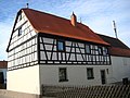
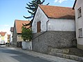
Gasthaus Grüner Baum with tithe barn
The listed inn with the distinctive Franconian half-timbering, which is partly still under plaster, is likely to be the oldest building in Kist. A coat of arms relief attached to the outer wall bears the year 1705, but it is assumed that this was only one year of the renovation. That relief shows a depiction of the Virgin Mary flanked by two angel heads and an inscription with the wording Under your protection and umbrella, we flee, O holy God-giving birth . Below is the coat of arms of the then Würzburg prince-bishop Johann Philipp von Greiffenclau zu Vollraths , for whom the property is said to have once served as a hunting seat, as well as another inscription with the text In the year of Christ Anno 1705 . A rococo bracket is attached to the gabled house with half-timbered upper floor and crooked hip, in the center of which there is a green and gold miniature representation of a tree and a lantern. The complex also includes a well-preserved barn from the time the property was built, which formerly served as the town's tithe barn . Above the entrance to the cellar is the symbol for the butchers, an ox head made of red sandstone with two crossed axes above, only one of the inscriptions . . Flat share 2. can be deciphered. This probably points to the year 1720, in which the barn was apparently partially basement. On the square in front of the inn is the replacement building of the so-called Anna's house , which once housed a privately owned linden wood figure of the Holy Mother Anna or a Madonna with baby Jesus in the Baroque style. A sign indicates a linden tree that is said to have stood next door for around 400 years, but which had to be felled for safety reasons due to a lightning strike. The Anna house is also a listed building.
,_2014..jpg)
,_bezeichnet_1706.jpg)
,_von_Nordwesten,_bezeichnet_1706.jpg)
,_2014.jpg)
_1.jpg)
_2.jpg)
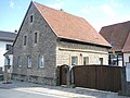
Former Gasthaus Zur Linde
,_wohl_17._oder_18._Jahrhundert.jpg)
In the courtyard north below the intersection of Untere Dorfstrasse and Vordere Bergstrasse is the former Zur Linde inn . It probably dates from the 18th century and has a half-timbered upper floor beneath its artistically plastered facade. In the 1930s, a hall was added, which served as the town's dance hall until the inn was closed. Today the old dance hall is occasionally used for private exhibitions and cultural events.
Area of the former Weth
In the area of today's village fountain in Untere Dorfstraße there was a Weth (i.e. a public drinking trough) in earlier times. As a sketch from 1770 shows, the area around the so-called common square also included a baroque wayside shrine at the village fountain (see section shrines ) and the “obedience house” opposite. Whether this is the building in the area with the inscription "Lagerhaus" or the Gaden building made of quarry stone with a half-timbered upper storey to the west requires further clarification. The latter is supported by the unusual steeply sloping masonry, which also forms the foundation of the adjoining large barn and has a clear defensive character. The area around the village fountain with the wayside shrine was extensively renovated in 2013 as part of the road renewal. The area at the intersection of Eisinger Straße and Waldbrunner Straße and Untere Dorfstraße is entered as a soil monument in the Bavarian monument list (designation: body graves from prehistoric times , monument number: D-6-6225-0132).
The area is not to be confused with the Alte Weth barbecue area , the name of which goes back to the Alte Weth corridor . This corridor also refers to another public drinking area, which was located in the Kaltes Loch corridor , a so-called valley since the Middle Ages, but the shape of which has been greatly changed by the construction of the A3 motorway and the drainage of the Margarethenseelein (now a forest sports ground) has been.

The area around the village fountain in a sketch from 1770

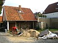
Farm building with half-timbered and (weir -?) Masonry (probably 18th century)
.jpg)
,_vor_1770.jpg)
Forester's house Irtenberg
In a small community exclave in the predominantly community-free Irtenberg Forest, about three and a half kilometers southwest of the center of the village, the former forester's house or forest estate Irtenberg is located in a clearing . The listed two-storey hipped roof building with the drilled frames dates from the first half of the 18th century and served, among other things, as a royal Bavarian forester's lodge, as a restored blue and white painted signpost on the main road in Kist reveals. The Bavarian customs office was also housed there until 1836. A forester's house must have been there much earlier, since in 1592 a building cost statement by the then Würzburg prince-bishop Julius Echter von Mespelbrunn mentions a new building: 205 fl. 4 pounds 1 alden kr. Cost the forester's house in Irtenberg to bawen all over again .
In the forest near the property there are two pillars of sovereignty from 1584, which Julius Echter had erected after numerous border disputes with his neighbor Kurmainz at the intersection of the former escort and the old wine route. The two pillars of sovereignty, which are over four meters high, also known as “escort pillars” or “folding rules”, are made of red sandstone and show the coats of arms of the Würzburg monastery and the prince-electoral monastery of Mainz, as well as an inscription above each. The inscription above the Würzburg column reads Wirtzburgische Gelaid Zennth Wildban Hohe und Nider Obrigkeit ec ; the high and low upper level above the Mainzisch Maintzisch Glaid Cent inch wildtban . In the 1930s, the escort pillars were relocated approx. 150 m in a southerly direction along today's Bavarian - Baden-Württemberg border for their own protection as part of the expansion of today's St 578. At the instigation of the Friends of Waldbrunn Monuments , a comprehensive renovation was carried out by the Free State of Bavaria in 2006.
Old school
.JPG)
|
.JPG)
|
|
|
Old school house from 1872, today the community library
|
||
Opposite the cemetery is the old school building from 1872. Today it offers space for the community library on the ground floor, otherwise it is used as a residential building.
Parish home
The parish home was built in 1912 as a nursery for small children with outpatient nursing. The construction goes back essentially to the last will of the native Kisterin Elisabeth Seubert, who provided 12,000 marks from her estate for the construction. On the outer wall of the front at the level of the first attic is a statue showing the adult Jesus with a little boy on his left arm and a girl on his right hand. The original roof landscape was lost through renovation. Today the building is used by the Catholic parish of St. Bartholomew as an event hall.


.jpg)
Wayside shrines
.JPG)
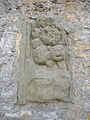
In the outer area of the Catholic parish church there is a sandstone shrine with a baroque headboard. It probably shows a representation of the circumcision of Christ on the front and figures of St. Sebastian , St. Kilian and St. Barbara on the reverse , flanked on both sides by two angel heads. The inscriptions below the representations are no longer legible today. The headboard, created around 1700, was originally located near the Erbachshof near Eisingen . It later served as the tomb of Theo Ernst Adalbert von Guérard (1917–1976) in the Kister cemetery, who purchased the Erbachshof estate from his father Baron Theodor von Guérard Senior (not to be confused with Theodor von Guérard ) in 1931/1932 and converted it into a hotel operated until 1972. After the grave was dissolved in 1996, the headboard was initially stored in Erbachshof in the Anton Fuchs restoration company. It was only on the initiative of Kister pastor Konrad Martin that the Kist community made contact with the owner and the owners, the heirs of the late Baron von Guérard, seven years later, from whom the Kist community was finally able to purchase the headboard. She then had it professionally restored between 2004 and 2005 and set up with a newly created torso as a wayside shrine next to the parish church. Since it is assumed that the headboard has always been part of a former holy blood wayside shrine, it is of great importance for the Kister Walldürn pilgrims, whom it has now been the starting point since its inauguration on May 6, 2005 for their pilgrimage to the Holy Blood in Walldürn .
.jpg)
At the cemetery there is a contemporary wayside shrine made of shell limestone from 1978/1979. It stands in place of a wayside shrine from the 18th century, which showed a relief of Christ on the Mount of Olives, and of which only an upside-down anchor piece with the letters KH was recognizable on the base , probably pointing to the donor, probably the Kister mason Kaspar Hümmer (1726–1786), suggested. Under the scooped relief of today's wayside shrine is the inscription Father, if you want, let this chalice pass me by . A Christ monogram is depicted on the back of the headboard; the base here bears the inscription Kist 779–1979 Lord protect our community further In Memoriam KH [anchor picture] 1750 .
In the cemetery today there is a cemetery cross created in 1977, which serves as a replacement for the old cross, which was made of red sandstone and carried a light Christ body (probably 18th / 19th century).
In Altertheimer Weg there is another contemporary wayside shrine made of shell limestone, the land consolidation shrine, with the inscription Holy our gifts through your spirit .
Opposite was the figure of a cruiser, which had been erected by Peter and Michael Dürr in 1891, but was later broken.
_2.jpg)
Another wayside shrine from 1763 is located outside the village on Uengershäuser Weg , of which the base is still preserved. This bears the inscription: To Eren Jessu and his mother in pain [i] this bilt stick was raised here in the year 1763 . The headboard is a later creation: It shows a smaller depiction of a Pietà , including the inscription Anno 1982 . Whether the square pillar is the baroque original or a re-creation requires further clarification. The wayside shrine is a listed building.

From 1764, a similar shrine, once (probably south) at the corner of the junction of the stems Lehmgrubenstrasse of the cattle Straße stand, and is obtained from the also only the base. Its inscription reads: To eren Jessu and Maria hatt Willhe [l] m king and Kadrina king in disen biltstoc [k] hir up. Anno 1764. The founders were the couple (Johann) Wilhelm König (1731–1787) and (Maria) Katharina König, geb. Fessler (1730-1798). The base used to carry a square column with a rounded top that housed a figure of Mary in its niche. The base is now in private hands.
.jpg)
Walled into the outer wall of the 18th century Gasthaus Zum Hirschen on the main street, there is a small, listed sandstone depiction of a Pietà with an inscription and underneath a butcher's coat of arms with the year 1720. This depicts an ox's head with two axes crossed over it , which is flanked on both sides by a star and the letters W (left) and G (right), which alone or together with the stars probably indicate the authorship of the founder. The inscription between the Pietà and the ox head, which in shape and size, but also with a view of the same initials W and G , is similar to that at the basement entrance of the Grüner Baum inn , reads: Under your protection and umbrella I flee, O holy Gebr in our [ Needs] .
For Marie Relief 1705 at the Inn Green Tree see above section Gasthaus Grüner Baum .
A listed sandstone relief from 1818 depicting the Trinity of God the Father, God the Son and God the Holy Spirit as well as a Pietà and , according to the inscription VM 1818 KM , probably by Valentin Mayer (1782–1831) and Kunigunde Mayer (1778– 1843), was previously on the street-side outer wall of a farm building on the property at Untere Dorfstraße 14a . However, for security reasons it was removed and is now kept private. The striking farm building, which was previously used as a forge, was demolished as part of the renovation of Untere Dorfstraße . A new building was erected in its place, on the outer wall of which there is now a copy of the relief, depicting the original situation.
Almost no longer recognizable is a relief that is attached two houses to the east to a farm building on the property at Untere Dorfstrasse 16 . This could be the rest of a Thanksgiving shrine.
In a private garden of the property Untere Dorfstrasse 1 or Untere Dorfstrasse 3 below the village fountain was a classicist female figure, donated by the mayor at that time Jakob Schmitt in 1811, with her head resting on a ball with her left arm and a book with the inscription Kurz in her right hand is time, long is eternity .
At the village fountain , which was newly created in 1977, there is a contemporary wayside shrine, which serves as a replacement for a weathered baroque shrine that was previously used there, the top of which was shaped like a crown. Its exact appearance could at best be reconstructed using existing old drawings. The current wayside shrine was created in 1975 and represents the blood miracle of Walldürn .

Another shrine is located in the garden of the Catholic daycare St. Bartholomew in the Kiln Road . The headboard shows a representation of the Holy Family: St. Joseph on the left and Mary, the Mother of God, on the right, the Child Jesus in the middle. Below is the ancient text of Jesus Maria Joseph help us . The wayside shrine originally stood on the outer wall of a now demolished barn on the northeast corner of Obere Dorfstraße and Brennofenstraße and, due to its similarity to the two other wayside shrines or wayside bases from the 18th century, possibly also from this period and probably from the hand of the same sculptor.
In the northeast corner of the intersection of Wiesenstrasse and Steinstrasse there is a tall contemporary Marian column made of shell limestone.
A contemporary Marian relief has been attached to the outer wall of the rectory on Brennofenstrasse since September 2016 .

Ensemble war memorial
In 1937 the Würzburg sculptor Friedrich erected a war memorial in honor of the soldiers who fell in World War I next to the old building of the Oskar Popp School . In the middle it shows a larger than life soldier who supports his fallen comrade. To the left and right there are memorial plaques with the names of the Kister soldiers killed in a semicircle. After the Second World War, the circle was closed with further memorial plaques and a lattice gate.
The ensemble also includes the old building of the Oskar Popp School, which was built in 1935 and expanded in 1937 and which was initially called the Ludwig Siebert School, as well as the current research house of the primary school, also built in 1937 as the HJ home , a lighthouse project for the Profiling as a MINT- friendly school.
.jpg)
.jpg)
.jpg)
Water tower
As a second landmark, the 30.40 m high water tower has been enthroning the roofs of the community since 1960 .
Barrows
In the vicinity of the forest sports field northeast of Kist in the Kaltes Loch district there is a burial mound field with four burial mounds from the Bronze and Hallstatt periods , which were the subject of archaeological excavations in 1941 and 1960 with a view to the planned motorway construction. The area there is registered as a ground monument in the Bavarian monument list (designation: burial mound of the Hallstatt period , monument number: D-6-6225-0185) and extends to an area that extends the area north and northeast of the forest sports field to the motorway, which from the motorway itself and the area to the north of it. Three of the burial mounds disappeared under the motorway embankment in the course of the construction, one is still visible today (as of 1979, see footnote), albeit hidden in the undergrowth, as there is no way to get there. The burial mounds contained or contain several, usually three graves. A total of 30 burial mounds were found on Schulzenwiese and in Kalten Loch , three in Stöckach and one in Einsprung-West . While the finds made in 1941 and then kept in Würzburg, consisting of bowls, vessels, pottery shards, etc., were destroyed in the bomb attack on Würzburg in 1945, the finds made during the excavations carried out in 1960 can now be viewed in the Museum für Franken in Würzburg. More information from Friedrich Ebert: Chistesbrunno - Kist. 779-1979. 1979, p. 9 ff.
As excavations show, other finds, including those from the Middle Ages , could be made in and around Kist . But since no excavations are planned, one has to rely on chance finds during construction work or field and arable work (see the description in the article Depot find ), as they were made in Röttingen in the 20th century. This applies in particular to the entire old town area, which is why increased sensitivity in this regard is desirable.
Linear ceramics settlement
On the hill between Kist and the junction to Eisingen, traces of a linear ceramics settlement were found in the area west of the main road opposite the entrance to the Guttenberg Forest . This area is registered as a ground monument in the Bavarian list of monuments. On this hill there was once the so-called reclining chair , a bench made of three blocks of stone, which after a long period of temporary storage at the road construction office of the district in Waldbüttelbrunn, now together with a historical signpost to the Irtenberg forest house (name: Irtenberg Kgl.baÿr.Forsthaus → 4 km , Late 19th / early 20th century) has found its place at the southeast corner of the intersection of Hauptstrasse and Guttenberger Strasse / Rinderfelder Strasse .
Others
,_Vorderseite.jpg)
|
,_R%C3%BCckseite.jpg)
|
|
|
Border stone with real coat of arms (left picture), originally 16./17. century
|
||
In the forest near the forest sports field in the Kaltes Loch corridor, there is a boundary stone originally from the real time, which was probably reused in the 19th century in the same or a similar place. On its obverse, the coat of arms of the then Würzburg prince-bishop Julius Echter von Mespelbrunn can be seen, during whose reign the border town of Kist was part of the disputed area between the bishopric of Würzburg and the archbishopric of Mainz (see section History ).
In 1979, a memorial stone was erected outside the cemetery to mark the 1200th anniversary of the community. The stone originally served as a cover plate for a six to seven meter deep well in Untere Dorfstrasse , which is located at the intersection with Winterleiten Street in front of the building with the stone facade there. Until the renovation of Untere Dorfstraße in 2013, only the brick shaft remained, which, however, was covered with a manhole cover. In the course of the street renovation, the fountain was revived and walled up with the old stones of another fountain, which was discovered under the floor when the farm building with the relief of the Trinity (see section shrines ) was demolished. The spring water from the well that has been rebuilt in this way has so far been directed to the (third) well located on the opposite side of the street below the half-timbered house. The same situation is also found further west not far from today's village fountain (the fourth fountain in this area) in the upper parking area of the former Zur Linde inn .
Other buildings that shape the townscape

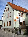
At the town hall 9 , stucco facade, re. 1913

Obere Dorfstraße 7 , former Gasthaus Zum Stern (first mention of a local tap in the 16th century)
Upper village street without number , so-called old smithy , 19th century (after 1833)

Obere Dorfstrasse 17 , half-timbered barn, probably 18./19. century

Obere Dorfstrasse 18 , former Dürr bakery , in the core 18./19. Century, renovation in the 1st half of the 20th century, renovated in 2019


Obere Dorfstraße 18 , half-timbered barn, early 20th century, re. 1904 (?)

Hintere Bergstrasse 2 , building with mansard roof, 18th / 19th centuries century

Hintere Bergstrasse 2 , farm building, formerly residential building (house number Kist 18 ), 18./19. century

Stadtweg 3 , half-timbered house on the village square, probably 17./18. Century, suspected former use as a school building


Vordere Bergstrasse 16 , half-timbered building (plastered), 19th century (after 1833)

Untere Dorfstraße 10 , farmhouse with half-timbered upper floor (plastered), probably 18th / 19th century. century

Untere Dorfstraße 13 , farmhouse with half-timbered upper floor, probably 18th / 19th century century


Untere Dorfstrasse 16 , farmhouse with quarry stone facade, probably 18th / 19th century century
Untere Dorfstrasse 16 , farm building, probably 18./19. century

Untere Dorfstrasse 20 , probably 18./19. century


Untere Dorfstrasse 26 , in the core probably 17./18. century

Untere Dorfstraße 28 , barn with double half-timbered upper floor, probably 18th century, renovated in 2019


Untere Dorfstrasse 30 , in the core probably 17./18. century

Untere Dorfstrasse 33 , farmhouse, probably 17th / 18th centuries century

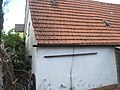
Untere Dorfstraße 34 , building with house Madonna, 19th century (after 1833)

Grombühlstraße 15 , half-timbered building, 19th century (after 1833)

Grombühlstraße 17 , quarry stone barn, 19th century (after 1833)

Grombühlstraße 20 , half-timbered building, 19th century (after 1833), demolished in 2019

Hauptstrasse 3 , re. 1935

Bauweg 1 , building with brick facade, 19th century (after 1833)

.JPG)
.JPG)


,_sp%C3%A4ter_Wirtschaftsgeb%C3%A4ude,_wohl_18._oder_19._Jahrhundert_2.jpg)


.JPG)


.jpg)


Economy and Infrastructure
economy
According to official statistics, there were 92 employees at the place of work in the manufacturing sector and 157 in the trade and transport sector. In other economic sectors, 117 people were employed at the place of work subject to social security contributions. There were a total of 913 employees at the place of residence subject to social security contributions. There were ten companies in the manufacturing sector and one in the construction sector. In addition, there were three farms in 1999 with an agricultural area of 77 hectares.
traffic
Kist is in close proximity to the federal highway 3 (junction 69 - Würzburg / Kist) and a few kilometers away from the federal highway 81 (junction 2 - Gerchsheim). The state road St 578 or federal road 27 as part of the Romantic Road and the district road WÜ 29 also lead through Kist .
Education and Social
There are the following public educational institutions:
- Crawl space
- Catholic day care center St. Bartholomäus
- Primary school Oskar-Popp-Schule with lunchtime supervision
- youth Center
- Community library
- Branch of the Volkshochschule Würzburg
Leisure time
The following leisure facilities exist in the municipality of Kist:
sport Center
- Sports and event hall Otto-Seubert-Halle
- Indoor tennis court with outdoor courts
- Community sports ground with tartan track and grandstand
- Hard court
- Beach volleyball court
- Bocce court
- Skater facility
- playground
Other sports facilities
- Forest sports field
- Table tennis tables (in the school yard of the Oskar Popp School )
- Private shooting range (in the clubhouse of the St. Sebastian Kist shooting club, 1966)
playgrounds
- Winterleiten adventure playground
- sport Center
- Spitzwiese / Herrleinsäcker
- Turmstrasse (at the water tower)
Others
- Sauna garden
- Cross-country ski trail in winter along the Guttenberger Forest to Limbachshof and Kleinrinderfeld
- Connection to the local cycle path network
- Forest trails
Personalities
Honorary citizen
- probably 1922: Viktor Uehlein, senior teacher (1911), senior teacher (1921), awarded after 25 years of service in Kist as a teacher (1897–1922)
- Otto Seubert, 1st Mayor (1953–1972)
- 2006: Wilhelm Scheder (1926–2017), 1st mayor, awarded in recognition of his services as a local councilor (1952–1990), 2nd mayor (1956–1972), 1st mayor (1972–1990) and member of the district council (1960 –1966 and 1979–1984), holder of the Federal Cross of Merit on Ribbon (1984), the municipal medal of merit in bronze (1990) and the district badge in silver (1990)
People related to the community
- Sabine Demel (born September 21, 1962 in Coburg ), theologian and university professor, lived in Kist for several years
literature
- Traudl Baumeister / Steffen Standke: Chronicle of Kist. History of a Changing Village 779–2012. bonitasprint GmbH, Würzburg 2012.
- Friedrich Ebert: Chistesbrunno - box. 779-1979. Vier-Türme-Verlag, Münsterschwarzach 1979.
- Friedrich Ebert: Church of St. Bartholomew and Parish Kist. Krug-Druck, Würzburg 1982.
- Friedrich Ebert: Kist - through the ages. Benedict Press, Münsterschwarzach 1986.
- Fritz Fink: Hike through the past of the Schwabach valley - the landscape between Erlangen and Graefenberg. Self-published, Eschenau 1999, ISBN 3-00-004988-6 .
- Konrad Martin: Church leader parish church St. Bartholomäus Kist. Kist 2006.
- Wolf-Armin von Reitzenstein : Lexicon of Franconian place names. Origin and meaning. Upper Franconia, Middle Franconia, Lower Franconia. CH Beck, Munich 2009, ISBN 978-3-406-59131-0 .
- Wolfgang Wiessner: City and district of Fürth (= historical place name book of Bavaria . Volume 1). Commission for Bavarian State History, Munich 1963, DNB 455524629.
- Heinz Willner: The two Würzburg mark descriptions. Self-published, Valencia (Spain) 2005, ISBN 3-00-016016-7 .
Web links
- Municipality of Kist Official website of the municipality of Kist
- Entry on the coat of arms of Kist in the database of the House of Bavarian History
- Kist: Official statistics of the LfStat (PDF: 1.05 MB)
Individual evidence
- ↑ "Data 2" sheet, Statistical Report A1200C 202041 Population of the municipalities, districts and administrative districts 1st quarter 2020 (population based on the 2011 census) ( help ).
- ^ Community Kist in the local database of the Bavarian State Library Online . Bayerische Staatsbibliothek, accessed on September 8, 2017.
- ↑ Ebert: Chistesbrunno - Kist. 779-1979. 1979, pp. 21-23.
- ↑ a b c d e f g Wolf-Armin von Reitzenstein : Lexicon of Franconian place names. Origin and meaning . Upper Franconia, Middle Franconia, Lower Franconia. CH Beck, Munich 2009, ISBN 978-3-406-59131-0 , p. 118 ( limited preview in Google Book search).
- ↑ a b c d e Ebert: Chistesbrunno - Kist. 779-1979. 1979, p. 23.
- ↑ Baumeister / Standke: Chronicle of Kist. History of a Changing Village 779–2012. 2012, p. 17.
- ↑ Ebert: Chistesbrunno - Kist. 779-1979. 1979, p. 109.
- ↑ Historia et Commentationes Academiae Electoralis Scientiarum et Elegantiorum Litterarum Theodoro-Palatinae, Volume IV. Historicum, Mannhemii Typis Academicis, MDCCLXXVIII (1778), p. 152 ( limited preview in the Google book search).
- ↑ Historia et Commentationes Academiae Electoralis Scientiarum et Elegantiorum Litterarum Theodoro-Palatinae, Volume IV. Historicum, Mannhemii Typis Academicis, MDCCLXXVIII (1778), p. 155 ( limited preview in the Google book search).
- ↑ Ebert: Chistesbrunno - Kist. 779-1979. 1979, pp. 70 and 93.
- ↑ See http://www.gemeinde-kist.de/index.php?id=46
- ↑ Guttenberg Castle. Retrieved March 18, 2020 .
- ^ → Bismarck's Imperial Constitution
- ↑ → Germany's legal position after 1945
- ↑ a b c d e f g h i j k l m n o p q r s t u v w x y z aa ab ac ad ae af ag ah ai Ebert: Chistesbrunno - Kist. 779-1979. 1979, p. 180 f.
- ↑ a b c d Bavarian State Statistical Office (Hrsg.): Historical municipality register: The population of the municipalities of Bavaria from 1840 to 1952 (= contributions to Statistics Bavaria . Issue 192). Munich 1954, DNB 451478568 , p. 215 , urn : nbn: de: bvb: 12-bsb00066439-3 ( digital copy ).
- ↑ a b kgl. Statistisches Bureau (Ed.): Results of the census in the Kingdom of Bavaria from December 1, 1871 according to individual communities . XXVIII. Issue of the contributions to the statistics of the Kingdom of Bavaria. Munich 1873, p. 189 ( online at the MDZ ).
- ↑ K. Bayer. Statistical Bureau (Ed.): Localities directory of the Kingdom of Bavaria. According to government districts, administrative districts, ... then with an alphabetical register of locations, including the property and the responsible administrative district for each location. LIV. Issue of the contributions to the statistics of the Kingdom of Bavaria. Munich 1888, Section III, Sp. 1309 ( digitized version ).
- ↑ K. Bayer. Statistical Bureau (Ed.): Directory of localities of the Kingdom of Bavaria, with alphabetical register of places . LXV. Issue of the contributions to the statistics of the Kingdom of Bavaria. Munich 1904, Section II, Sp. 1393 ( digitized version ).
- ↑ Bavarian State Statistical Office (ed.): Localities directory for the Free State of Bavaria according to the census of June 16, 1925 and the territorial status of January 1, 1928 . Issue 109 of the articles on Bavaria's statistics. Munich 1928, Section II, Sp. 1428 ( digitized version ).
- ↑ Bavarian State Statistical Office (ed.): Official place directory for Bavaria - edited on the basis of the census of September 13, 1950 . Issue 169 of the articles on Bavaria's statistics. Munich 1952, DNB 453660975 , Section II, Sp. 1244 ( digitized version ).
- ↑ Bavarian State Statistical Office (ed.): Official city directory for Bavaria, territorial status on October 1, 1964 with statistical information from the 1961 census . Issue 260 of the articles on Bavaria's statistics. Munich 1964, DNB 453660959 , Section II, Sp. 906 ( digitized version ).
- ^ Bavarian State Statistical Office (ed.): Official place directory for Bavaria . Issue 335 of the articles on Bavaria's statistics. Munich 1973, DNB 740801384 , p. 195 ( digitized version ).
- ↑ Bavarian State Office for Statistics and Data Processing (Ed.): Official local directory for Bavaria, territorial status: May 25, 1987 . Issue 450 of the articles on Bavaria's statistics. Munich November 1991, DNB 94240937X , p. 382 ( digitized version ).
- ↑ a b c d e f g h i j k l m https://www.statistikdaten.bayern.de/genesis/online?operation=previous&levelindex=2&levelid=1327876384425&step=2
- ↑ See fn. 1.
- ^ Martin: Church leader parish church St. Bartholomäus Kist. 2006, p. 13.
- ↑ Ebert: Chistesbrunno - Kist. 779-1979. 1979, p. 125.
- ↑ a b c Ebert: Brief history of the parish Kist , in: Ebert: Church of St. Bartholomew and parish Kist. 1982, p. 14.
- ^ So Martin: Church leader parish church St. Bartholomäus Kist. 2006, p. 0.
- ↑ Ebert: Chistesbrunno - Kist. 779-1979. 1979, p. 112 f.
- ↑ Ebert: Chistesbrunno - Kist. 779-1979. 1979, p. 117.
- ↑ Ebert: Chistesbrunno - Kist. 779-1979. 1979, p. 115.
- ↑ Translation by Ebert: Chistesbrunno - Kist. 779-1979. 1979, p. 113.
- ↑ Copy of the letter in the community archive Kist B6, in: Ebert: Chistesbrunno - Kist. 779-1979. 1979, p. 112 f .; see. also the self-designation of Bernhard Hausler around 1625 as "Pastor Kleinrinderfeld et Kist", Ebert: Chistesbrunno - Kist. 779-1979. 1979, p. 113.
- ↑ a b Ebert: Brief history of the parish Kist , in: Ebert: Church of St. Bartholomäus and parish Kist. 1982, p. 15.
- ↑ So Ebert: Chistesbrunno - Kist. 779-1979. 1979, p. 113.
- ↑ Ebert: Chistesbrunno - Kist. 779-1979. 1979, p. 125 f.
- ↑ Ebert: Chistesbrunno - Kist. 779-1979. 1979, p. 125; Martin: Church leader parish church St. Bartholomäus Kist. 2006, p. 0.
- ↑ See Martin: Church Leader Parish Church St. Bartholomäus Kist. 2006, p. 13.
- ↑ Ebert: Chistesbrunno - Kist. 779-1979. 1979, p. 125 f. or individual evidence.
- ↑ Ebert: Chistesbrunno - Kist. 779-1979. 1979, p. 113.
- ↑ Ebert: Order of pastors in Kist , in: Ebert: Church of St. Bartholomew and Parish Kist. 1982, p. 16.
- ↑ http://www.mainpost.de/regional/wuerzburg/Pfarrer-und-Pastoren;art736,9262525 . Retrieved August 1, 2016.
- ↑ http://www.mainpost.de/regional/wuerzburg/Beerdigungen-Pfarrer-und-Pastoren-Pfarrkirchen;art736,9268951 . Retrieved August 1, 2016.
- ↑ http://www.pg-kreuz-christi.de/pfarreisengemeinschaft/index.html . Retrieved October 4, 2016.
- ↑ https://www.mainpost.de/regional/wuerzburg/Domkapitular-em-Praelat-Karl-Rost-wird-90-Jahre-alt;art735,10306116 of September 2, 2019. Accessed on November 13, 2019.
- ↑ http://www.franziskaner-minoriten.de/leben/lebensbilder2/br--leo-beck . Retrieved August 19, 2018.
- ↑ http://www.mainpost.de/regional/wuerzburg/Interviews-Pfarrer-und-Pastoren-Religioese-Orden;art736,9301491 . Retrieved August 1, 2016.
- ↑ http://kist.pg-kreuz-christi.de/index.html/gemeinsamer-gottesdienst-und-verendung-von-p-mario-als-pfarrvikar/ee868ee4-88cd-4351-b651-6cad3f9190f4?mode=detail dated October 17, 2018. Retrieved December 4, 2018.
- ^ Bulletin Markt Reichenberg, No. 498, March 2017, p. 22 ( http://www.markt-reichenberg.de/2017 . Retrieved on August 4, 2017).
- ↑ Information sheet for the municipality of Kist, October 2018, p. 21.
- ↑ Ebert: Chistesbrunno - Kist. 779-1979. 1979, p. 122.
- ↑ Ebert: Chistesbrunno - Kist. 779-1979. 1979, p. 182.
- ↑ a b Archived copy ( memento of the original from October 21, 2010 in the Internet Archive ) Info: The archive link was inserted automatically and has not yet been checked. Please check the original and archive link according to the instructions and then remove this notice. . Retrieved September 30, 2016.
- ↑ Archived copy ( memento of the original dated February 5, 2016 in the Internet Archive ) Info: The archive link was inserted automatically and has not yet been checked. Please check the original and archive link according to the instructions and then remove this notice. . Retrieved September 30, 2016.
- ↑ Archived copy ( Memento of the original from October 21, 2010 in the Internet Archive ) Info: The archive link was inserted automatically and has not yet been checked. Please check the original and archive link according to the instructions and then remove this notice. , Archived copy ( memento of the original from September 30, 2016 in the Internet Archive ) Info: The archive link was inserted automatically and has not yet been checked. Please check the original and archive link according to the instructions and then remove this notice. and archived copy ( memento of the original from September 30, 2016 in the Internet Archive ) Info: The archive link was automatically inserted and not yet checked. Please check the original and archive link according to the instructions and then remove this notice. . Retrieved September 30, 2016.
- ↑ Archived copy ( memento of the original from September 30, 2016 in the Internet Archive ) Info: The archive link was inserted automatically and has not yet been checked. Please check the original and archive link according to the instructions and then remove this notice. and archived copy ( memento of the original from September 30, 2016 in the Internet Archive ) Info: The archive link was automatically inserted and not yet checked. Please check the original and archive link according to the instructions and then remove this notice. . Retrieved September 30, 2016.
- ↑ Archived copy ( memento of the original dated February 5, 2016 in the Internet Archive ) Info: The archive link was inserted automatically and has not yet been checked. Please check the original and archive link according to the instructions and then remove this notice. . Retrieved September 30, 2016.
- ↑ City council election 2020
- ↑ City council election 2020
- ↑ Mayoral election 2020
- ↑ U. a. Ebert: Chistesbrunno - box. 779-1979. 1979, p. 91 f. or individual evidence.
- ↑ a b c d e Ebert: Chistesbrunno - Kist. 779-1979. 1979, p. 134.
- ^ Entry on Kist's coat of arms in the database of the House of Bavarian History , accessed on September 8, 2017 .
- ↑ a b Ebert: Chistesbrunno - Kist. 779-1979. 1979, p. 93.
- ↑ http://www.allianz-waldsassengau.de/13-trägersgemeinden/kist.html . Retrieved February 21, 2017.
- ↑ See http://www.allianz-waldsassengau.de/allianz/%C3%BCber-die-allianz.html . Retrieved February 21, 2017.
- ↑ Historia et Commentationes Academiae Electoralis Scientiarum et Elegantiorum Litterarum Theodoro-Palatinae, Volume IV. Historicum, Mannhemii Typis Academicis, MDCCLXXVIII (1778), pp. 152 and 155 ( limited preview in the Google book search).
- ↑ http://www.bayerische-landesbibliothek-online.de/ortsblaetter/suche?oid=41452 . Retrieved August 15, 2015.
- ^ The original position sheets of the land surveying in Bavaria - preview: Heidingsfeld. Retrieved March 18, 2020 .
- ↑ a b c d e f g h i j k l m list of monuments by Kist, as of April 15, 2020, accessed on July 11, 2020
- ↑ Ebert: Chistesbrunno - Kist. 779-1979. 1979, p. 183.
- ↑ Coat of Arms Photos. Retrieved March 18, 2020 .
- ↑ Grüner Baum Kist - Restaurant - Hotel. In: website. Retrieved March 18, 2020 .
- ↑ So Ebert: Chistesbrunno - Kist. 779-1979. 1979, p. 138.
- ^ Willner: The two Würzburg mark descriptions. 2005, p. 58 (fn. 51).
- ↑ a b In Ebert: Chistesbrunno - Kist. 779-1979. 1979, p. 90.
- ↑ See http://www.gemeinde-kist.de/index.php?id=93 . Retrieved October 15, 2016.
- ^ Willner: The two Würzburg mark descriptions. 2005, p. 57 and p. 58 (fn. 51).
- ↑ Ebert: Chistesbrunno - Kist. 779-1979. 1979, p. 71.
- ↑ Ebert: Chistesbrunno - Kist. 779-1979. 1979, p. 26.
- ↑ a b c d Monuments and contemporary witnesses around and in Waldbrunn . Retrieved October 15, 2016.
- ↑ After Ebert: Chistesbrunno - Kist. 779-1979. 1979, p. 30.
- ↑ Ebert: Kist - through the ages. 1986, p. 84.
- ↑ a b Ebert: Chistesbrunno - Kist. 779-1979. 1979, p. 123.
- ↑ Archived copy ( Memento of the original from June 5, 2012 in the Internet Archive ) Info: The archive link was inserted automatically and has not yet been checked. Please check the original and archive link according to the instructions and then remove this notice. . Retrieved October 15, 2016.
- ↑ a b c d e Baumeister / Standke: Chronicle of Kist. History of a Changing Village 779–2012. 2012, p. 201.
- ↑ Ebert: Chistesbrunno - Kist. 779-1979. 1979, p. 132 f.
- ↑ Ebert: Chistesbrunno - Kist. 779-1979. 1979, p. 136.
- ↑ Ebert: Chistesbrunno - Kist. 779-1979. 1979, p. 135.
- ↑ a b c Ebert: Chistesbrunno - Kist. 779-1979. 1979, p. 137.
- ↑ Ebert: Chistesbrunno - Kist. 779-1979. 1979, p. 133.
- ↑ Ebert: Chistesbrunno - Kist. 779-1979. 1979, p. 64.
- ↑ Ebert: Chistesbrunno - Kist. 779-1979. 1979, p. 10 f.
- ↑ Ebert: Chistesbrunno - Kist. 779-1979. 1979, p. 12.
- ↑ Ebert: Chistesbrunno - Kist. 779-1979. 1979, p. 12 ff.
- ↑ Ebert: Chistesbrunno - Kist. 779-1979. 1979, p. 10.
- ↑ Ebert: Chistesbrunno - Kist. 779-1979. 1979, pp. 11 and 17.
- ↑ Ebert: Chistesbrunno - Kist. 779-1979. 1979, p. 160.
- ↑ Ebert: Kist - through the ages. 1986, p. 25.
- ↑ http://www.mainpost.de/regional/wuerzburg/Ehrenbuerger;art736,9618880 . Retrieved June 13, 2017.
Remarks
- ↑ On that October 14th, 779, a number of witnesses conducted a border crossing to measure the mark, which was recorded by the priest Bernger. For this it was necessary to indicate the fixed points passed. One of them was the Chistesbrunnon , from which the name of the settlement (Kist) was derived, which was in its vicinity.
- ↑ In Reitz Stone says, however: "The Erstbeleg [v. Reitsenstein refers to the document Kistun of 1150] is probably a plural form of the personal name * Kist . Based The epithet to Old High German gikist " can be made prosperous " , is the defining word of the field name Chistesbrunno , which was documented in 779 (copy of approx. 1000) . "
- ↑ Here in the meaning of family , cf. Jacob Grimm, Wilhelm Grimm: German Dictionary . 16 volumes in 32 sub-volumes. Leipzig 1854–1961. Vol. 12, Col. 1603, No. 5) " Team ".
- ↑ Here in the sense of common or general, ie public.
- ↑ New knowledge about the location of these and other border points in and around Kist such as lakes, old and z. Some of the high-altitude trails that still exist today (such as the so-called altuuig / altwic or diotwig , a prehistoric high-altitude trail that was already known as the "old road" in 779 and that, coming from the southwest of the Irtenberger forest , ran where the Gerchsheimer road is today and then into an arc to the east of today's Kister Altort along the streets of Altertheimer Straße , Am Rathaus , Goethestraße and further to the Kalten Loch in the direction of Höchberg) and the exact location of Chistebrunno , the fountain that gave the place its name, can be found at Heinz Willner: The two Würzburg Mark Descriptions , 2005, in particular pp. 57 ff., 177 ff., 216 ff. And 290 ff.
- ↑ This is the old field name for the forest clearing on which the so-called Margarethenseelein used to be. This was laid out dry and the forest sports field in the same place.
- ↑ This widespread field name, which is based on the Middle High German word stock with an appended collective suffix -ach , could refer to a previous slash and burn that left a field of tree stumps behind (see Wiessner: Stadt und Landkreis Fürth. 1963, p. 95) or could also simply designate the area of a deforested forest (cf. Fink: Wander through the past of the Schwabach valley , 1999, p. 148). It is possible that the field name only indicates a general forestry use of this part of the forest.
- ↑ This field name probably refers to the hunter's linguistic meaning of the term entry : In this sense it describes a device through which the game can jump into a fenced place, but not come out again; the gate is set up close to the foot of an outwardly lying hill so that it is possible to jump down into the surrounding area, but not up into the open ( https://www.enzyklo.de/Begriff/Einsprung , accessed on 22 November 2019).
- ↑ The aforementioned field names as well as other old field names in the vicinity such as Hirschtraenke , Salzlecke and Thiergarten as well as Quellenholz , Kirchholz , Stöckachs-Wiese , Im Stöckach suggest that these areas were previously used for the purpose of keeping wild animals or for forestry purposes - Admittedly not by the Kister population, but by and in favor of the Prince-Bishop (or later the Grand Duke and even later the King) as sovereign, since the Guttenberg Forest was then and now in state ownership. The Kirchholz corridor could also indicate the limited right of use of a parish or a monastery to this corridor. The field names Reüthschlag (or Unteres Reutholz ) and Imunder Reütholz could philologically indicate the location of a (medieval?) Settlement that resulted from (fire) clearing, cf. such as the place names ending in the suffix -reuth Bay reuth , Tirschen reuth , Konners reuth .
- ↑ See the presentation in the article Tauber .

Cities: Aub | Eibelstadt | Ochsenfurt | Röttingen
Markets: Bütthard | Eisenheim | Frickenhausen am Main | Gelchsheim | Gable City | Helmstadt | Höchberg | Neubrunn | Randersacker | Reichenberg | Remlingen | Rimpar | Sommerhausen | Winterhausen | Zell am Main
Municipalities: Altertheim | Bergtheim | Bieberehren | Eisingen | Erlabrunn | Estenfeld | Gaukönigshofen | Gerbrunn | Geroldshausen | Greußenheim | Güntersleben | Hausen near Würzburg | Hettstadt | Wooden churches | Kirchheim | Box | Small cattle field | Kürnach | Leinach | Margetshöchheim | Oberpleichfeld | Prosselsheim | Riedenheim | Rottendorf | Sonderhofen | Tauberrettersheim | Theilheim | Thüngersheim | Uettingen | Unterpleichfeld | Veitshoechheim | Waldbrunn | Waldbüttelbrunn
Unregulated areas: Gramschatzer Wald | Guttenberg Forest | Irtenberg Forest