
Erlabrunn
| coat of arms | Germany map | |
|---|---|---|

|
Coordinates: 49 ° 52 ' N , 9 ° 51' E |
|
| Basic data | ||
| State : | Bavaria | |
| Administrative region : | Lower Franconia | |
| County : | Wurzburg | |
| Management Community : | Margetshöchheim | |
| Height : | 180 m above sea level NHN | |
| Area : | 4.01 km 2 | |
| Residents: | 1792 (Dec. 31, 2019) | |
| Population density : | 447 inhabitants per km 2 | |
| Postal code : | 97250 | |
| Area code : | 09364 | |
| License plate : | WÜ , OCH | |
| Community key : | 09 6 79 128 | |
| LOCODE : | DE EUN | |
| Community structure: | 1 district | |
| Association administration address: | Mainstrasse 15 97276 Margetshöchheim |
|
| Website : | ||
| Mayor : | Thomas Benkert ( CSU / Ms. Voters / SPD / UB) | |
| Location of the community Erlabrunn in the district of Würzburg | ||
 |
||

Erlabrunn is a municipality and a parish village in the Lower Franconian district of Würzburg . Erlabrunn is known as a wine town and also has a sizeable population of fruit trees.
geography
The place is on the state road 2300, about ten kilometers north of Würzburg . The place is on the eastern slope of the Volkenberg and extends to the Main . Neighboring towns are Margetshöchheim and Veitshöchheim in the south, Leinach in the west and Zellingen and Thüngersheim in the north .
There is only the Erlabrunn district . The place belongs to the administrative community Margetshöchheim, whose administrative seat is in Margetshöchheim.
Erlabrunn can be reached through two entrances, the southern entrance (Margetshöchheim) and the northern entrance (Zellingen). The place can also be visited on foot via the lock on the east of the Main. The Franconian Marienweg runs through Erlabrunn .
Surname
etymology
The original name of the water body Harnobrunno consists of the Old High German words harin and brunno . They mean urine and well, in the sense of "unclean spring". In the 12th century there was a change in name that changed the name of the fountain to Erlenbrunnen . It was derived from the Middle High German adjective erlîn , which means alder . The explanation arises from this “source surrounded by alders”. The name of the spring was transferred to the place.
Earlier spellings
Earlier spellings of the place from various historical maps and documents:
|
|
history
Until the church is planted
In the 12th century, the Falkenberg Castle existed on the Volkenberg (the name at that time was Falkenberg) at the northern end of today's town. The residents of Falkenberg Castle were feudal men of the Ravensburg . As a punitive measure for the murder of the Würzburg bishop Konrad von Querfurt , the castle was razed . Today only a few stones from the ruin can be seen.
The first written mention of the place comes from the year 1209 and implies that the area of today's Erlabrunn belonged to the Counts of Rieneck. When the count took out a loan from the Bishop of Würzburg, he pledged the land to the Würzburg Monastery , which belonged to the Franconian Empire . As part of this was Erlabrunn - 1803 in Bavaria's favor secularized - then in the Peace of Pressburg (1805) of Archduke Ferdinand III. of Tuscany to form the Grand Duchy of Würzburg , with which it finally fell back to Bavaria in 1814. In the course of the administrative reforms in Bavaria - with the municipal edict of 1818 - today's municipality was created.
The Catholic parish church of St. Andrew was built around 1381. In 1597 the parish became independent after it had belonged to the parish of Hettstadt until then. Due to the danger of collapse, the church was demolished in 1655 and rebuilt in 1656. The church was consecrated on September 16, 1657. The interior of the church was partially renovated in 1999.
20th and 21st centuries
Village renewal has been promoted since 1991 under the motto "preserve the old and create the new". Above all, the thoroughfare through the old town and the adjacent alleys will be rebuilt. It started in the northern part of the thoroughfare, Zellinger Strasse. In the second construction phase, the area around the school will be renewed. The redesign of Würzburger Strasse (south of the school) has already been decided, but the construction work has been postponed indefinitely due to limited funds.
In order to meet the growing demand for building sites, the “Am Erlenbrunnen / Goldbühlein” building area, which is large for the conditions of the town, was developed in the north of the town in 2005. Legal and economic reasons were given to justify the size of the development. The development costs amounted to 2.3 million euros.
Population development
- 1875: 779 inhabitants
- 1900: 652 inhabitants
- 1925: 701 inhabitants
- 1970: 997 inhabitants
- 1987: 1320 inhabitants
- 1991: 1483 inhabitants
- 1995: 1582 inhabitants
- 2000: 1574 inhabitants
- 2005: 1601 inhabitants
- 2010: 1656 inhabitants
- 2015: 1742 inhabitants
politics
The community is a member of the Margetshöchheim administrative community .
Municipal council
In the local elections on March 15, 2020, 1,121 of the 1,441 residents eligible to vote in the municipality of Erlabrunn exercised their right to vote, bringing the turnout to 77.79%.
mayor
- 1948–1960: Eugen Blaß
- 1960–1984: Oskar Eckert
- 1984–1990: Hans Muth
- 1990–2002: Friedrich Petermann (SPD / Independent Citizens)
- 2002–2014: Günter Muth (CSU / FW)
- 2014– : Thomas Benkert (CSU / FLE / Greens / BE / UBE)
In the local elections on March 15, 2020, Benkert was re-elected with 73.41% of the vote.
coat of arms
|
|
Blazon : "A green bunch of grapes on a plate that is divided into red and gold." |
| Reasons for the coat of arms: This coat of arms was awarded to Erlabrunn in 1957 on application. In the past, the place had a village seal and coat of arms showing the church patron St. Andrew. This existed until around 1800, but then it went under in the secularization , was forgotten and only reappeared in 2003. |
Community partnerships


Erlabrunn's partner municipality is the 1600-inhabitant municipality of Quettehou in the northern French department of Manche near the Channel coast in the Normandy region . The corresponding charter was signed by the two mayors on April 7, 1985.
Culture and sights
nature
Erlabrunn is known as a "clematis village" due to the extensive planting of clematis .
tourism
Biking and hiking trails
The place has a network of hiking trails that lead through the vineyards and the largest black pine forest in Germany.
Erlabrunn bathing lake
At the southern end of the village is the Erlabrunn bathing lake, a 19 hectare recreational area with two lakes (7 hectares and 0.2 hectares), playgrounds and nature as well as a small cable car that leads across the water to a small island.
- Views of the Erlabrunn bathing lake

Location map of the large and small swimming lake
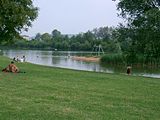
The Great Bathing Lake (2006)
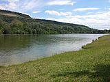
View over the large swimming lake (2016)


Architectural monuments
The Maria Hilf pilgrimage chapel, built in 1876, is located on the Volkenberg, which offers a view of the town and the Main Valley. The remains of the Falkenstein Castle are in the immediate vicinity.
Regular events
The summer night festival, the street wine festival and the mountain festival are organized annually by local associations.
From 1995 to 2005 the open-air play "Broken Swings" was performed on the Erlabrunn cultural stage, which dealt with the history of Falkenberg Castle and Ravensburg and the murder of Würzburg Bishop Konrad von Querfurt. The performance was resumed in 2009 on the occasion of the 800th anniversary of Erlabrunn.
Culinary specialties
The wineries operate " hedgerows ".
Economy and Infrastructure
traffic
The only connecting road to the village is the state road St 2300, which leads north to Zellingen and south to Margetshöchheim. As the through traffic became too narrow for through traffic, the Erlabrunn bypass was opened in 1987. The Erlabrunn barrage crosses the Main, although it is only open to pedestrians. Despite its location on the river, Erlabrunn does not have a special landing stage for ships. They only have the option of mooring at the quay wall south of the barrage, i.e. upstream. Erlabrunn also had a train station in the past, but due to its location on the opposite side of the Main and the associated distance to the town, it was hardly used and was therefore closed.
Economy including agriculture and forestry

In 2017 there were 58 jobs subject to social security contributions in the municipality. Of the resident population, 731 people were in an employment relationship subject to compulsory insurance. This means that the number of out-commuters was 673 more than that of in-commuters. 16 residents were unemployed. In 2016 there were 14 farms. These are exclusively wine and fruit growing businesses.
education
The day care center is operated by the St. Elisabethen-Verein eV. It has (as of 2018) 118 approved places and 92 children, 16 of them under three years of age.
The Erlabrunn primary school, which was built in 1958, has been a branch of the Margetshöchheim Association School since 1969, alongside the Leinachs and Zells primary schools. Since there is not enough space available, there is only a first class in Erlabrunn every other year. The first graders of the following year are taught from the first grade in Margetshöchheim. There are no secondary schools in Erlabrunn, there is a middle school in the neighboring municipality of Margetshöchheim, grammar schools, secondary schools as well as vocational schools and universities, especially in Würzburg.
The parish and community library is located on the ground floor of the school building. It is financed by the community, the parish and donations.
Web links
- Erlabrunn municipality
- Erlabrunn: Official statistics of the LfStat (PDF; 1.05 MB)
- Erlabrunn in the location database of the Bayerische Landesbibliothek Online . Bavarian State Library
Individual evidence
- ↑ "Data 2" sheet, Statistical Report A1200C 202041 Population of the municipalities, districts and administrative districts 1st quarter 2020 (population based on the 2011 census) ( help ).
- ↑ Municipal Council. Erlabrunn municipality, accessed on June 26, 2020 .
- ↑ a b Wolf-Armin von Reitzenstein : Lexicon of Franconian place names. Origin and meaning . Upper Franconia, Middle Franconia, Lower Franconia. CH Beck, Munich 2009, ISBN 978-3-406-59131-0 , p. 65 ( limited preview in Google Book search).
- ^ Karl Lott, Friedrich Petermann: Erlabrunn - way of life in harmony with nature. 1994, p. 6
- ↑ a b Description on the homepage of the SPD local association
- ↑ Information sheet of the Erlabrunn community from February 15, 2008, p. 17 f.
- ^ Karl Lott, Friedrich Petermann: Erlabrunn - way of life in harmony with nature. 1994, p. 9
- ↑ City council election 2020
- ↑ City council election 2020
- ↑ Mayoral election 2020
- ^ Entry on the Erlabrunn coat of arms in the database of the House of Bavarian History , accessed on September 8, 2017 .
- ↑ Info sheet of the Erlabrunn community, No. 9, from September 15, 2008
- ↑ quettehou.erlabrunn.free.fr ( Memento of July 28, 2007 in the Internet Archive )
- ^ Brokene-schwingen.de

Cities: Aub | Eibelstadt | Ochsenfurt | Röttingen
Markets: Bütthard | Eisenheim | Frickenhausen am Main | Gelchsheim | Gable City | Helmstadt | Höchberg | Neubrunn | Randersacker | Reichenberg | Remlingen | Rimpar | Sommerhausen | Winterhausen | Zell am Main
Municipalities: Altertheim | Bergtheim | Bieberehren | Eisingen | Erlabrunn | Estenfeld | Gaukönigshofen | Gerbrunn | Geroldshausen | Greußenheim | Güntersleben | Hausen near Würzburg | Hettstadt | Wooden churches | Kirchheim | Box | Small cattle field | Kürnach | Leinach | Margetshöchheim | Oberpleichfeld | Prosselsheim | Riedenheim | Rottendorf | Sonderhofen | Tauberrettersheim | Theilheim | Thüngersheim | Uettingen | Unterpleichfeld | Veitshoechheim | Waldbrunn | Waldbüttelbrunn
Unregulated areas: Gramschatzer Wald | Guttenberg Forest | Irtenberg Forest